Hurricane Michael


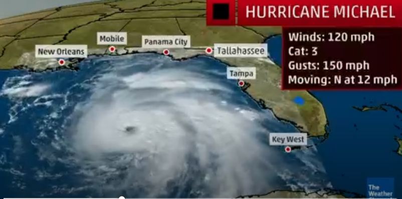
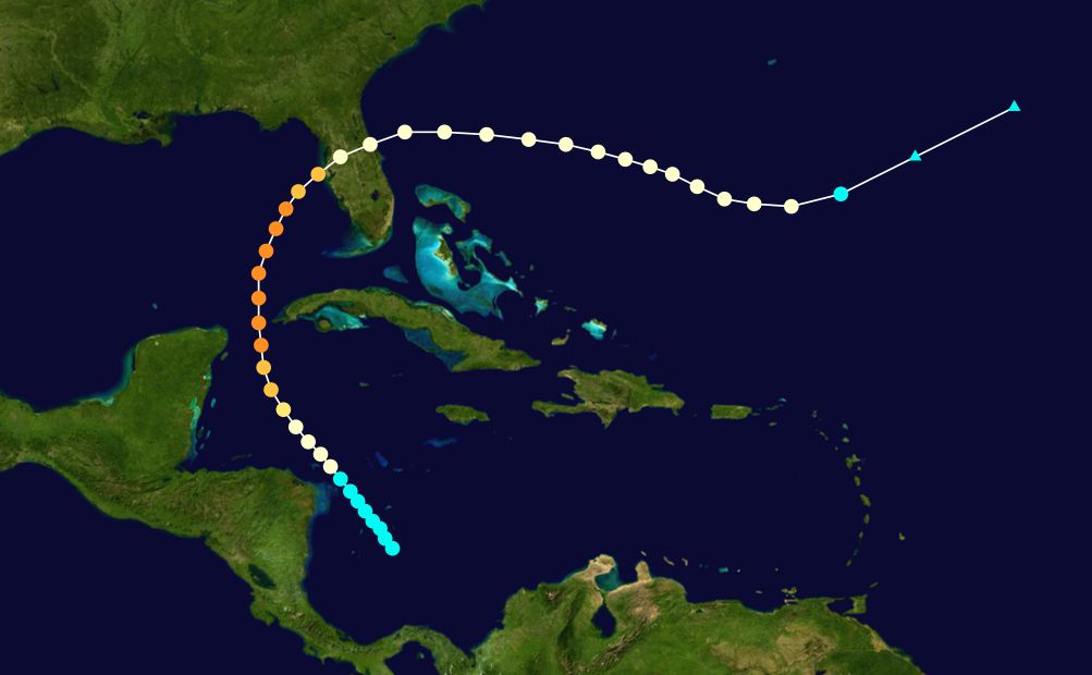
I want to thank everyone for sending in emails of concern with regard to Hurricane Michael. It is not likely to hit our area. However, the last bad hurricane to hit Tampa was in 1921 which was a Category 4 with 140 mph winds. It was an unusual storm like Michael which began in the Carribean during mid-October rather than in the Atlantic off the coast of Africa and normal. The storms that start in the Atlantic typically will not impact the West Coast. The storms that are most dangerous to this area are those that begin in the Carribean like Michael.

1921 TAMPA Category 4


The previous major hurricane was September 23–25, 1848 Category 4, which also formed in the Gulf of Mexico. There was also a lessor one in 1946 which was a Category 2, which also formed in the Gulf. The worst to hit the West Coast was Hurricane Charley in 2004 which hit as a Category 4. This one was an Atlantic storm which entered the Gulf and then turned right coming up the West Coast. The computer projections show a major one due in Tampa of a Category 4 to 5 probably in 2042-2043. That does not mean we will not see others of lesser intensity between 2018 and 2042/43.

Hurricane Michael Update: Current 85mph Rapid Intensification Predicted


As anticipate Hurricane Michael is showing signs of continued strength with each update. Current wind speed 85mph. Rapid intensification is predicted. Current forecast is for a Category 3 (115+ mph) storm at landfall.  If you are in the path you do not have much time to prepare. This storm is gaining forward speed as it strengthens.

[Hurricane Center] At 700 PM CDT (0000 UTC), the center of the eye of Hurricane Michael was located by a NOAA Hurricane Hunter aircraft near latitude 22.7 North, longitude 85.2 West. Michael is moving toward the north near 12 mph (19 km/h). A northward to north-northwestward motion at a slightly faster forward speed is expected through Tuesday night, followed by a northeastward motion on Wednesday and Thursday.

On the forecast track, the center of Michael will move over the southeastern Gulf of Mexico tonight, then move across the eastern Gulf of Mexico Tuesday and Tuesday night. The center of Michael is expected to move inland over the Florida Panhandle or Florida Big Bend area on Wednesday, and then move northeastward across the southeastern United States Wednesday night and Thursday.

Reports from the reconnaissance aircraft indicate that maximum sustained winds have increased to near 85 mph (140 km/h) with higher gusts. Steady to rapid strengthening is forecast during the next day or so, and Michael is forecast to become a major hurricane by Tuesday night. (read more)

For those in the cone of uncertainty, Florida Governor Rick Scott has provided an extensive update on state preparations – SEE HERE – More information is available on the Florida Emergency Website – SEE HERE.

Due to the speed of this storm, and the rapid intensification strength, all interests in the coastal area should immediate rush to completion their hurricane and storm preparation plans.  Tuesday is likely the only day to prepare your property and personal effects.  Do not delay.  Pay attention to the warnings and guidance of local officials.

If you live in an evacuation zone be prepared to respond as soon as instructed.  Take this storm seriously.  Slight variations in the storm’s path can create major changes within any impacted region.

Head’s Up – Tropical Storm Michael Forecast To Become Hurricane…


Coastal residents of Northern Florida (Panhandle), Alabama, Mississippi and Louisiana should keep an eye on tropical storm Michael.  The storm is anticipated to become a Hurricane in the northern Gulf of Mexico sometime late Tuesday/Wednesday.

At 100 PM CDT (1800 UTC), the center of Tropical Storm Michael was located near latitude 19.2 North, longitude 86.9 West. Michael is currently stationary but is expected to resume a slow northward motion later today. A northward motion with some increase in forward speed is expected over the next few days. On the forecast track, the center of Michael will move near the northeastern tip of the Yucatan Peninsula Monday morning, and then across the eastern Gulf of Mexico late Monday through Wednesday morning.

Maximum sustained winds are near 40 mph (65 km/h) with higher gusts. Strengthening is forecast during the next several days, and Michael could become a hurricane by Tuesday night or Wednesday. (More from hurricane center)

Katla Building to a Major Event?


They claim that all the world’s nations combined pumped nearly 38.2 billion tons of carbon dioxide into the air from the burning of fossil fuels such as coal and oil, according to new international calculations on global emissions published in the journal Nature Climate Change. That is 32 kilotons per day when one volcano Katla, which is a huge hidden volcano 650 feet beneath the ice cap in Iceland, is emitting 20 kilotons of C02 every day. There are only two volcanoes worldwide that are known to emit more CO2, and now scientists are concerned that Katla may be headed toward a major eruption. Obviously, the UN should be imposing a tax on Iceland for all this added Co2.

Katla has had about 20 eruptions in the last 1100 years. There were eruptions which have been documented in the years 920 and 1612, and from 1821 to 1823. These latter eruptions in the 19th century helped to cool the planet contributing to the mini ice age at that time. The last eruption that actually broke through the ice cap occurred in 1918. There have been subglacial flood events in 1955, 1999 and 2010-2011 that melted ice but it did not break the surface. These events do create flooding as the ice melts. Volcanic activity produced two eruptions in 2010 at Eyjafjallajokull, on March 20 and April 14. The second eruption created the giant ash cloud over Europe which diverted air traffic.

The 1918 ash plume was documented to have reached heights of 14 km. That event looked like a mushroom cloud from an atomic bomb. It is hard to draw a conclusive model since the majority of eruptions only melt ice beneath the surface. The best we can do with an approximation for the events that break through the surface puts it in 2020-2021 for the next ideal event. But the data series is not definitive on this event. It does appear that Katla has become active again since 2010 and is building to a climax. This could also be an event that contributes to global cooling as we saw during the 19th century