Hurricane Milton Departs Florida


Posted originally on the CTH on October 10, 2024 | Sundance

Hurricane Milton hit Siesta Key as a cat-3 storm with hurricane winds 35 miles from center, and Milton departs Florida near Cape Canaveral as a cat-1 storm with hurricane winds extending 35 miles from center.

Tampa Bay narrowly avoided a direct hit as Milton made landfall 70 miles south. Milton made landfall near Siesta Key, at 8:30 pm Wednesday as a Category 3 storm. At landfall, the storm was producing maximum sustained winds of 120 mph while moving toward the northeast at 15 mph.

As the sun rise Hurricane Milton leaves a wake of tremendous damage behind him across the entire state.   Assessments are now being made.

At 500 AM EDT (0900 UTC), the center of Hurricane Milton was located near latitude 28.5 North, longitude 80.5 West. Milton is moving toward the northeast near 18 mph (30 km/h) and this general motion is expected to continue today, followed by a turn toward the east tonight. On the forecast track, the center of Milton will move away from Florida and to the north of the Bahamas today.

Maximum sustained winds are near 85 mph (140 km/h) with higher gusts. Gradual weakening is expected, but Milton is forecast to become a powerful extratropical low tonight. Hurricane-force winds extend outward up to 35 miles (55 km) from the center and tropical-storm-force winds extend outward up to 205 miles (335 km). (more)

If you are in the area let us know how you are doing.

Tampa10 Livestream Below:

5pm Update – Hurricane Milton Nears Tampa Bay Area


Posted originally on the CTH on October 9, 2024 | Sundance

Hurricane Milton is traveling at a forward speed around 17 mph. With winds near 120 mph the eye of the storm is roughly 70 miles wide (35 miles from center). The storm is wavering in strength but should be anticipated to maintain this intensity as it makes landfall tonight.

The National Hurricane Center is forecasting just south of the Tampa Bay area as the most likely location for landfall. A few miles in any direction can make a big difference with this track. The greatest storm surge potential is south of the eyewall, extending well below the impact zone. Those who encounter the eye will likely be in strong hurricane force winds for 3 hours.

At 500 PM EDT (2100 UTC), the center of Hurricane Milton was located near latitude 26.9 North, longitude 83.4 West. Milton is moving toward the northeast near 17 mph (28 km/h), and this motion is expected to continue through tonight. A turn toward the east-northeast is expected on Thursday, followed by a turn toward the east on Friday.

On the forecast track, the center of Milton will make landfall near or just south of the Tampa Bay region this evening, move across the central part of the Florida peninsula overnight, and emerge off the east coast of Florida on Thursday.

Maximum sustained winds are near 120 mph (195 km/h) with higher gusts. Milton is a category 3 hurricane on the Saffir-Simpson Hurricane Wind Scale. Milton could still be a major hurricane when it reaches the coast of west-central Florida this evening, and it will remain a hurricane while it moves across central Florida through Thursday. Milton is forecast to weaken over the western Atlantic and become extratropical by Thursday night.

Hurricane-force winds extend outward up to 35 miles (55 km) from the center and tropical-storm-force winds extend outward up to 255 miles (405 km). A WeatherFlow site located in Egmont Channel (XEGM) recently reported a sustained wind speed of 51 mph (82 km/h) with a wind gust of 63 mph (102 km/h). A WeatherFlow site located on the Sunshine Skyway Fishing Pier (XSKY) recently reported a sustained wind speed of 47 mph (76 km/h) with a wind gust of 62 mph (100 km/h). The minimum central pressure based on Air Force Reserve Hurricane Hunter data is 948 mb (28.00 inches). (more)

While a strong wind threat exists for the Tampa Bay area, residents south of the impact zone should prepare for a long duration storm surge event.

Florida Governor Ron DeSantis Gives Update on Milton Preparation


Posted originally on the CTH on October 9, 2024 | Sundance 

Florida Governor Ron DeSantis gives an update on state preparations for Hurricane Milton.  There is a strong state emphasis on fuel supplies and alternatives from Port of Tampa to ensure fuel is available.  This is a very prudent approach.

Emergency debris cleanup operations were able to remove approximately 50% of all roadside debris from hurricane Helene.  To give you an idea of scale, during each hurricane landfall event the average of debris created equals 7 years of cumulative debris.  Meaning, each hurricane creates 7 years of debris in the impact zone.  Getting that moved out quickly is a monumental task.  FEMA reimburses the municipal region for the first 10 days debris removal post storm; this reimbursement window provides the county with motivation to get it done fast.

34 search and rescue teams from around the country have joined in staging areas alongside Florida groups.  There are expected to be 50,000 linemen in place for electrical grid restoration; this is the largest grid recovery mobilization in history.  500 state police from outside Florida have arrived to help in law enforcement post storm.  I am critical of DeSantis and his always political crew around him; however, when it comes to emergency leadership Governor Ron DeSantis does a great job. WATCH:

.

We will continue to monitor election events as well as national news events that are pertinent and continue posting articles.

I am also going to provide a link to livestreams below.  Clockwise from top left.  (1) Tampa Bay – rotating cam.  (2) Key West – the southernmost point closest to current storm. (3) Matlacha Bridge between Cape Coral and Pine Island. (4) Central Cape Coral amid one of the many canals.

Hurricane Milton, which was a Category 4 storm as of early Wednesday, is threatening the Tampa metro area — which has a population of more than 3.3 million people. Milton has the potential to be a direct hit and menacing the same stretch of coastline that was battered by Helene.  Milton is also threatening the same area that was hit hard by Hurricane Ian in 2022.

.

Final 12 Hours Hurricane Milton Prep – What You Can Still Do


Posted originally on the CTH on October 9, 2024 | Sundance 

By now I am assuming many people on the West and Southwest coast of Florida are either evacuated or staying put.  With approximately 12 hours before deteriorating conditions arrive, I have been asked for some last-minute advice.  [Full Prep Here]

Here’s the key part. Do not allow your mind to listen to the dark imaginings that create fear, stress and panic.  Stay busy, do stuff, you will find that taking an action-oriented approach will calm your mind.  Don’t just sit around and think about dark thoughts.

Yes, it is still possible to do some preparations – here is a quick recap of what you can look at in the final 12 hours of you are planning to hunker down.  Keep occupied.

♦ Change the voicemail message on your cell phone to let people know your plans. EXAMPLE:  “Hey, you’ve reached Sam, I’m ok and currently preparing for Hurricane Milton. Leave me a message and I’ll get back to you when possible.”  …..  After the storm, in an effort to reassure family, and in a method to preserve battery life on your phone, change the message again.  “Hey, you’ve reached Sam, I AM OKAY after the hurricane, and I am safe. If you leave a message, my reply may be delayed.”   This is one simple way to communicate to your friends and family, so they know you are okay.

Communication is important. Select a single point of contact for communication from you that all others can then contact for updates if needed. You can see the importance of this communication plan, from the recent results of the emergency in Western North Carolina. Tell your family who your primary contact person is, then tell that contact person your exact plans. That contact person then becomes the information hub for you that relays information to your family and friends.

♦ Clean up your documents. Organize your important papers, insurance forms, personal papers etc., and place them in ziploc bags, in a safe place. Some have suggested the dishwasher as a waterproof storage place.

♦ Secure your garage door. You can always tell those people who have been through direct hurricane impacts by how they parked their cars. I now include this information in all hurricane prep because it makes such a difference. If you lose your Florida garage door you will more than likely lose your roof. That’s just the reality of having a massive opening in your structure to 100 – 150 mph winds that could lift the trusses.

If you have two vehicles, put one vehicle inside the garage with the front bumper against the door to help stop the flex (do this carefully). Put the other vehicle outside blocking the garage door facing down the driveway or facing parallel to the garage. The goal is to use the aero dynamics of the car to push the wind away from the door and provide protection.

A cheap car cover can be used to protect the outside vehicle and/or use old blankets (cable ties, bungee cords) to stop the outside vehicle from getting sandblasted and destroyed. Place double folded corrugated cardboard in front of the radiator to protect it from storm debris.

You might still have time for this one.  If you live in a flood zone, or if you are concerned about storm surge, take your #1 car to the nearest airport or hotel with a parking garage and park in the upper levels. Take an cab/uber back home if you don’t have a friend or partner to help you. This way you know you will have one workable vehicle, just in case.

♦ Wash and sanitize the bathtub. Then fill the bathtub with water. AND/Or put three 30-gallon trash cans in the shower and fill them with water before the storm. This will give you 90 gallons of water for cooking and personal hygiene. You will also need water to manually flush your toilets. Bottled water is great for drinking, hydrating and toothbrushing, but you will need much more potable water if the municipal supply is compromised or broken. Use a bucket to flush your toilets with water from the tub, trash cans or pool.

♦ Bring in your patio furniture or throw it in the swimming pool. Put a heavy dose of chlorine in the pool now to compensate for the filter pump not working if the power goes out. Run the pump until the power goes out. Swimming pools can quickly turn into algae ponds following a hurricane.

♦ Remember, a standard 6,500-to-8,500-watt generator will run for approximately 8 hours on five gallons of gasoline.   If the power goes out, do not run it all the time.  Relax until it is safe to go outside and turn it on.  Turn it on, chill the fridge, make coffee, use the microwave or charge stuff, then turn it off.  Do this in 4-hour shifts and the fridge will be ok and your gasoline will last longer.  Gasoline is a scarce and rare commodity in the aftermath of a hurricane.  Gas stations don’t work without power.  Check the oil in the generator every few days.  Also, have a can of quick start or butane available in case the generator starts acting up.

♦ Do all of your laundry before the hurricane hits.  You will likely not have the ability again for a few weeks.  Your clothes washing machine is also a solid place to put ice where you don’t have to worry about melt.

♦ Cook meals in advance of the hurricane. Store in fridge so you can microwave for a meal.  Eating a constant diet of sandwiches gets old after the first week.  If you have a generator, you can use the microwave and coffee pot.

♦ Turn down the temp on your freezer now. Fill all empty space in your freezer or deep freeze with bottles of water. [You can also use some versions of Ziploc bags] Make sure you remove some water before positioning to allow room for ice expansion.  Use small bottles of water to fill small spaces. You can drink this water post storm but use it to fill space and help your freezer maintain temp during any power outage.

♦ You can also place a tall glass filled with water in the middle shelf of the Freezer. Let the water freeze. Before evacuating place a coin on top of the ice. If the coin is at the bottom of the glass when you return, throw out everything inside the fridge. That means the temp was compromised too long. Generally speaking, if you do not open the freezer door you have about 12 hrs safe food storage before you need to carefully evaluate.

♦ Check your radios and battery-operated devices to make sure they work.  Preset your broadcast channel to the one you feel most comfortable with.

It is very important to remain calm and stable.  This helps those around you as well as animals.  An approaching Hurricane is stressful, but it will be okay.  Do not allow your thoughts to turn toward fear and worry.  Instead, focus on proactive action that empowers you to prepare.

Say prayers for peace of mind and reassurance. You are NOT alone:

Heavenly Father, please grant me peace of mind and help calm my nerves. Our worldly worries are like a turbulent sea; and we need a very blessed balance that only You can provide.  We reach out to You for stability.

Dearest Lord, help me if I stumble and begin to worry. Give me the strength and clarity of mind to remain purposefully calm for my family. Keep my mind, spirit, words and deeds upon a clear path toward You. We trust Your Love God and know that You will provide calm amid this stress.

Just as Your sun rises each day against the darkest of nights; bring us clarity with Your light and grace.

In Your most merciful name, I pray.  ~ Amen.

Everything will be okay.

Hurricane Milton – All Preparations Along FL West Coast Should be Rushed to Completion


Posted originally on the CTH on October 9, 2024 | Sundance 

UPDATE:  My apologies for the prior update, too little sleep. Hurricane Milton 8:00am advisory. All interests in the Tampa area and South to Fort Myers/Naples should pay attention.

Today is the final day for any storm preparation. Conditions will deteriorate tonight as Milton approaches land. The exact location of impact is not yet defined. It looks like Sarasota Bradenton is in the bullseye. Information from the National Hurricane Center puts the predicted path at/near Tampa. Trust me, on this one a few miles will make all the difference.

At 800 AM EDT (1200 UTC), the eye of Hurricane Milton was located near latitude 25.0 North, longitude 84.8 West. Milton is moving toward the northeast near 16 mph (26 km/h). A northeastward motion is expected through tonight. A turn toward the east-northeast and east is expected on Thursday and Friday.

On the forecast track, the center of Milton will move across the eastern Gulf of Mexico today, make landfall along the west-central coast of Florida late tonight or early Thursday morning, and move off the east coast of Florida over the western Atlantic Ocean Thursday afternoon.

Maximum sustained winds are near 155 mph (250 km/h) with higher gusts. Milton is a category 4 hurricane on the Saffir-Simpson Hurricane Wind Scale. Milton is expected to remain an extremely dangerous major hurricane when it reaches the west-central coast of Florida tonight.

Hurricane-force winds extend outward up to 30 miles (45 km) from the center and tropical-storm-force winds extend outward up to 125 miles (205 km). The minimum central pressure based on NOAA and Air Force Reserve Hurricane Hunter data is 915 mb (27.02 inches). (more)

High tide in Tampa (Hillsborough) is at 6:11am tomorrow Thursday.  Unfortunately, a rising tide overnight can enhance the impact of storm surge. The total of the eyewall is currently 60 miles (30 miles from center). That’s an average buzzsaw in relative terms.  This one is slightly smaller than Ian (’22) in size and but moving faster 16mph. Keep praying for this one to get torn apart by windshear.

Evacuations and final preparations should be rushed to completion. Everyone must be in their hunker down location by evening. .

A forward speed of 16 mph will hopefully maintain so that Milton moves fast and does not have the additional opportunity to build energy from the Gulf of Mexico.  However, this is a very dangerous storm.

60-mile buzzsaw, 16 mph forward speed equals 4-hour duration for those with direct impact.  The storm surge (southern quadrant) will last approximately 2 additional hours to apex.

If you have ever heard the roof getting shredded (shingles ripping upward), you know the sound of bowling balls atop your house.  This is what should be expected for those who encounter the eyewall for any significant amount of time.

CTH will have more information as updates come available.  Coastal residents from Tampa south should have moved or are in the process of moving to areas without the worry of storm surge.

There is a lot of stress amid the population.  Remember to breathe, pray, calm yourself and think positively about events.  Focus on what you can do and stay calm amid crises.  It will be okay.

Keep praying for Milton to encounter significant upper-level winds from the North which can hamper its ability to strengthen.

Hurricane Milton – Florida Governor Ron DeSantis Press Conference


Posted originally on the CTH on October 8, 2024 | Sundance

Hurricane Milton’s unpredicted shift/wobble southward closer to Yucatan Peninsula now puts Milton on a more traditional East-NorthEast track as it heads toward the Southwest Florida Coast. [Latest NHC Update Here].

A large evacuation program is underway as people leave the west coastal Florida areas.  However, the exact path of Milton is still unknown. Florida Governor Ron DeSantis holds a press conference to discuss, among other things, the urgent distribution of fuel to assist in keeping fuel flowing to the gas stations on the evacuation routes.

Additionally, debris removal from the areas impacted by Hurricane Helene will continue through today on a 24 hour operation; which will continue until conditions deteriorate and it is no longer safe.  A massive assembly of state resources for search, rescue and recovery operations continue being staged.  Due to the needs in Eastern Tennessee and Western NC, an additional 36,000 linemen and power recovery operations are flowing toward Florida from far west.

.

As many of you are aware, my homebase is directly in the path.  I will provide updates as soon as possible and share plans for communication and ongoing CTH site operation (tonight).  We will pre-schedule the daily open threads so that discussion of all important topics can continue uninterrupted.

My message….  Despite the chaos around us in the deep south, for those outside the impact region, we need to keep pushing information for voter registrations (and ballot challenges) ahead of election deadlines and stay focused on the longer-term mission of MAGA 2024.  For those in the impact region – focus on your immediate needs, follow prior advice on planning and preparation, evacuate if needed.  Don’t forget to pause, breathe and PRAY. Love to all y’all. /SD

I am Evaculating


Posted originally on Oct 7, 2024 By Martin Armstrong 

Thank you for your support

Thank you for all the concern. The last one was not a direct hit—it was just tidal flooding—so I could sleep through the night, as did my dogs and even my neighbor. This one is a direct hit involving wind, rain, and tidal surge. I am evacuating for this one and moving inland. I am moving to a hotel. Hopefully, I will still have internet most of the time.

Florida Governor Ron DeSantis Gives Emergency Remarks Ahead of Hurricane Milton Arrival


Posted originally on the CTH October 7, 2024 | Sundance

lorida Governor Ron DeSantis just finished giving an update on preparations ahead of Hurricane Milton.  Replay Video Below.  There are multiple mandatory evacuations taking place along the western coast of Florida.

Milton came on the scene on Saturday as a tropical storm. Early Monday morning, Milton kicked off a rapid intensification starting as a Category 2 storm. By noon, the storm had strengthened to a large Category 5 hurricane, the National Hurricane Center said.  Florida state preparations are ongoing.

.

More info to follow later….

Hurricane Milton Update – Monday, Tuesday Preparation Window


Posted originally on the CTH October 7, 2024 | Sundance 

Hurricane Milton has intensified in the Eastern Gulf and is expected to gain strength over the next 24 hours.  On the positive side, most predictions have rapid deintensification in their models in the final 12 hours before landfall.  However, there are major variables still to be understood.

Overall, all interests on the west coast of Florida should use the next two days to complete preparation.  Today and tomorrow look like the best opportunity to secure property and prepare for a landfall event sometime late Wednesday/Thursday morning. The exact area of impact remains unknown.

(NHC) – […] An eastward to east-southeastward motion is forecast through tonight, followed by a turn toward the east and northeast on Tuesday and Wednesday. On the forecast track, Milton is forecast to move near or just north of the Yucatan Peninsula today and Tuesday, then cross the eastern Gulf of Mexico and approach the west coast of the Florida Peninsula by Wednesday.

Maximum sustained winds are now near 100 mph (155 km/h) with higher gusts. Milton is forecast to intensify rapidly and become a major hurricane later today. (read more)

Today is the day for all of us to prepare.

Due to this path, the area north of the impact eyewall will see winds offshore.  The area directly south of the impact eyewall will see winds directly onshore.   Preparations are always critical within the cone area; however, preparations for a west to east storm are even more critical.  A few miles and a little wobble can make all the difference in the storm surge.

For those in the cone of uncertainty, remember, planning and proactive measures taken now can significantly reduce stress in the days ahead. Plan when to make the best decision on any evacuation (if needed) consider Tuesday the decision timeframe. As a general rule: take cover from wind – but evacuate away from water.

The coastal area directly below Tampa/St Pete (Sarasota, Venice, Port Charlotte, Punta Gorda, Cape Coral, Matlacha, Pine Island, Bokeelia, Sanibel Island, Captiva Island, Fort Myers, Fort Myers Beach, Bonita Springs, Naples, Marco Island, and Ten-Thousand-Islands) should be on high alert and paying very close attention.

Again, the difference between Milton being above or below your location will make a lot of difference.

If Milton, traveling West to East, hits below you the hurricane force winds will initially be blowing offshore, pulling water out (tidal variables notwithstanding).  If Milton hits above you, the hurricane force winds will initially be blowing onshore, pushing water in.  When considering threat variables, the specifics of intensity and eyewall size will play a big role in determining impact scope, storm surge and subsequent damage.

It is very important to pay attention to your local officials and emergency management teams.  Each area is very different, and each community can feel a totally different impact depending on topographical, geographical and regional distinctions.  Listen to state officials, pay attention to the National Hurricane experts, but the best suggestion is to focus your attention on the advice of local EMS officials.

DAY TWO (Monday)
Get Storm Update
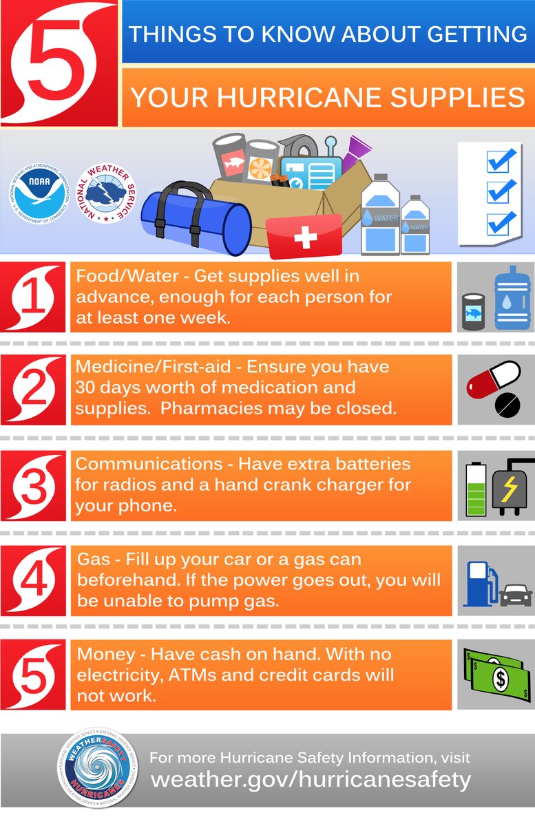
Assemble and Purchase Hurricane Supplies
Contact Insurance Company – Updates
Secure Important Papers.
Strengthen and Secure Your Home
Make Evacuation Decision for your Family.

DAY THREE (Tuesday)
Get Storm Update
Re-Evaluate your Supplies based on storm update
Finish last minute preparation
Assist Your Neighbors
If Needed – Evacuate Your Family

Communication is important. Update your contact list. Stay in touch with family and friends, let them know your plans. Select a single point of contact for communication from you that all others can then contact for updates if needed. Today/tomorrow are good days to organize your important papers, insurance forms, personal papers and place them in one ‘ready-to-go’ location.

You can see the importance of this communication plan, from the recent results of the emergency in Western North Carolina.  Tell your family who your primary contact person is, then tell that contact person what you EXACTLY plan to do.  That contact person then becomes the information hub for you that relays information to your family and friends.

Evaluate your personal hurricane and storm supplies; update and replace anything you might have used. Assess, modify and/or update any possible evacuation plans based on your location, and/or any changes to your family status.

Check your shutters and window coverings; test your generator; re-organize and familiarize yourself with all of your supplies and hardware. Check batteries in portable tools; locate tools you might need; walk your property to consider what you may need to do based on the storm’s path. All decisions are yours. You are in control.

Consider travel plans based on roads and traffic density. Being proactive now helps to keep any future stress level low. You are in control. If you have pets, additional plans may be needed.  Look over the National Hurricane Center resources for planning assistance. [SEE HERE]

You can always tell those people who have been through direct hurricane impacts by how they parked their cars.  I now include this information in all hurricane prep because it makes such a difference.  If you lose your Florida garage door you will more than likely lose your roof.  That’s just the reality of having a massive opening in your structure to 100 – 150 mph winds that will lift the trusses.

If you have two vehicles, put one vehicle inside the garage with the front bumper against the door to help stop the flex (do this carefully).  Put the other vehicle outside blocking the garage door facing down the driveway or facing parallel to the garage.  The goal is to use the aero dynamics of the car to push the wind away from the door and provide protection.

Purchase a cheap car cover to protect the outside vehicle and/or use old blankets (cable ties, bungee cords) to stop the outside vehicle from getting sandblasted and destroyed.  Place double folded corrugated cardboard in front of the radiator to protect it from storm debris.

Additionally, if you live in a flood zone, or if you are concerned about storm surge, the day before impact take your #1 car to the nearest airport or hotel with a parking garage and park in the upper levels.  Take an uber back home if you don’t have a friend or partner to help you.  This way you know you will have one workable vehicle, just in case.

♦ Another lesson from Ian, if you drive an electric vehicle and sustain saltwater intrusion (of any level) your car is not safe.  Saltwater makes the vehicle batteries extremely dangerous, and they could spark or catch fire.  Multiple homes survived Hurricane Ian only to have the electric car catch fire in the garage and burn the house to the ground.  Hurricane rain is wind-driven Gulf saltwater.  The fire department was begging people to put their EVs outside and not to plug them in.  Dozens of EVS also erupted in flames while driving down the streets after the storm.

♦ Hardening your home is a matter of careful thought and physical work.  However, every opening into your structure must be protected, leaving yourself with one small exit opportunity just in case. Hopefully you have a bolted door with no glass windows you can use as an emergency exit.  If not, select a small window and leave only enough room uncovered for you to get out in case of emergency or structural collapse.

Beyond the ordinary supplies like drinking water, batteries, flashlights, battery or hand-crank radio, generators, gasoline, etc.  Evaluate the scale of what you have against the likelihood of weeks without power or water.   A few pro tips below:

♦ Put three 30-gallon trash cans in the shower and fill them with water before the storm.  This will give you 90 gallons of water for cooking and personal hygiene.  You will also need water to manually flush your toilets.  Bottled water is great for drinking, hydrating and toothbrushing, but you will need much more potable water if the municipal supply is compromised or broken.

♦ A standard 6,500-to-8,500-watt generator will run for approximately 8 hours on five gallons of gasoline.   Do not run it all the time.  Turn it on, chill the fridge, make coffee, use the microwave or charge stuff, then turn it off.  Do this in 4-hour shifts and the fridge will be ok and your gasoline will last longer.  Gasoline is a scarce and rare commodity in the aftermath of a hurricane.  Gas stations don’t work without power.  Check the oil in the generator every few days.  Also, have a can of quick start or butane available in case the generator starts acting up.

♦ Extension cords.  If you are purchasing them buy at least one 100 to 150′ extension cord with a triple ponytail.  This way you can use one cord into a central location to charge up your electronic devices.  Establish a central recharging station for phones, pads, laptops, and rechargeable stuff.

♦ Purchase a box of “contractor garbage bags” and just keep them in the garage.  These are large, thick, industrial trash bags that fit 40-gallon drums. They can be used for trash, or even cut open for tarps in the aftermath of a storm.  These thick mil contractor bags have multiple uses following a hurricane.

♦ Do all of your laundry before the hurricane hits.  You will likely not have the ability again for a few weeks.

♦ Cook a week’s worth of meals in advance of the hurricane. Store in fridge so you can microwave for a meal.  Eating a constant diet of sandwiches gets old after the first week.  Dinty Moore canned beef stew and or Chef-boy-ardee raviolis can make a nice break…. anything, except another sandwich.

♦ Have bleach for use in disinfecting stuff before and after a hurricane.  Also have antibiotics and antiseptics for use.  Hygiene and not getting simple infections after a hurricane is critical and often forgotten.  Again, this is where the extra potable water becomes important.  Simple cuts and scrapes become big deals when clean potable water is not regularly available.  Keep your scrapes and abrasions clean and use antiseptic creams immediately.

♦ Do not forget sunscreen and treatments to relieve muscle aches and pains.  Hurricane recovery involves physical effort.  You will be sore and/or exposed to the elements.  Remember, it’s all about self-sufficiency because the normal services are not available.  A well-equipped first aid kit is a must have.

♦ Buy a small camping stove.  Nothing big or expensive, just something you can cook on outside in case of emergency.  It will be a luxury when you are 2+ weeks without power and all the stores and restaurants are closed for miles.

♦ Those small flashlights that you can strap around your head that take a few AAA batteries?  Yup, GOLD.  Those types of handsfree flashlights are lifesavers inside and outside when you need to see your way around.  Nighttime is especially dark without electricity in the entire town.  Doing stuff like filling a generator with gasoline in the middle of the night is much easier with one of those head strap flashlights.  Strongly advise getting a few, they’re inexpensive too.

♦ Cash.  You will need it.  Without power anything you may need to purchase will require cash, especially gasoline.  Additionally, anyone you hire to help or support your immediate efforts will need to be paid.  Cash is critical.  How much, depends on your individual situation, but your cash burn rate could go into the thousands in the first few days.  Also keep in mind, you may or may not be able to work and without internet access even getting funds into place could be challenging.

♦ Hardware. A box of self-tapping sheet metal screws (short and long) is important, along with a box or two of various wood screws or Tyvex screws.  A battery drill or screw gun is another necessity.  Check all of this stuff during hurricane prep.

What you do before the hurricane hits is going to determine where you are in the recovery phase.

Additionally, and this should be emphasized and discussed within your family, if you cannot be self-sufficient in the aftermath – for any reason, then you should evacuate.

Self-sufficiency in this context requires being able to cope for up to several weeks:

(1) potentially without power; (2) potentially without potable running water (3) potentially without internet service; (4) potentially without communication outside the region; and (5) with limited municipal and private sector assistance.

If you decide you cannot deal with these outcomes, you should evacuate.