President Trump Impromptu Presser From South Lawn – (Video and Transcript)…


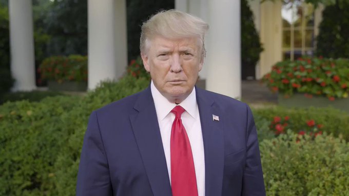
Chopper pressers are the best pressers.  As President Trump arrived back at the White House from Camp David, and just prior to a visit to FEMA Headquarters, he paused on the south lawn to answer media questions. [Video and Transcript Below]

.

[Transcript] THE PRESIDENT: Hello. First of all, I’d like to thank law enforcement yesterday, in Texas. They’ve been incredible. First responders, law enforcement, the police, the FBI, Governor Abbott — incredible, the job they did. It’s tragic, but they did an incredible job under the circumstances. It’s another very sick person.

So I just want to thank everybody involved. And always, you say: As bad as it was, it could have been worse. But it was certainly bad. Very, very sad situation.

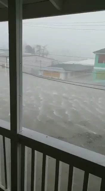
Also, I’d like to introduce Admiral Brown of the U.S. Coast Guard, a highly respected man. We spent two days at Camp David going over a lot of different things having to do with the hurricane. The Admiral has informed me through all of the different sources that he has — but you can pretty much get it on television, Admiral — this is now a Category 5. It seems to be one of the biggest hurricanes we’ve ever seen. And that’s a problem. That’s a problem.

So I think a lot of — we have a lot of great — we have a lot of great people working right now. We don’t know where it’s going to hit but we have an idea. Probably a little bit different than the original course. The original course was dead into Florida. Now it seems to be going up to toward South Carolina, toward North Carolina. Georgia is going to be hit. Alabama is going to get a piece of it, it looks like. But it can change its course again and it could go back more toward Florida.

So we’ll be knowing — we’ll be learning over the next probably, less than 24 hours. But it is a very, very powerful hurricane.

Q (Inaudible.)

THE PRESIDENT: Yeah, we’re looking at the same things. We’re in the process of dealing with Democrats, Republicans. They’ve been working very hard on it. They’re coming back very soon. And there’s a big package of things that’s going to be put before them by a lot of different people. We have a lot of groups working on it.

Q Mr. President, have you spoken to Senators Toomey, (inaudible), Wayne LaPierre (inaudible)?

THE PRESIDENT: Well, I’ve been speaking to them. I’ve been speaking to a lot of senators. We’ve been speaking to a lot of House members, a lot of Republicans, a lot of Democrats. And people want to do something. So we’re going to see.

This really hasn’t changed anything. We’re doing a package, and we’ll see what it all — how it comes about. It’s coming about right now. And a lot of people are talking about it. And that’s irrespective of what happened yesterday in Texas.

Q Mr. President, have you spoken to House Democrats about (inaudible)?

THE PRESIDENT: Well we’re looking at a lot of different things. We’re looking at a lot of different bills, ideas, concepts. It’s been going on for a long while. Background checks.

I will say that, for the most part, sadly, if you look at the last four or five — going back, even five or six or seven years, for the most part, as strong as you make your background checks, they would not have stopped any of it. So it’s a big problem. It’s a mental problem. It’s a big problem.

Q On China, sir, the new tariffs (inaudible) — have you spoken to President Xi?

THE PRESIDENT: So China is moving along. We’re doing very well. It was brought out very strongly today by a number of great economists that, because China has devalued their currency so much, that, in fact, they are actually paying for all of the tariffs. We have — in addition to that, as you know, they’re pouring money into their economy. So those two things, they are paying for their tariffs.

As you know, some new tariffs get on. We’re taking in tens of billions of dollars. We’re giving some of the money to the farmers. I’m making the farmers more than whole. The farmers are doing better than if China, frankly, were buying. I’m taking a piece of the massive amount of tariffs, and we’re giving them to the farmers who have been targeted unfairly by China.

We are talking to China. The meeting is still on, as you know, in September. That hasn’t changed. They haven’t changed and we haven’t. We’ll see what happens.

But we can’t allow China to rip us off anymore as a country. We can’t allow China to take $500 billion a year out of our country. We can’t do that.

Q Mr. President, do you have a message for Poland —

THE PRESIDENT: Yeah.

Q — on the 80th anniversary of the Second World War? What (inaudible)?

THE PRESIDENT: I do have a great message for Poland. And we have Mike Pence, our Vice President, is just about landing right now. And he is representing me. I look forward to being there soon.

But I just want to congratulate Poland. It’s a great country with great people. We also have many Polish people in our country; it could be 8 million. We love our Polish friends. And I will be there soon.

Q Mr. President, do you believe that Congress should (inaudible)? And why should Americans —

THE PRESIDENT: Say it. Say it. Speak up.

Q Mr. President, do you believe that Congress should (inaudible)? And why should Americans believe that now (inaudible)?

THE PRESIDENT: Well, I think Congress has got a lot of thinking to do, frankly, and they have a lot of — they’ve been doing a lot of work. I will tell you, on behalf of Republicans and Democrats, they’ve been doing a lot of work having to do with guns. And I think you’re going to see some interesting things coming along.

On the hurricane, Admiral, would you like to say something as to the size and scope of the hurricane?

ADMIRAL BROWN: Certainly, Mr. President. Thank you. This hurricane is very strong — Category 5 — which talks about the wind. It will also have substantial destructive, life-threatening storm surge, fresh-water rainfall in four states. Florida, Georgia, South Carolina and North Carolina can all expect to see tropical storm to hurricane-force impacts over the coming days. So the time for preparation is now.

THE PRESIDENT: And I’ll be going with the Admiral and many others over to FEMA in about an hour. And we’ll be having somewhat of a news conference over there where you won’t have the engines blaring. But we’ll have a news conference over at FEMA. So we’ll see you — most of you — there.

Okay? Thank you. Thank you very much.

END 11:21 A.M. EDT


President Trump Attends FEMA Briefing on Powerful Hurricane Dorian…

President Trump travels to FEMA Headquarters for a briefing on the current state of storm preparedness in advance of Hurricane Dorian having impact on the U.S. coastline.

.

WHITE HOUSE – President Donald J. Trump received a briefing today from senior members of his Administration and Governor Ron DeSantis of Florida, Governor Brian Kemp of Georgia, Governor Roy Cooper of North Carolina, and Governor Henry McMaster of South Carolina on the Federal and State efforts underway to prepare for and respond to Hurricane Dorian at the Federal Emergency Management Agency (FEMA).

The president began the briefing by offering his deepest sympathies for the tragic events in Odessa, Texas yesterday, praised first responders for their response, and reaffirmed his commitment to working with Congress to take decisive action to stop the scourge of mass attacks, and to reduce violent crime in all of its evil forms.

President Trump stressed to the Governors participating in the briefing that the Federal Government’s top priorities as Hurricane Dorian approaches the East Coast are providing life-saving and life-sustaining support to the State managed and locally executed efforts, and his Administration stands ready to assist in their readiness, response, and recovery operations.

President Trump asked everyone in Hurricane Dorian’s path to pay close attention to this dangerous and potentially life threatening storm, and heed all warnings and evacuation orders from State and local authorities to minimize any unnecessary risks for the public and our brave first responders. He stressed the most important task is the protection of innocent life, and expressed concern for the tens of thousands of Americans in the Bahamas.

Following the briefing President Trump toured the National Response Coordination Center and commended the efforts of Federal and state emergency managers, our brave military, and first responders for their actions before, during, and after the impact of Hurricane Dorian (LINK).

Catastrophic 185 MPH Hurricane Dorian Makes Landfall in Bahamas – East Florida Coast BE ALERT…..


Florida has suspended all roadway tolls as intensely powerful Hurricane Dorian continues a slow westward track over the Bahamas.  There is a great deal of uncertainty on the timing of any northward shift… Everyone on the east coast of Florida pay attention.

The eye-wall of category-five hurricane Dorian now carries 185 mph winds outward 45 miles from center.  This presents a 90-mile-wide buzzsaw of devastating impact.  It cannot be overstated how dangerous this storm has become.  Very few structures can withstand winds of that scale for any prolonged duration of time.  [Hurricane Center Update]

This is a ‘topography changing’ event.

At 200 PM EDT (1800 UTC), the extremely distinct eye of Hurricane Dorian was located near latitude 26.5 North, longitude 77.1 West. Dorian is moving toward the west near 7 mph (11 km/h). A slower westward motion should continue for the next day or two, followed by a gradual turn toward the northwest. On this track, the core of extremely dangerous Hurricane Dorian will continue to pound Great Abaco today and the move near or over Grand Bahama Island tonight and Monday. The hurricane should move closer to the Florida east coast late Monday through Tuesday night.

Maximum sustained winds are near 185 mph (295 km/h) with higher gusts. Dorian is a extremely dangerous category 5 hurricane on the Saffir-Simpson Hurricane Wind Scale. Some fluctuations in intensity are likely, and Dorian is expected to remain a catastrophic hurricane during the next few days.

Hurricane-force winds extend outward up to 45 miles (75 km) from the center and tropical-storm-force winds extend outward up to 140 miles (220 km).  (more)

For the east coast of Florida everything is contingent on a sharp turn north as predicted by the National Hurricane Center….  However, even a few miles further West can make a big difference.  Do not take the path of this storm lightly.

In the past 48 hours Dorian has only moved 0.3 degrees north in latitude.  It has been heading almost due West for the past two days.  The Bahamas are now experiencing one of the strongest hurricanes ever recorded; and unfortunately it is moving slowly.

If you are along the Florida east coast. Do not take chances. Listen to evacuation instructions from your local officials.

A Hurricane Watch is now in effect for: North of Deerfield Beach to the Volusia/Brevard County Line. All preparations should be rushed to completion.

Having personally been through four direct impact hurricanes from Andrew (’92) through Irma (’17).  Current hurricane Dorian is much more like Andrew (Homestead, FL), and it is simply too risky to stay.   If this storm doesn’t turn North as predicted it will mean significant problems.  The aftermath of life after a storm like this is very hard.

If you can leave the east coast it would be prudent to prepare NOW to do so.  As soon as any evacuation order is given, please leave.

Breaking911@Breaking911

Catastrophic damage reported at Abaco Islands in Bahamas

Embedded video

2,418 people are talking about this

11:00pm Hurricane Dorian – Powerful and Slow Westward Movement – Parts of East Florida Coastline Now Under TS Watch…


Hurricane Dorian now presents a 150mph wind force extending 30 miles from center.  That is a 60 mile-wide category-4 wind field.  A very powerful and dangerous storm. A rapid turn north is expected; the question is ‘when‘? A Tropical Storm Watch is now in effect for: Deerfield Beach to the Sebastian Inlet on Florida’s east coast.

In addition to Florida, residents in Georgia, South Carolina and North Carolina should be monitoring this storm closely.  Pay attention to local officials.

At 1100 PM EDT (0300 UTC), the center of Hurricane Dorian was located near latitude 26.3 North, longitude 75.1 West. Dorian is moving toward the west near 8 mph (13 km/h), and a slower westward motion should continue for the next day or two, followed by a gradual turn toward the northwest. On this track, the core of Dorian should be near or over portions of the northwestern Bahamas on Sunday, and move closer to the Florida east coast late Monday through Tuesday.

Data from NOAA and Air Force reconnaissance aircraft indicate that the maximum sustained winds remain near 150 mph (240 km/h) with higher gusts. Dorian is a category 4 hurricane on the Saffir-Simpson Hurricane Wind Scale. Some fluctuations in intensity are likely, but Dorian is expected to remain a powerful hurricane during the next few days.

Hurricane-force winds extend outward up to 30 miles (45 km) from the center and tropical-storm-force winds extend outward up to 105 miles (165 km). (read more)

We have a lot of Treepers in the path of this storm. If you need assistance, use the comments section of any Dorian Update thread to reach out, or use the email address in the upper right of the site.

Right now you are in control.  By now you should have a solid plan in place.  Work that plan, stay busy and don’t get caught up in the national hysteria.  Stay updated via your local news stations.

Reach out to your neighbors; touch-base and check to see if they are okay or need anything.  The community restoration begins before the storm arrives. Look out for each-other.  This is why preparation and communication is key.

Regarding any evacuation plan, please pay attention to your local officials who will be coordinating with state Dept. of Transportation.  As the path and impact zone of the storm becomes more predictable your local officials will alert to best route for evacuation.

For those in the cone of uncertainty; remember, planning and proactive measures taken now can significantly reduce stress in the days ahead.  Plan when to make the best decision on any evacuation (if needed).  As the storm has slowed consider Monday mid-day the latest decision time-frame. As a general rule: take shelter from wind – but evacuate away from water.

Communication is important.  Update your friends and family contact list. Stay in touch with family and friends, let them know your plans. Select a single point of contact for communication from you that all others can then contact for updates if needed.

Check your shutters and window coverings; test your generator; re-organize and familiarize yourself with all of your supplies and hardware. Check batteries in portable tools; locate tools you might need after the storm; walk your property to consider what you may need to do based on the storms path. All decisions are yours. You are in control.

Consider travel plans based on roads and traffic density. Being proactive now helps to keep any future stress level low. You are in control. If you have pets, additional plans may be needed.

Protect your family first, then help your friends and neighbors.

Above all else, stay calm.  Actively challenge yourself to stay calm regardless of the hysteria and/or alarm around you.  Stay calm and work your plan.

♦ Look over the National Hurricane Center resources for planning assistance.

♦ Also a great resource – CREATE A PLAN


Hurricane Dorian Intensifies – Category 4 Storm, 140mph Winds – Evacuations and Warnings Begin…


Re-Posted from The Conservative Tree house on  by 

As anticipated Hurricane Dorian has gained strength.  With winds of 140mph, Dorian is a dangerous category-4 storm. All interests in Florida are advised to pay close attention. Discussion follows update:

At 1100 PM EDT (0300 UTC), the center of Hurricane Dorian was located near latitude 25.5 North, longitude 71.4 West.  Dorian is moving toward the west-northwest near 10 mph (17 km/h).

A slower west-northwestward to westward motion should begin tonight and continue into early next week. On this track, the core of Dorian should move over the Atlantic well north of the southeastern and central Bahamas tonight and tomorrow, be near or over the northwestern Bahamas on Sunday, and be near the Florida east coast late Monday.

Data from a NOAA Hurricane Hunter aircraft indicate that the maximum sustained winds have increased to near 140 mph (220 km/h) with higher gusts. Dorian is a category 4 hurricane on the Saffir-Simpson Hurricane Wind Scale. Some additional strengthening is possible tonight and Saturday. Although fluctuations in intensity are possible early next week, Dorian is expected to remain a powerful hurricane during the next few days. (link)

The current forecast path has shifted slightly North and East.  If this general projection holds true through Saturday those below (south of) Lake Okeechobee may not be impacted by the most damaging part of the storm.  However, everyone needs to pay close attention to your local authorities and heed any evacuation advice.

A category four storm is very serious. Currently those winds extend outward 30 miles from the center; so the buzzsaw effect is approximately 60 miles wide.  Anyone inside the buzzsaw diameter will have damage of varying degrees depending on construction and variables therein.   Utility poles will snap, and trees will be uprooted.

We have a lot of Treepers in the path of this storm. If you need assistance, use the comments section of any Dorian Update thread to reach out, or use the email address in the upper right of the site.

Right now you are in control.  By now you should have a solid plan in place.  Work that plan, stay busy and don’t get caught up in the national hysteria.  Stay updated via your local news stations. Saturday looks like the key day impact zones will be identified.

Reach out to your neighbors; touch-base and check to see if they are okay or need anything.  The community restoration begins before the storm arrives. Look out for each-other.  This is why preparation and communication is key.

Regarding any evacuation plan, please pay attention to your local officials who will be coordinating with state Dept. of Transportation.  As the path and impact zone of the storm becomes more predictable your local officials will alert to best route for evacuation.

For those in the cone of uncertainty; remember, planning and proactive measures taken now can significantly reduce stress in the days ahead.  Plan when to make the best decision on any evacuation (if needed) consider Saturday mid-day the decision time-frame; Sunday morning at the latest. As a general rule: take shelter from wind – but evacuate away from water.

DAY ONE (Thursday/Friday)

  • Determine Your Risk
  • Make a Written Plan
  • Develop and Evacuation Plan
  • Inventory hurricane/storm supplies.
  • Withdraw cash based on plan/need.

DAY TWO (Saturday)

  • Get Storm Update
  • Assemble/Purchase Hurricane Supplies
  • Contact Insurance Company – Updates
  • Secure Important Papers.
  • Strengthen and Secure Your Home
  • Make Evacuation Decision for your Family.
  • Fill freezer with 3/4 full water jugs.

DAY THREE (Sunday)

  • Get Storm Update
  • Re-Evaluate your Supplies based on storm update
  • Finish last minute preparation
  • Plan for a minimum of THREE DAYS without power
  • Do all of your laundry.
  • Pack a suitcase as if traveling for 3 days, EVEN IF YOU DON’T leave.
  • ¹Sanitize tub and/or trash cans for water.
  • Assist Your Neighbors
  • If Needed – Evacuate Your Family

¹Tip: Place new trash bag in large trash can(s).  Place trash can in each bathtub or shower stall.   Unscrew shower head to quickly fill trash cans with water.  If you lose power you can use that water supply for general hygiene, and/or to flush toilets (via 1 gal bucket).

Save your bottled water for drinking and cooking.  Use lined trash cans of water for cleaning an hygiene purposes.  [If you have swimming pool, that’ll work too]

♦ Test everything.  Flashlights, radios, battery operated equipment etc.

♦ Charge everything.  Phones, computers and battery operated devices.

♦ Stage everything. Plan for worst. Select ‘safest room’, or largest closet, preferably without windows.  Place your critical items in this one stop location.

♦ Prepare food in advance.  In the final 24 hours, cook everything.  Cooked food lasts longer and is easy to reheat.  Make sandwiches etc.   Have high energy food readily available.

♦ Turn down your freezer, and/or lower fridge temp.  Fill all empty space in your freezer and fridge with bottled water (it will help hold temp down during power outage).

♦ Take a single cup full of water and place in freezer.  When frozen solid, place a coin or button on top of the frozen water.  If you evacuate, upon return if you lost power you will be able to tell from looking at the cup or glass.  If the coin or button is on the bottom of the glass/cup you know the freezer thawed at some point [throw out the food].  If the coin or button is still on the top of the ice, then everything in freezer should be safe.

♦ Place your important papers and extra money in your packed suitcase.  Make any emergency exit easier – think in advance.  Back your car into the garage, and after door closes carefully place your front bumper so it barely touches the door.  This will help reinforce.  Additionally, in absolute worst case scenario, you drive out through the door.

♦ Never run a generator in your house. EVER. Not even for a few minutes. Not even in the garage.  Just don’t do it. All generators must run outside. If you plan to use a generator, pre-position your extension cords prior to the storm and plan out their use.

♦ Have snacks and games pre-staged for kids in the “safe room”.   If you have pets, where will they be safe and secure?  If you use a large kennel for transport, set it up in advance or stage in your vehicle (likely an SUV) in advance.  Pets need food and water also.

♦ Prepare everything as a family.  Have the kids participate in all of the planning and staging, based on age and ability. Make it fun, and explain to them why you are doing things. Involve them in positive proactive activity; this will also help them stay calm.

Communication is important.  Update your friends and family contact list. Stay in touch with family and friends, let them know your plans. Select a single point of contact for communication from you that all others can then contact for updates if needed.

Check your shutters and window coverings; test your generator; re-organize and familiarize yourself with all of your supplies and hardware. Check batteries in portable tools; locate tools you might need after the storm; walk your property to consider what you may need to do based on the storms path. All decisions are yours. You are in control.

Consider travel plans based on roads and traffic density. Being proactive now helps to keep any future stress level low. You are in control. If you have pets, additional plans may be needed.

Protect your family first, then help your friends and neighbors.

Above all else, stay calm.  Actively challenge yourself to stay calm regardless of the hysteria and/or alarm around you.  Stay calm and work your plan.

♦ Look over the National Hurricane Center resources for planning assistance.

♦ Also a great resource – CREATE A PLAN

Hurricane Dorian Update 11:00pm – Storm Gains Strength, 105mph Winds – FL State of Emergency – Everything Mobilizing…


We have a lot of Treepers in the path of this storm.  If you need assistance, use the comments section of any Dorian Update thread to reach out, or use the email address in the upper right of the site.  [National Hurricane Center 11pm EST update]

Maximum sustained winds have increased to near 105 mph (165 km/h) with higher gusts. Dorian is expected to become a major hurricane on Friday and remain an extremely dangerous hurricane through the weekend. (more)

Right now you are in control.  Have a solid plan, work that plan – stay busy, and don’t get caught up in the hysteria.  Try to avoid national media hype. Stay updated via your local news stations. Saturday looks like the key day impact zones will be identified.  Reach out to your neighbors; touch-base and check to see if they are okay or need anything.  I always say the community restoration begins before the storm arrives. Look out for each-other.

Regarding any evacuation plan, please pay attention to your local officials who will be coordinating with state Dept. of Transportation.  As the path and impact zone of the storm becomes more predictable your local officials will alert to best route for evacuation.

For those in the cone of uncertainty; remember, planning and proactive measures taken now can significantly reduce stress in the days ahead.  Plan when to make the best decision on any evacuation (if needed) consider Saturday mid-day the decision time-frame. As a general rule: take cover from wind – but evacuate away from water.

DAY ONE (Thursday/Friday)

  • Determine Your Risk
  • Make a Written Plan
  • Develop and Evacuation Plan
  • Inventory hurricane/storm supplies.
  • Withdraw cash based on plan/need.

DAY TWO (Friday/Saturday)

  • Get Storm Update
  • Assemble and Purchase Hurricane Supplies
  • Contact Insurance Company – Updates
  • Secure Important Papers.
  • Strengthen and Secure Your Home
  • Make Evacuation Decision for your Family.
  • Fill freezer with 3/4 full water jugs.

DAY THREE (Saturday/Sunday)

  • Get Storm Update
  • Re-Evaluate your Supplies based on storm update
  • Finish last minute preparation
  • Plan for a minimum of THREE DAYS without power
  • Assist Your Neighbors
  • If Needed – Evacuate Your Family

Communication is important.  Update your friends and family contact list. Stay in touch with family and friends, let them know your plans. Select a single point of contact for communication from you that all others can then contact for updates if needed.

Today/tomorrow are good days to organize your important papers, insurance forms, personal papers and place them in one ‘ready-to-go’ location.

Evaluate your personal hurricane and storm supplies; update and replace anything you might have used. Assess, modify and/or update any possible evacuation plans based on your location, and/or any changes to your family status.  Fill car with gasoline. Review prescriptions, refill if needed.

Check your shutters and window coverings; test your generator; re-organize and familiarize yourself with all of your supplies and hardware. Check batteries in portable tools; locate tools you might need; walk your property to consider what you may need to do based on the storms path. All decisions are yours. You are in control.

Consider travel plans based on roads and traffic density. Being proactive now helps to keep any future stress level low. You are in control. If you have pets, additional plans may be needed.

One possible proactive measure is to make a list of hotels further inland that you would consider evacuating to.  Make that list today and follow updates of the storms’ progress; make reservations tomorrow if determined.

Depending on information tomorrow you might call in advance and make a reservation; you can always cancel if not needed.  It is better to have a secondary evacuation place established in advance.  Being proactive reduces stress.  Even if you wait until much later to cancel, it is better to pay a cancellation fee (usually one night charge) than to not have a plan on where to go.   Trust me, it’s worth it.  Protect your family. Make the booking decision in the next 24 hrs.

♦ Look over the National Hurricane Center resources for planning assistance.

♦ Also a great resource – CREATE A PLAN

Donald J. Trump

@realDonaldTrump

Embedded video

27K people are talking about this

11:00pm Hurricane Update – Dorian Gains Strength Entering Atlantic – Florida Declares Proactive State of Emergency…


Prep suggestions follow update. At 11:00pm EST (0300 UTC), the center of Hurricane Dorian was located near latitude 19.7 North, longitude 66.0 West. Dorian is moving toward the northwest near 13 mph (20 km/h), and this general motion is expected to continue through Friday. [National Hurricane Center]

On this track, Dorian should move over the Atlantic well east of the southeastern and central Bahamas on Thursday and Friday.  Maximum sustained winds have increased to near 85 mph (140 km/h) with higher gusts. Dorian is forecast to strengthen into a powerful hurricane during the next couple of days (more).

For those in the cone of uncertainty; remember, planning and proactive measures taken now can significantly reduce stress in the days ahead.  Plan when to make the best decision on any evacuation (if needed) consider Friday night the decision time-frame. As a general rule: take cover from wind – but evacuate away from water.

DAY ONE (Today, Thursday)

  • Determine Your Risk
  • Make a Written Plan
  • Develop and Evacuation Plan
  • Inventory hurricane/storm supplies.
  • Withdraw cash based on plan/need.

DAY TWO (Friday)

  • Get Storm Update
  • Assemble and Purchase Hurricane Supplies
  • Contact Insurance Company – Updates
  • Secure Important Papers.
  • Strengthen and Secure Your Home
  • Make Evacuation Decision for your Family.
  • Fill freezer with 3/4 full water jugs.

DAY THREE (Saturday)

  • Get Storm Update
  • Re-Evaluate your Supplies based on storm update
  • Finish last minute preparation
  • Plan for THREE DAYS without power
  • Assist Your Neighbors
  • If Needed – Evacuate Your Family

Communication is important.  Update your friends and family contact list. Stay in touch with family and friends, let them know your plans. Select a single point of contact for communication from you that all others can then contact for updates if needed.

Today/tomorrow are good days to organize your important papers, insurance forms, personal papers and place them in one ‘ready-to-go’ location.

Evaluate your personal hurricane and storm supplies; update and replace anything you might have used. Assess, modify and/or update any possible evacuation plans based on your location, and/or any changes to your family status.  Fill car with gasoline. Review prescriptions, refill if needed.

Check your shutters and window coverings; test your generator; re-organize and familiarize yourself with all of your supplies and hardware. Check batteries in portable tools; locate tools you might need; walk your property to consider what you may need to do based on the storms path. All decisions are yours. You are in control.

Consider travel plans based on roads and traffic density. Being proactive now helps to keep any future stress level low. You are in control. If you have pets, additional plans may be needed.

One possible proactive measure is to make a list of hotels further inland that you would consider evacuating to.  Make that list today and follow updates of the storms’ progress; make reservations tonight/tomorrow if determined.

Depending on information tomorrow you might call in advance and make a reservation; you can always cancel if not needed.  It is better to have a secondary evacuation place established in advance.  Being proactive reduces stress.  Even if you wait until much later to cancel, it is better to pay a cancellation fee (usually one night charge) than to not have a plan on where to go.   Trust me, it’s worth it.  Protect your family. Make the list of possibilities today, make the booking decision in the next 24 hrs.

♦ Look over the National Hurricane Center resources for planning assistance.

♦ Also a great resource – CREATE A PLAN

NBC News

@NBCNews

• Hurricane continues to move away from Puerto Rico and U.S. Virgin Islands, NHC says

• Maximum sustained winds are near 80mph; hurricane-force winds extend out to 15 miles.https://www.periscope.tv/w/1nAKEZmwaWgGL 

NBC News @NBCNews

LIVE: Latest Hurricane Dorian forecast and satellite images

pscp.tv

162 people are talking about this

Keep Eye on Dorian – Tropical Storm Advisory With Uncertain Forecast…


It’s that time of year when it is prudent to re-check your Hurricane plans and emergency supply kits.  Tropical Storm Dorian is approaching the western Caribbean heading toward Puerto Rico.  While the long-term forecast is unpredictable, it is worth taking this opportunity to re-evaluate your supplies, update if needed, and watch the forecast.

(National Hurricane Center) […] Dorian is moving toward the west-northwest near 13 mph (20 km/h), and this motion is expected to continue through tonight, followed by a turn toward the northwest on Wednesday. On the forecast track, the center of Dorian will move across the northeastern Caribbean Sea tonight, pass over or near western and central Puerto Rico on Wednesday, and move near or just east of eastern Hispaniola Wednesday night.

On Thursday night and Friday, the center of Dorian is forecast to move near or to the east of the Turks and Caicos and the southeastern Bahamas. Maximum sustained winds remain near 50 mph (85 km/h) with higher gusts. Slow strengthening is forecast during the next 24 hours, and Dorian is forecast to be near hurricane strength when it approaches Puerto Rico on Wednesday.

Some weakening is expected after Dorian moves across the higher terrain of Puerto Rico Wednesday night. Dorian is expected to gradually re-strengthen on Thursday and Friday while passing near or to the east of the Turks and Caicos and southeastern Bahamas. (link)

TS Barry – Possible Hurricane Barry – Louisiana and Mississippi Prepare for Extreme Flooding…


The latest storm advisory from the National Hurricane Center still shows Louisiana as the most likely impacted region of the northern gulf coast. Tropical Storm Barry will likely become Hurricane Barry shortly before landfall.  Severe flooding is the largest concern.

National Hurricane Center – At 4:00pm CDT (2100 UTC), the center of Tropical Storm Barry was located near latitude 27.8 North, longitude 89.3 West. Barry is moving toward the west near 5 mph (7 km/h) and this motion is expected to continue tonight. A turn toward the northwest is expected on Friday, followed by a turn toward the north on Saturday.

On the forecast track, the center of Barry will be near or over the central or southeastern coast of Louisiana Friday night or Saturday, and then move inland into the lower Mississippi Valley on Sunday.

Maximum sustained winds are near 40 mph (65 km/h) with higher gusts. Strengthening is expected during the next day or two, and Barry could become a hurricane late Friday or early Saturday when the center is near the Louisiana coast. Weakening is expected after Barry moves inland. (more)

.

Advertisements

Barry? Head’s Up Louisiana and Northern Gulf Region…


A storm is gaining strength in the northern Gulf of Mexico and the National Hurricane Center is now predicting organization to hurricane strength late Friday. If you live in a gulf coast community pay attention to storm updates.

At 1000 PM CDT (0300 UTC), the disturbance was centered near latitude 27.7 North, longitude 88.0 West. The system is moving toward the west-southwest near 9 mph (15 km/h). A motion toward the west is expected on Thursday, followed by a west-northwest motion on Friday and a northwestward motion by early Saturday. On the forecast track, the system is expected to approach the Louisiana coast this weekend.

Maximum sustained winds remain near 30 mph (45 km/h) with higher gusts. Strengthening is forecast during the next couple of days, and the disturbance is forecast to become a tropical depression early Thursday, a tropical storm by late Thursday, and a hurricane by late Friday. (LINK)

Ryan Kruger

@Ryan11Alive

We’re keeping an eye on the tropics on https://www.11alive.com/article/weather/hurricane/developing-tropical-system-forecast-to-make-landfall-this-weekend/85-8d061f04-d28f-4dc3-ba97-48ce54489137 

Developing tropical system forecast to make landfall this weekend

The National Hurricane Center forecasts this system to become a category one hurricane when it makes landfall in Texas or Louisiana

11alive.com

See Ryan Kruger’s other Tweets