Posted originally on the conservative tree house on September 28, 2022 | Sundance

As many long-time readers will know, we do have a little bit more than average experience dealing with the aftermath of hurricanes. I am not an expert in the before part; you need to heed the local, very local, professionals who will guide you through any preparation, and neighborhood specific guidelines, for your immediate area.
But when it comes to the ‘after part’, well, as a long-time CERT recovery member perhaps I can guide you through the expectation and you might find some value.
Consider this little word salad a buffet. If you are new to Florida hurricanes, absorb what might be of value pass over anything else.
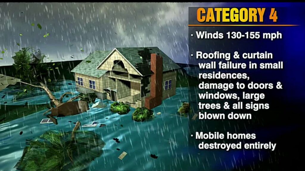
A category-4 storm can and will erase structures, buildings and landscape.
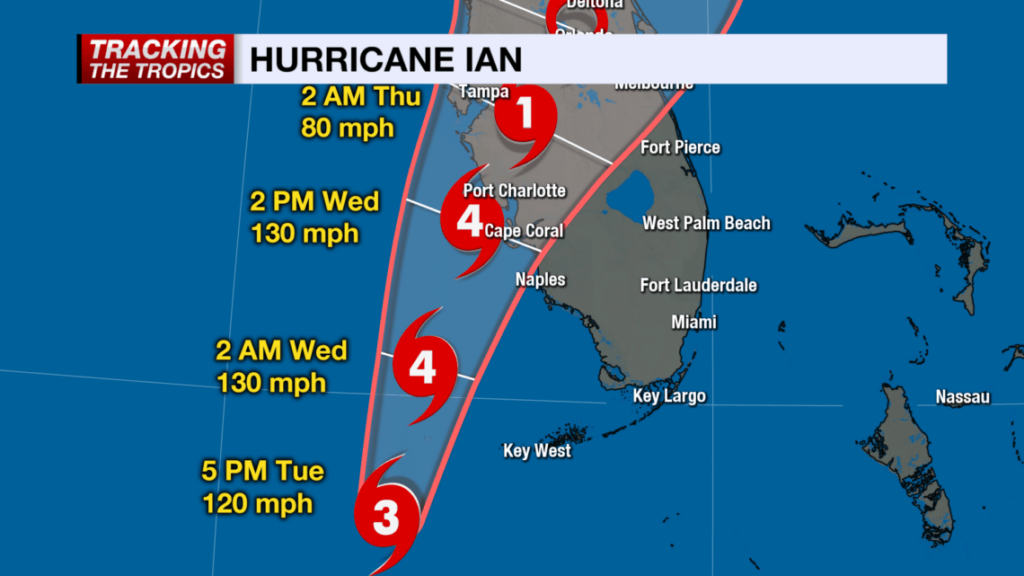
Hurricane Ian is similar to Hurricane Charley which impacted the SW coast of Florida in 2004, only a longer duration and therefore worse. The coastal topography and barrier islands will likely change in the 40-mile-wide area of immediate impact.
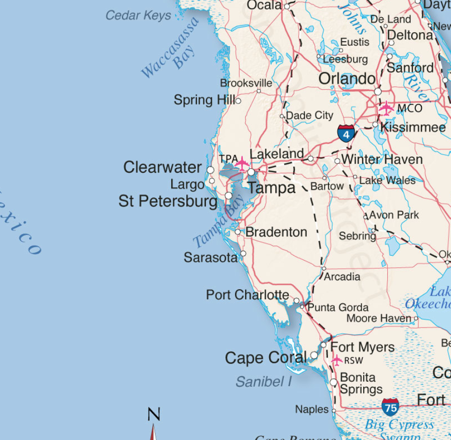
Sanibel Island, Bonita Beach, Fort Myers Beach, Captiva, Upper Captiva, Boca Grande, Pine Island, Cape Coral, Siesta Key, Longboat Key, Charlotte Harbor and Pine Island Sound could all be impacted.
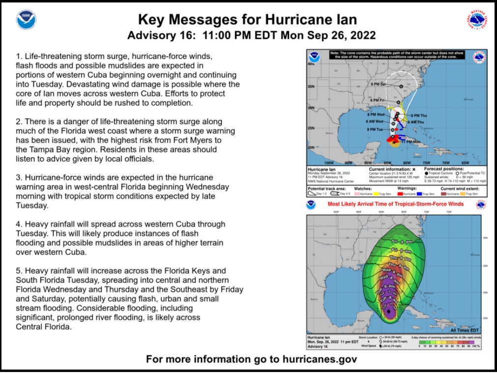
There is the potential for 18+ hours of hurricane force winds and two tides with storm surges. Total infrastructure failure should be anticipated, and it will take weeks for restoration. The coastal communities are the most vulnerable; however, the inland impact of the storm will continue unimpeded until the eyewall crosses onto land.
That means communities inland for roughly 50 miles could likely see consistent hurricane force winds for several hours. That scale of sustained wind energy will snap power poles and weaken reinforced concrete.
As the backside of the storm then reverses the energy direction, any already compromised structures will not withstand the additional pressure. In many cases the backside of the storm is worse than the front. If you are inland, you too should prepare yourself for long duration of extensive wind damage followed by an extended power outage.
For those who are in the path of the storm, there comes a time when all options are removed, and you enter the “Hunkering Down” phase. You’re there now.
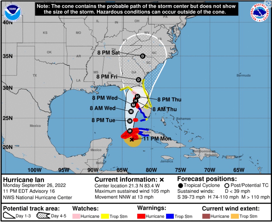
Ian is forecast to approach the west coast of Florida as an extremely dangerous major hurricane. Hurricane-force winds extend outward up to 40 miles (65 km) from the center and tropical-storm-force winds extend outward up to 140 miles (220 km). (link)

Unfortunately, unlike Charley, this particular hurricane Ian will stick around for more than the 2+ hours of the 2004 storm event. That brings a serious problem with coastal storm surge (two tidal cycles). In its totality from initial impact through recovery this is going to be a long-duration event.
When the sustained winds reach around 45mph only the more dire of emergencies get an immediate response. It is almost a guarantee that around the time emergency responders stop responding, too dangerous, you will lose power from the storm. Do not expect the power to be turned back on until it is safe, in this example recovery will be delayed by the slow forward progress of the storm.
Hurricanes can be frightening; downright scary. There’s nothing quite like going through a few to reset your outlook on just how Mother Nature can deliver a cleansing cycle to an entire geographic region. The sounds are scary. Try to stay calm despite the nervousness. Telephone and power poles, yes, even the concrete ones, can, and likely will, snap like toothpicks.
The ground in Southwest Florida is also completely saturated with heavy rains even before the storm began dumping water earlier on Monday. Trees that previously withstood Irma and even Charley, could likely bend, uproot and break; the sounds are dramatic.
There’s a specific sound when you are inside a hurricane that you can never forget. It isn’t a howl, it’s a roar. It is very unique sound in depth and weight. Yes, within a hurricane wind has weight. Stay clear of windows and doors, and within an interior room of the house or apartment if possible.
That scary roar will sound like it will never quit, especially for this specific slow-moving hurricane. It will stop, eventually; but at the time you are hunkering down, it doesn’t seem like it will ever end. This is the part that makes people say they will never go through that again. It is intensely unnerving. Imagine being impacted by a tornado for a full day.
A hurricane wind is a constant and pure rage of wind that doesn’t ebb and flow like normal wind and storms.
Hurricane wind is heavy, it starts, builds and stays, sometimes for hours. This one is forecast to be the longest in my memory. The wind is relentless, it just seems like it won’t let up. And then, depending on Ian’s irrelevant opinion toward your insignificant presence, it will stop.
Judging by the forward speed being stated by professionals at the National Hurricane Center, the hurricane force wind will likely last around 18 hours before it stops. Prepare your nerves as best you can for this.
Then silence. No birds. No frogs. No crickets. No sound.
Nature goes mute. It’s weird.
We have no idea how much ambient noise is around us, until it stops.

Due to the speed of this storm, there will be convoys coming to construct a pre-planned electricity grid recovery process around nightfall Thursday. Convoys from every city, town and state from the east-coast to the mid-west. A glorious melding of dirty fingernails all arriving for the meet-up. Depending on your proximity to the bigger picture objectives at hand, you will cherish their arrival.
But first, there will be an assessment. The convoys will stage at pre-determined locations using radios for communication. Most cell phone services will likely be knocked out. Recovery teams will begin a street-by-street review; everything needs to be evaluated prior to thinking about beginning to rebuild a grid. Your patience within this process is needed; heck, it isn’t like you’ve got a choice in the matter…. so just stay positive.
Meanwhile, you might walk outside and find yourself a stranger in your neighborhood.
It will all be cattywampus.
Trees gone, signs gone, crap everywhere, if you don’t need to travel, DON’T.
I mean CRAP e.v.e.r.y.w.h.e.r.e.
Stay away from powerlines.
Try to stay within your immediate neighborhood for the first 36-48 hours after the storm passes. Keep the roadways and main arteries clear for recovery workers, power companies and fuel trucks.
However, be entirely prepared to be lost in your own neighborhood and town for days, weeks, and even months. Unknown to you – your subconscious mind is like a human GPS mapping system. When that raging Ian takes away the subconscious landmarks I guarantee you – you are going to get lost, make wrong turns, miss the exit etc.
It’s kind of funny and weird at the same time.
Your brain is wired to turn left at the big oak next to the Church, and the road to your house is likely two streets past the 7-11 or Circle-k. You don’t even notice that’s how you travel around town; that’s just your brain working – it is what it is.

Well, now the big oak is gone; so too is the Circle-K and 7-11 signs. Like I said, everything is cattywampus. Your brain-memory will need to reboot and rewire. In the interim, you’re going to get lost… don’t get frustrated.
No street signs. Likely no stop signs. No traffic lights.
Remember, when it is safe to drive, every single intersection must be treated like a four-way stop…. and YOU ARE GOING TO HAVE TO PAY ATTENTION. Even the major intersections.
You’ll need to override your brain tendency to use memory in transit. You’ll need to pay close attention and watch for those who aren’t paying close attention.
Travel sparingly, it’s just safer.
Check on your-self first, then your neighbors. It doesn’t matter if you’ve never said a word to the guy in the blue house before. It ain’t normalville now.
Break out of your box and check on the blue house down the street too. In the aftermath, there’s no class structure. Without power, the big fancy house on the corner with a pool is just a bigger mess. Everyone is equally a mess.
The first responders in your neighborhood are YOU.
You, the wife, your family, Mrs. Wilson next door; Joe down the street; Bob’s twin boys and the gal with the red car are all in this together. If you don’t ordinarily cotton to toxic masculinity, you will worship its appearance in the aftermath of a hurricane. Git-r-done lives there.
Don’t stand around griping with a 40′ tree blocking the main road to your neighborhood. Figure out who’s got chainsaws, who knows how to correctly use them, and set about safely clearing the road. If every neighborhood starts clearing their own roadways, the recovery crews can then move in for the details.
Stage one focuses on major arteries… then secondary… then neighborhood etc. It’s a process.
Oh, and don’t get mad if your fancy mailbox is ploughed over by a focused front-end loader who is on a priority mission to clear a path. Just deal with it. Those same front-end loaders will also be removing feet of sand from coastal roads. Don’t go sightseeing… stay in your neighborhood.
For the first 36-48 hours, please try to stay close to home, in your neighborhood. Another reason to stay close to home is the sketchy people who can sometimes surface, looters etc. Staying close to home and having contact with your neighbors is just reasonable and safer.
Phase-1 recovery is necessarily, well, scruffy…. we’re just moving and managing the mess; not trying to clean it up yet. It’ll be ok. There are going to be roofing nails everywhere, and you will likely get multiple flat tires in the weeks after the hurricane.
After this storm half of the people living near Cape Coral, Punta Gorda and Port Charlotte are going to fit into two categories, two types of people: (1) those with a new roof; or (2) those with a blue roof (tarp).
Keep a joyous heart filled with thankfulness; and if you can’t muster it, then just pretend. Don’t be a jerk. You will be surrounded by jerks…. elevate yourself. If you need to do a few minutes of cussing, take a walk. Keep your wits about you and stay calm.
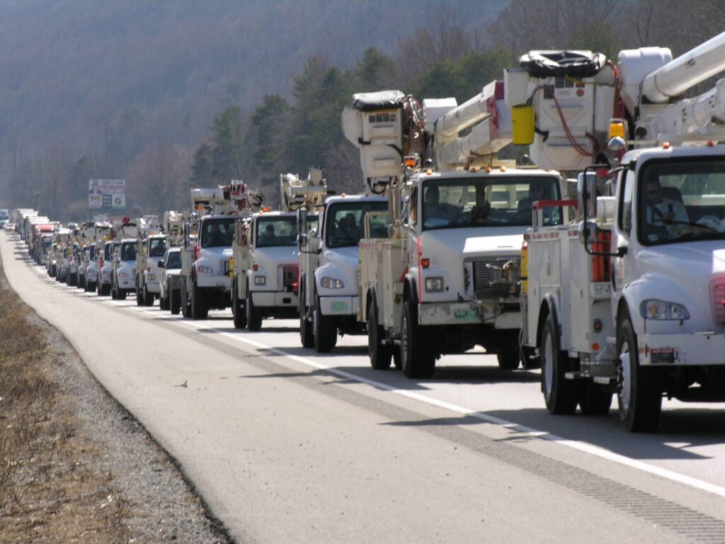
Now, when the recovery teams arrive…. If you are on the road and there’s a convoy of utility trucks on the road, pull over. Treat power trucks and tanker trucks like ambulances and emergency vehicles. Pull over, give them a clear road and let them pass.
When everyone gets to work, if you see a lineman, pole-digger or crew say thanks. Just simple “thanks”. Wave at them and give them a thumbs-up. No need to get unnecessarily familiar, a simple: “thank you for your help” will suffice. You know, ordinary people skills.
Many of these smaller crews will be sleeping in cots, or in their trucks while they are working never-ending shifts. Some will be staging at evacuation shelters, likely schools and such. The need to shelter people and recovery crews might also delay the re-opening of schools.
Once you eventually start getting power back, if you see a crew in a restaurant, same thing applies… “thanks guys”.
Same goes for the tanker truckers. The convenience stores with gas pumps are part of the priority network. Those will get power before other locales without power. Fuel outlets are a priority. Fuel is the lifeblood of recovery. Hospitals, first responders, emergency facilities, fuel outlets, then comes commercial and residential.
Remember, this is important – YOU are the first responder for your neighborhood. Don’t quit. Recovery is a process. Depending on the scale of the impact zone, the process can take days, weeks and even months.
Take care of your family first; then friends and neighborhood, and generally make a conscious decision to be a part of any needed solution.
Pray together and be strong together. Do not be bashful about being openly thankful in prayer.
It will be ok.
It might be a massive pain in the a**, but in the end, it’ll be ok.
√Andrew
√Jeanne
√Frances
√Ivan
√Charley
√Irma
√Michael
Ian
Keep a good thought. Who knows, we might even end up shaking hands.
It will be OK. Promise.