Hurricane Ian Update 11pm, West Coast Florida Residents Complete Preparation Tuesday Without Delay, Coastal Residents Pay Attention to Local Officials For Evacuation Orders


Posted originally on the conservative tree house on September 27, 2022 | sundance 

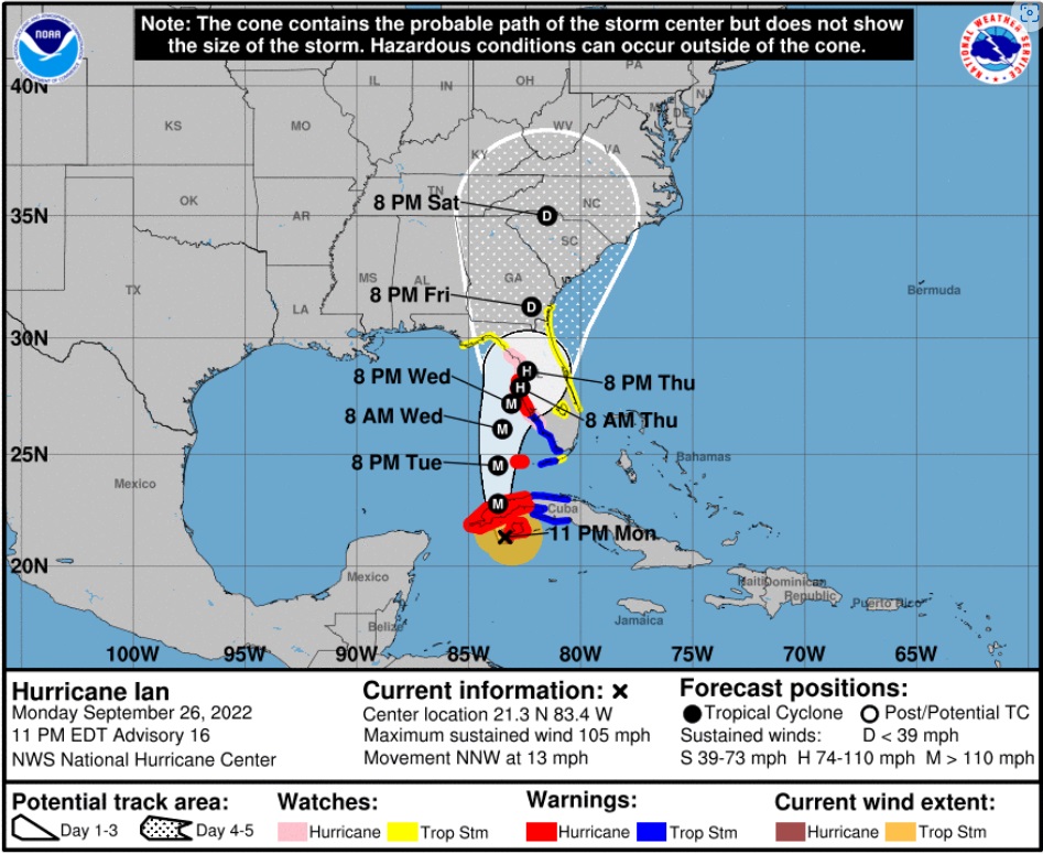
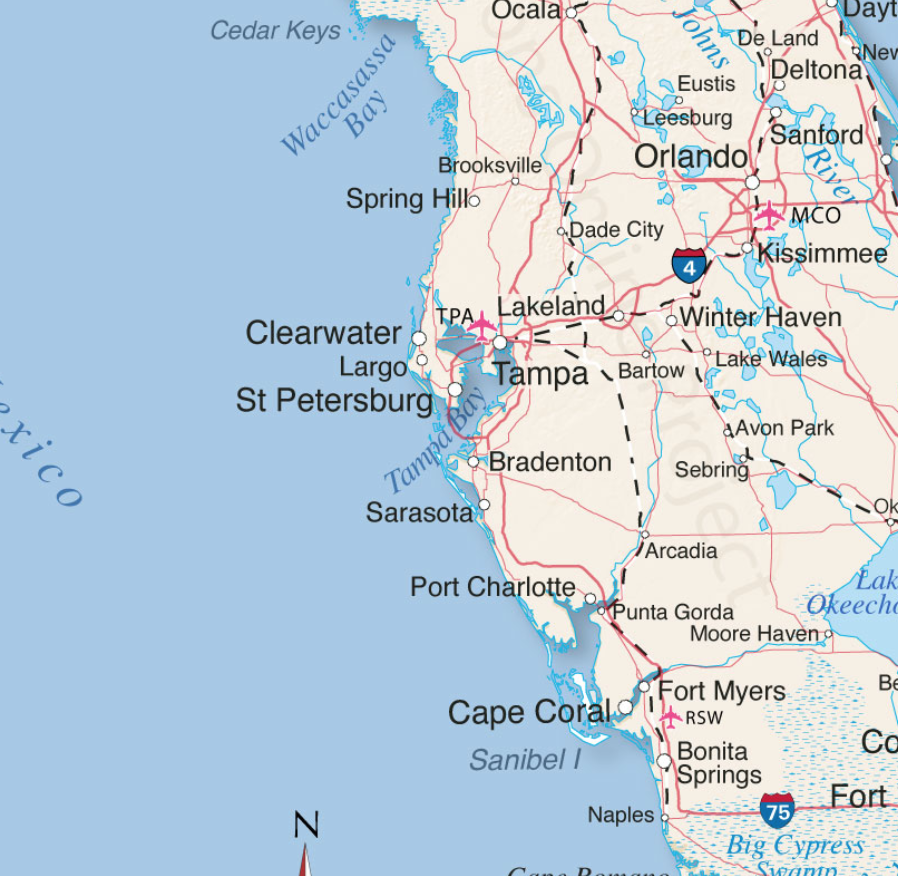
[National Hurricane Center Data]  As of 11:00pm ET Monday, Hurricane Ian has maximum sustained winds of 105 mph [Category 2].  Ian is anticipated to strengthen rapidly in the next 24 hours as it enters the Gulf of Mexico as a major hurricane [Cat 3+].  All west coast Florida residents from Bonita Springs to Tampa should use Tuesday to finalize their hurricane preparations.

Tuesday is the last good weather day to finish your preparations and secure your property.  Do not be alarmed but do take this hurricane seriously. This is not a ‘wait and see’ type storm.  All reasonable precautions should be completed today, and all coastal residents are urged to pay close attention to local officials for any evacuation orders.  Each locality is different, each coastal locality has a zone of potential flooding and storm surge.  As a general rule, hunker down from wind – but evacuate from water.

Official projections put the storm just off the Florida west coast on Wednesday night, with the potential for a 24-hour duration cycle. That is an alarming amount of time for a major hurricane to be centered near or on the coast.  That is a minimum of two tidal cycles, which will make a big difference from prior hurricanes in terms of flooding and the potential for a historic storm surge into inland waterways.

Hurricanes can be frightening; downright scary. There’s nothing quite like going through a few to reset your outlook on just how Mother Nature can deliver a cleansing cycle to an entire geographic region.  If this storm rests on/near the coast for the projected duration (24 hrs), things could be much more sketchy than other hurricanes.  This possibility is not something to dismiss.  No one in Florida has a reference.

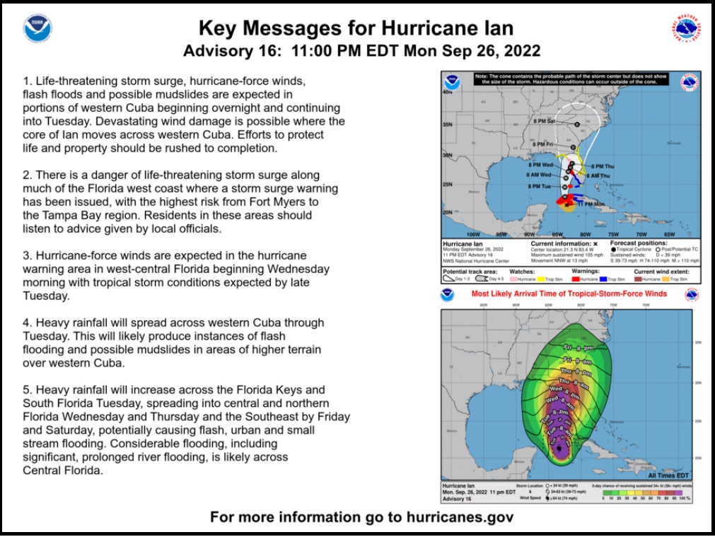
The geography on the south side of the storm faces the possibility of inbound wind and water for two tides, very uncommon.  Additionally, with outbound water limited by the pressure of inbound tides, the Peace River will flood, potentially at a historic level.  Let us hope the official forecasts are wrong, but we need to plan for this.  Projected rainfall is up to ten inches.

The deepest water will occur along the immediate coast near and to the right of the center, where the surge will be accompanied by large waves. Surge-related flooding depends on the relative timing of the surge and the tidal cycle, and can vary greatly over short distances. For information specific to your area, please see products issued by your local National Weather Service forecast office. [HERE’S LINK]  Pay attention to local officials.

Do not panic, but work your plan.

Dangerous coastal area storm surges are now predicted from Fort Myers north into Tampa Bay (south side of storm).  Please outline your communication plan with your family.  Select a specific person outside the area to be your immediate contact. That person then relays information to the rest of your family.  Please do this [Example Why].

Right now, you are in control.  Do not be alarmed – but take every preventative measure your individual situation needs.  Work your hurricane plan and stay focused on what you do control.  Work the plan, step by step and focus on what is in front of you.  Ignore the dark imaginings and turn off the national media.  Pay attention to your local officials and local media.

Finish your laundry. Sanitize and stage your water storage.  Inventory your supplies.  Organize your tools.  Fill your freezer with water jugs to take up room and freeze.  Test your generator. Stage your extension cords. Stage your battery powered devices. Test your weather radio. Take small steps to prepare.  Secure your home. You are in full control.  Today is the day to finish all preparation tasks.

The #1 priority is to keep calm. Keep stable.  If other people around you are panicked, do not let it impact your plan.  Stay focused. Stay organized. Stay in control.  I cannot emphasize enough how important it is for everyone around you and your family.  Everything is replaceable, except you and your family.  We have a lot of Treepers in the path of this storm. If you need assistance, use the comments section of any ‘Update thread’ to reach out, or use the email address in the upper right of the site.

DAY THREE (Tue/Wed)

  • Get Storm Update
  • Re-Evaluate your Supplies based on storm update
  • Finish last minute preparation
  • Plan for a minimum of THREE DAYS without power
  • Assist Your Neighbors
  • If Needed – Evacuate Your Family

.

Communication is important.  Update your friends and family contact list. Stay in touch with family and friends, let them know your plans. Select a single point of contact for communication from you that all others can then contact for updates if needed.

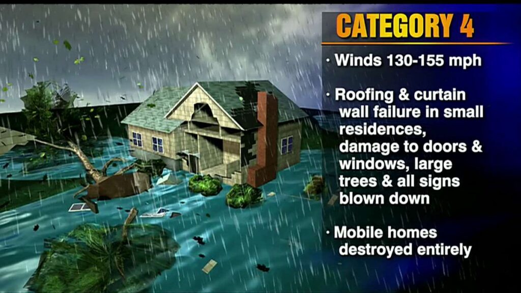
Telephone and power poles, yes, even the concrete ones, can, and likely will, snap like toothpicks. There’s a sound when you are inside a hurricane that you can never forget.

It ain’t a howling wind, it’s a roar. A damn scary raging roar that just won’t quit….

It will quit… eventually… but at the time you are hearing it, it doesn’t seem like it will ever end.

A constant and pure rage of scary wind that doesn’t ebb and flow like normal wind and storms… hurricane wind just starts and stays, sometimes for hours.

This type of wind is relentless and damn scary.  It takes you to that state where you begin to doubt things, it just won’t let up.

And then, depending on her irrelevant opinion toward your insignificant presence, she stops.

Then silence.

No birds. No frogs. No crickets. No sound.

Nature goes mute. It’s weird.

We have no idea how much ambient noise is around us, until it stops.

Oh, if she wants, she’ll keep dumping buckets on you as she wanders away. Buckets. Not pails, garbage can size buckets. After the scour, yup, nature too has a rinse cycle.

Prayers for all those in Ian’s path.

Pray together and be strong together.  It might sound goofy to some, but don’t be bashful about prayer – it works.

It will be ok.

Last point, housekeeping.  Most of the long-term Treepers know I will likely be unavailable as Civilian Emergency Response Teams (CERT) are activated.  The daily threads are auto scheduled to post, and the site admins will update on events if/when I am unavailable. My apologies to those who have written complaining that CTH is not providing the comprehensive coverage of political news.

Unfortunately, home base for all current research will consist of three duffel bags, a laptop, generator and a well-suited 4×4; loaded with power tools, emergency kits and assorted roughneck supplies. I will make every effort to return to political research and analysis – as soon as current logistics, community safety and overall concerns are abated. As part of FL CERT, we reposition outside of the storm surge area.  As a consequence, during the logistical move I will be out of the loop for most of the morning and early afternoon Tuesday.

To ensure continuance of communication, CTH has auto-scheduled posts set up throughout the week which will run automatically without any need for human data entry.  [ie. the website is secure and will function as normal – and site admins are disbursed throughout unaffected time zones] Other than my absence (hopefully sporadic), you should not see any disruption.

What can YOU DO?

Please pray for the people of Florida.  This is an extremely stressful time for many people, including a significant amount of elderly.  Unfortunately, due to modern disconnection a considerable number of people do not have frequent contact with family, COVID made this issue worse.

If you know people in Florida, please just reach out to them via social media, email, text, etc and let them know they are in your thoughts and prayers.  You don’t have to call them, you don’t need to look for a response, but a short note -just touching base- via social media (Facebook etc.), with kind words, can mean the world to people who might be feeling isolated.

Trust me, I’ve seen those faces all day.  It matters.

Florida Governor Ron DeSantis Gives Update on West Coast of Florida Evacuation Plans


Posted originally on the conservative tree house on September 26, 2022 | sundance 

With the forecasted path of Hurricane Ian anticipated to bring high water and winds to the west coast of Florida there is the potential for major storm surge in specific regions. Florida Governor Ron DeSantis held a press conference from Pinellas County to outline the latest information. WATCH: 

 ~ Florida Disaster Website as Outlined ~

TALLAHASSEE, Fla. — This morning, Governor Ron DeSantis issued updates on Hurricane Ian at the State Emergency Operations Center with Florida Division of Emergency Management Director Kevin Guthrie. Full remarks from this morning’s press conference are available here.

Hurricane Ian became a Category 1 hurricane this morning and is projected to continue strengthening into a major hurricane this week. Tropical-storm force winds may begin as soon as tonight in the Florida Keys and southern Florida. Regardless of Ian’s exact track and intensity, there is a significant risk of life-threatening storm surge, hurricane-force winds, and heavy rainfall along the west coast of Florida and the Florida Panhandle by the middle of this week.

Current Watches and Warnings in Effect:

  • Tropical Storm Warnings are in effect for the Lower Keys (from the 7 Mile Bridge southward to Key West, and the Dry Tortugas).
  • Tropical Storm Watches are in effect for portions of the Florida Gulf Coast stretching from Englewood to Chokoloskee (Charlotte, Collier, and Lee Counties).
  • A Hurricane Watch is in effect for Englewood to the Anclote River, including Tampa Bay.
  • Storm Surge Watches are in effect for the Florida Keys and mainland Monroe County, as well as far southern Miami-Dade, Collier, coastal Lee, the Tampa Bay area and coastal Charlotte counties.
  • Anclote River to Longboat Key including Tampa Bay… 5-10 ft
  • Longboat Key to Englewood… 5-8 ft.
  • Englewood to Bonita Beach, FL… 4-7 ft
  • Bonita Beach to East Cape Sable, FL… 3-5 ft
  • East Cape Sable to Card Sound Bridge, FL including Florida Bay…2-4 ft
  • Florida Keys including the Dry Tortugas… 2-4 ft

State preparation and response efforts include:

Florida Division of Emergency Management (FDEM)

  • FDEM is leading the State Emergency Response Team (SERT) for the Hurricane Ian response.
  • The Division has received 361 resource requests for Hurricane Ian, and has already fulfilled 293 of those requests. Additional requests are currently being processed and are either en route or being mobilized. This includes the coordination of resources such as: trucks of food and water, generators, and water pumps.
  • Five Urban Search and Rescue (USAR) Teams are activated, and will be prepared to deploy to impacted areas.
  • FDEM has begun setting up a Logistical Staging Areas in Polk County and is identifying potential additional staging areas and points of distribution to ensure food and water are readily available if counties request it.
  • FDEM has loaded 360 trailers with over 2 million meals and over one million gallons of water in preparation for distribution to impacted areas.
  • FDEM is in constant communication with all 67 county emergency management offices and state agencies to coordinate protective actions and needed resources ahead of potential storm impacts.
  • FDEM is coordinating with utilities to ensure crews are prepared to respond and restore power. Utility providers have more than 25,000 linemen staged and prepared for power restoration efforts.

Florida National Guard

  • Following Governor DeSantis’ authorization, a total of 5,000 Florida Guardsmen are being activated to State Active Duty and pre-positioned at armories across the state for Tropical Storm Ian response operations. Two thousand Guardsmen from Tennessee, Georgia and North Carolina are also being activated to assist.
  • The Florida National Guard is currently supporting missions including staffing and supporting the State Logistics Response Center (SLRC) in Orlando.
  • In addition, the Florida Guard has mobilized and is on standby with five Route Clearance Teams and Aviation assets.
  • The Florida National Guard is well-equipped, with assets including high-wheeled vehicles, helicopters, boats, generators and more.

Florida Department of Health (DOH)

  • DOH continues to coordinate across 67 county health departments on any necessary preparation resources, in coordination with county emergency managers.
  • The Department has coordinated with the Office of Insurance Regulation to distribute an alert regarding permitted early prescription refills during a State of Emergency. This alert was sent to health insurers, managed care organizations, health entities, and licensed health care providers. The alert can be found here.
  • The Department is supporting Special Needs Shelter operations in areas of anticipated landfall.
  • Nearly 300 ambulances, paratransit busses, and support vehicles are being deployed in areas of anticipated landfall.
  • The Department has coordinated with Federal partners to support the deployment of nearly 100 individuals through various health and medical teams. These teams stand ready in Orlando, Atlanta, and Warner Robbins Air Force Base in Georgia.

Agency for Health Care Administration (AHCA)

  • AHCA is requiring health providers to update the Health Facility Reporting System by 10 AM daily to ensure each facility is taking the appropriate precautions to ensure patient safety.
  • AHCA has completed 124 onsite visits in Nursing Homes and ALFs that were previously identified as out of compliance with generator requirements. As of today, 100% of operating long-term care facilities have a generator on-site. The Generator Status Map for long-term care facilities is available here.
  • AHCA has reminded all Medicaid Managed Care Plans of the requirement to allow 30-day emergency prescription refills of maintenance medication.

Agency for Persons with Disabilities (APD)

  • APD sent a statewide message to remind customers to register for the Special Needs Registry if needed.

Florida Department of Children and Families (DCF)

  • DCF submitted a request for a federal waiver to release SNAP benefits early in preparation for Hurricane Ian.
  • DCF has been working with contracted partners, including, Managing Entities, Community Based Care lead agencies, and child care providers to ensure Florida’s communities remain apprised of all storm updates and are making preparations for potential impacts.
  • DCF is also ensuring all Mental Health Treatment Facilities and methadone treatment programs are prepared for the storm.

Florida Department of Veterans Affairs (FDVA)

  • The Bay Pines VA Healthcare System will close the following locations for in person and procedure appointments:
  • C.W. Bill Young VA Medical Center: Monday, Sept. 26 through Thursday, Sept. 29. This closure extends to the Emergency Department.
  • North Pinellas and St. Petersburg VA Clinics: Wednesday, Sept. 28 and Thursday, Sept. 29.
  • Sarasota, Bradenton, and Port Charlotte VA Clinics: Wednesday, Sept. 28.

Florida Department of Transportation (FDOT)

  • To help Florida families safely and quickly evacuate in preparation of Hurricane Ian, tolls are now being suspended on many facilities in the projected areas of impact. Tolls will be suspended as of 12:00 PM today for the following:
  1. Polk Parkway in Polk County
  2. Suncoast Parkway in Pasco, Hernando, Hillsborough, and Citrus counties
  3. Veterans Expressway in Hillsborough County
  4. I-4 Connector in Hillsborough County
  5. Selmon Expressway in Hillsborough County
  6. Pinellas Bayway in Pinellas County
  7. Sunshine Skyway Bridge in Pinellas County
  8. Garcon Point Bridge in Santa Rosa County
  9. Spence Parkway in Okaloosa County
  10. Mid-Bay Bridge in Okaloosa County
  11. Alligator Alley in Collier and Broward Counties
  • FDOT contractors on all active construction projects are securing work sites, clearing traffic control devices that are not actively being used to direct traffic, and checking drainage systems.
  • Additional Road Rangers have been deployed to assist motorists along critical roadways.
  • The SunRail corridor is being secured to prepare for the storm. SunRail services will be discontinued effective Tuesday at 8:30am and will tentatively resume on Friday morning.
  • Florida’s 511 Traveler Information System is available for drivers to stay informed about roadway conditions during emergencies. The service includes traffic conditions, road and bridge closures, toll suspensions, and other specialized alerts. To use Florida’s 511, visit the website at FL511.com or download the app—on both Apple and Android devices.
  • On Saturday, September 24, FDOT waived standard weight restrictions for commercial vehicles transporting fuel, emergency equipment, services, supplies, and agriculture commodities and citrus. Commercial vehicles now will have an increased weight restriction to transport goods.
  • FDOT is monitoring traffic levels along critical corridors to ensure safe flow of traffic as the storm’s predicted path becomes clearer.
  • FDOT is staging resources to perform road and bridge inspections after the storm.
  • FDOT is procuring and staging resources to perform cut-and-toss operations to expedite roadway openings after the storm.
  • FDOT is activating district emergency and pre-event contracts for post-storm operations including debris removal, traffic signal and lighting repairs, and generators.
  • FDOT is coordinating with the Florida Highway Patrol, other law enforcement agencies, and Georgia DOT partners in support of potential evacuations, as well as with the Florida Department of Environmental Protection regarding debris management sites.
  • FDOT is working with utility providers to coordinate post-storm debris operations in support of electrical power restoration.
  • FDOT is coordinating with U.S. Coast Guard on movable bridge lockdowns.

Florida Department of Highway Safety

and Motor Vehicles (FLHSMV)

  • The Florida Highway Patrol is prepared to implement 12-hour Alpha, Bravo shifts in response to Hurricane Ian.
  • FLHSMV has issued Emergency Order 092422, which:
    • Waives specific requirements for commercial motor vehicles providing emergency relief; and
    • Waives the replacement fees for driver’s license and identification credentials, vehicle registrations and titles, vessel registrations and titles and temporary parking permits for impacted individuals.

Florida Wildlife Commission (FWC)

  • On September 23, at Governor DeSantis’ direction, the Florida Fish and Wildlife Conservation Commission (FWC) readied high-water vehicles and all other storm response resources so they may be rapidly deployed to assist Floridians in need in the event of any damage or flooding.
  • FWC officers in all 67 Florida counties have been placed on heightened alert status, in anticipation of heavy rains and flooding because of Hurricane Ian. High-water vehicles and shallow draft vessels in all Florida counties have been readied for immediate deployment to affected areas. Contingency plans based on forecasted landfall locations have been developed and are flexible based on the storm’s projected path.
  • Officers will respond with a variety of specialized equipment, including shallow draft boats, larger platform vessels, ATVs, airboats, and four-wheel drive vehicles. These assets do not include local FWC officers in potentially affected areas.
  • FWC Special Operations Group (SOG) teams will serve as reconnaissance units for the State EOC and report back on damage after the storm has made landfall.
  • FWC Aviation Section has been placed on standby and has readied all appropriate aircraft for potential deployment for EOC aerial assistance, reconnaissance, and post-storm damage assessments when needed.

Florida Department of Economic Opportunity (DEO)

  • DEO has activated the private sector hotline at 850-815-4925 from 8:00 a.m. to 6:00 p.m. Inquiries may also be emailed to ESF18@em.myflorida.com.
  • Partners including Walmart and Publix have indicated that they are constantly bringing additional supplies into the state to restock inventory.
  • DEO is updating www.FloridaDisaster.biz with real-time information for business owners to prepare their businesses, families, and employees for Hurricane Ian

Florida Department of Environmental Protection (DEP)

  • Following the issuance of the Governor’s Executive Order, DEP issued an Emergency Final Order waiving permitting requirements for the storage and processing of solid waste, including storm debris.
  • DEP has also issued an Emergency Final Order to expedite necessary repair, replacement and restoration of structures, equipment, surface water management systems, works and other systems damaged by the storm.
  • Inspectors completed pre-storm beach surveys in all shoreline counties.
  • Hazardous Area Response Teams (HARTs) are preparing for potential assessment and deployment to impacted areas.
  • All significant Hazardous Waste facilities within the affected counties have been contacted to ensure all pre-storm landfall preparations are being made.
  • Florida state park closures can be found at www.floridastateparks.org/StormUpdates.
  • Visitors with existing camping and cabin reservations at impacted parks will be notified of their reservation status.
  • WaterTracker is active, DEP’s online portal for wastewater and drinking water facilities to report their operational status.

Florida Department of Education (DOE)

The Florida Department of Education is consistently updating their website with county school closures, for a list visit fldoe.org/storminfo.

K12 School Closures

  • Hernando County Schools will be closed Tuesday, September 27 through Friday, September 30, 2022.
  • Hillsborough County Schools will be closed Monday, September 26 through Thursday, September 29, 2022.
  • Lake County Schools will have early dismissal on Tuesday, September 27 and will be closed Wednesday, September 28 and Thursday, September 29, 2022.
  • Pasco County Schools will be closed Tuesday, September 27 and Wednesday, September 28, 2022.
  • Pinellas County Schools will be closed Tuesday, September 27 and Wednesday, September 28, 2022.
  • Sarasota County Schools will be closed beginning Tuesday, September 27.

Florida College System Closures

  • Hillsborough Community College will be closed Tuesday, September 27 through Thursday, September 29, 2022.
  • St. Petersburg College will be closed Tuesday, September 27 and Wednesday, September 28, 2022.
  • State College of Florida will be closed Tuesday, September 27 through Friday, September 30, 2022.

State University Closures

  • New College of Florida classes will be canceled Monday, September 26 through Friday, September 30, 2022.
  • University of South Florida classes will be canceled Monday, September 26 through Thursday, September 29, 2022. Campuses will be closed starting Tuesday, September 27, 2022.

Florida Department of Management Services (DMS)

  • State buildings in Hillsborough County will be closed tomorrow, Tuesday, September 27, 2022. An updated list of state building closures is available here.
  • The Telecommunications Division is working with telecom partners to ensure that the state’s communications networks have redundancies and remain operations for first responders to respond to Floridians during the storm.

Posted in FEMAHurricane IanRon DeSantisUncategorized

The Rhine Drought


Armstrong Economics Blog/World Trade Re-Posted Aug 11, 2022 by Martin Armstrong

The drought across Europe has caused substantial problems. In Germany, the Rhine has all but evaporated. Freights have been forced to reduce their loads across the river, but some are foregoing the route altogether. German authorities have not closed the river but are permitting shippers to cross at their own risk — and it is a risk many are not willing to take. Shipping vessels have been sailing half to a quarter full, according to Reuters, adding to the supply chain bottleneck. Numerous companies are shifting to railway transportation but that will take time.

Around 80% of all goods transported to Germany via waterways come through the Rhine and this passageway is crucial for all of Europe. The last major drought occurred in 2018, prompting German authorities to close the passage for 132 days, which nearly triggered a financial crisis. The water was at a low of 27 cm in October 2018, and water levels are quickly rescinding.

Authorities will try to deter another shipping halt, but there won’t be much they can do if the water levels continue to drop. Some estimate that the Rhine will be closed to ships as soon as Friday. The implications will be far worse than in 2018, as there was not a global supply chain shortage exacerbating inflation.

The Heat Wave is Right on Target into Peak 2024


Armstrong Economics Blog/Climate Re-Posted Jun 17, 2022 by Martin Armstrong

COMMENT: Mr. Armstrong, your forecast for 2022 to be hot and dry has come true. It was 86 years from the Dust Bowl. Do you try to get those in government to listen? Obviously, all the dead cattle would have survived if people would just follow your model.

FD

ANSWER: I suppose I have given up in that regard. I think that is part of the crash and burn is necessary to change the thinking process. We are in the midst of climate change which has a natural cycle. The Dust Bowl was the same as we see today. There was extremely dry, hot weather that exacerbated farming and turned regions into scorching, dust wastelands. I remember in school they blamed the farmers saying they failed to rotate crops. But the record high summer temperatures in the Central U.S. during July 1936 had killed some 5,000 people in addition to livestock.

ABC News said that the temperature was forecast to reach 96 degrees in Minneapolis, which could see its longest June heat wave since 1949. The city has already had four days with temperatures in the 90s. Of course, everyone and their twice removed ex-spouse are blaming climate change. Why not? It’s just obvious. The actual record highs back then reached 112.5 degrees. Don’t worry, we still have time left for this to get even hotter.

If we are simply objectives, this is 86 years from 1936 when many called it a “living hell on Earth” during the Dust Bowl conditions. The National Oceanic and Atmospheric Administration recently announced that the 2021 meteorological summer (June-August) has matched 1936 as the hottest summer on record in the continental U.S. Over 18% of the Lower 48 states have experienced record warm average summer temperatures.

By 1937, they were talking about buying land that was no longer suitable for farming. All the hobos were former people who worked in agriculture and no longer had a job. These continuously rising temperatures are NOT human-caused climate change. People were dying from heart attacks during the 1936-1939 period.

The Dust Bowl began in 1935 and lasted for about 4.3 years into 1939. It has been our model which warned that post-2020 into 2024 would be a commodity boom and it would be based upon shortages. In addition to the stupidity of COVID, then the Ukraine War, add to that the climate, as we have one highly dangerous collision of cycles that were coming together beginning 2020.05.

Monkeypox – Old Virus, New Vaccine


Armstrong Economics Blog/Disease Re-Posted May 25, 2022 by Martin Armstrong

The US Biomedical Advanced Research and Development Authority (BARDA) is already developing a vaccine for monkeypox. Although the disease may seem novel, the first reported outbreak in monkeys occurred in 1958, and the first human infection was reported in the 1970s in the Democratic Republic of the Congo (DRC). According to the Centers for Diseases and Prevention (CDC), the virus is transmitted to humans through direct animal-to-human or human-to-human contact. Before they change the transmission guidelines, I will report what they stated on their website:

“Transmission of monkeypox virus occurs when a person comes into contact with the virus from an animal, human, or materials contaminated with the virus. The virus enters the body through broken skin (even if not visible), respiratory tract, or the mucous membranes (eyes, nose, or mouth). Animal-to-human transmission may occur by bite or scratch, bush meat preparation, direct contact with body fluids or lesion material, or indirect contact with lesion material, such as through contaminated bedding. Human-to-human transmission is thought to occur primarily through large respiratory droplets. Respiratory droplets generally cannot travel more than a few feet, so prolonged face-to-face contact is required. Other human-to-human methods of transmission include direct contact with body fluids or lesion material, and indirect contact with lesion material, such as through contaminated clothing or linens.”

The disease can reportedly occur through sexual encounters as well. This is NOT an airborne virus – masks and lockdowns would be useless. Cases of the virus are appearing throughout the world, but again, this virus was never limited to one continent. In 2003, 47 cases of monkeypox were reported in the US after pet prairie dogs became infected after being housed with small animals imported from Ghana.

BARDA plans to release JYNNEOS, a smallpox vaccine, to treat monkeypox cases by 2023. The company has already produced almost 13 million freeze-dried doses of the vaccine that are expected to be manufactured in 2024 and 2025.

President and CEO of Bavarian Nordic Paul Chaplin said, “We are pleased to announce the exercise of the first options under our contract with the US government to deliver a freeze-dried version of the smallpox vaccine with an improved shelf-life, which will be manufactured at our new fill and finish facility. This marks a significant milestone in our long-standing partnership with the US government to ensure availability of life-saving vaccines for the entire population.”

The European Medicines Agency approved the medication to treat monkeypox in 2013, and the FDA quietly approved its usage in 2019. Since this seems to be a rare illness, why are they planning to manufacture millions of doses to save “the entire population?” The media has only just begun reporting cases of the virus, and it would not be surprising if they pushed yet another unnecessary vaccine on the global population for profit and control.

Ok – Those who Voted for Biden & Want Global Cooling, Please Stay Out of Florida!


Armstrong Economics Blog/Climate Re-Posted Jan 26, 2022 by Martin Armstrong

The Tonga eruption & Volcanic Winter?


Armstrong Economics Blog/Agriculture Re-Posted Jan 26, 2022 by Martin Armstrong

The explosive eruption of the Hunga Tonga-Hunga Ha’apai volcano was massive. It would have covered much of California engulfing from San Francisco down to Los Angeles. They are still trying to figure out how big this event was yet it was certainly one of the largest to have taken place in modern times. The Volcanic Explosivity Index (VEI) is measured from 1 to 8. Pinatubo, which is considered similar to the Hunga Tonga-Hunga Haʻapai eruption, scored a 6 on the index. However, Pinatubo produced an eruption column of gas and ash that rose 40 km into the atmosphere, whereas this Tongan eruption was at least 20 km high.

Such events can cause what is known as a Volcanic Winter by the ash blocking the sun. That is what has taken place many times throughout recorded history. They called the year 1816 – the year without a summer. This  19th-century disaster, played out during 1816 when the weather in Europe and North America entered a volcanic winter with widespread crop failures resulting in famine followed by plague. The dust from the eruption of Mount Tambora, which had erupted in early April 1815, had shrouded the entire globe blocking the sunlight. This sent the world into darkness and 1816 did not have a normal summer. It even snowed in New York City during July.

The ash cloud of Tambora also affected the sky not just during the day but also caused the moon to be hazy and dark in appearance. In John Crome’s Moonrise on the Yare (c.1811–6) the moon is visible through the clouds just behind the buildings in the middle of the painting but barely. In the bottom left corner, we see a person working on a small boat in darkness.

It was about one year before the effects were actually felt. The weather in 1816 saw spring arrive as usual. Then as summer was to begin, cold temperatures returned. There were places where the sky appeared permanently dark and overcast. Crops failed due to the lack of sunlight and food shortages were reported in the United States, and throughout Europe. There was a feeling of doom that the world was coming to an end.

The Year Without a Summer also inspired Mary Shelley who was just 18 when she dreamed up her story of a “pale student of unhallowed arts” and the “hideous phantasm of a man” he created. She was a friend of the author Lord Byron who challenged her to write a ghost story. Her seminal classic of gothic horror, Frankenstein, was inspired during this period. Her first edition was one of 500 copies of this novel printed in 1818. Today, they are worth probably $1.5 million+.

It took more than a century before anyone really understood the reason for the Year without a Summer that it was a volcanic winter caused by the eruption of an enormous volcano on a remote island in the Indian Ocean. But what is significant here is that it took nearly one year for the ash to blank the globe. It was not instantaneous. Here, the blast was huge and it was visible from space. So we may not know about any possible Volcanic Winter for up to one year. When we look at our Food Index, note that the volatility began here in 2022 and will continue to rise into 2024. The mismanagement of Biden and this COVID agenda which has disrupted the supply chain combined with Bill Gates becoming now the largest farmland owner in the USA intent on disrupting the food supply further with his synthetic beef for climate change, throw in volcanic winter and the risk of war, and prices could rise further as supply shrinks.

We can see that Wheat jumped 350% during World War I from 1914 into 1919. Here we have the convergence of deliberate disruption of the food supply to further Gates’ vision of eliminating beef production, the advent of potential global war, and the serious risk of a Volcanic Winter especially if we get yet another massive eruption.

Volcanoes & The Risks Ahead


Armstrong Economics Blog/Nature Re-Posted Jan 15, 2022 by Martin Armstrong

Spread the lovemore

Hunga Tonga-Hunga Ha’apai volcano, which is a Submarine volcano, has erupted sending tsunamis off in every direction. The eruption has not yet been classified. However, it has been building since the March 16, 2009 (2009.205) eruption. There have been four eruptions since then and it does appear to be closer to a Pi cycle.

If we look at the volcanic activity in the entire region we can see this was then due to begin rising from 2019. There tends to be a general cyclical wave of 68 years looking at Tambora and Krakatoa which were 1815 and 1883. Kelud is one of the most active volcanoes in Indonesia that has major eruptions from time to time. The first explosion was around 1586. It had an eruption in 1951. The next target was 2019 marking the eruption of Tangkuban Perahu Volcano but a few months before Anak Krakatau became one of the most active volcanoes in Indonesia.

The key here appears to be that there are multiple eruptions of a lesser magnitude in 1815 and 1883 so they were not eruptions that were by themselves. The risk from volcanoes of a volcanic winter ahead would emerge when we see more coordinated eruptions that could lead to one major eruption that blocks the sun.

Sunday Talks, Kentucky Governor Andy Beshear Gives Horrific Update to Tornado Devastation, Entire Towns Gone, Death Toll Will Climb


Posted originally on the conservative tree house on December 12, 2021 | Sundance | 102 Comments

Kentucky Governor Andy Beshear gave a terrible update about the devastation in the aftermath of the horrific tornadoes that hit overnight Friday into Saturday morning.  According to the Governor, more than 70 are dead in a candle factory alone in Mayfield, and the death toll is expected to continue climbing as the list of missing people throughout the state is too long to fathom.

An official death count has not been released, but Beshear, appearing on CNN’s State of the Union, said at least 80 Kentuckians were feared dead with that number expected to rise. “I know we’ve lost more than 80 Kentuckians. That number is going to exceed more than 100,” he said. “This is the deadliest tornado event we’ve ever had.” WATCH:

Additional deaths have been reported outside of Kentucky including six at an Amazon warehouse in Illinois, four in Tennessee, two in Arkansas and two in Missouri.  More drone footage of the devastation was released earlier today. [See Below]

Raw Video Shows Horrific Tornado Devastation in Kentucky, At Least 70 Killed, Six States Impacted, National Guard Rescue Operations Continue


Posted originally on the conservative tree house on December 11, 2021 | Sundance | 271 Comments

The town of Mayfield, Kentucky has been absolutely devastated by at least one of several tornadoes that tore through six states overnight.  The video footage of the area shows widespread devastation, and the Kentucky governor is now reporting at least 70 people have been killed.

All Treepers in the region please check in and let us know how y’all are doing.  Our prayers are with everyone who was in the path of this massive storm system.  There are resources coming from all over the Southeast and Midwest into the region.  The images are jaw-dropping.

(Reuters) – A devastating swarm of tornadoes ripped through six U.S. states, killing more than 70 people in Kentucky and leaving a trail of destroyed homes and businesses along a path that stretched more than 200 miles, officials said on Saturday.

Dozens were feared dead at a candle factory in western Kentucky where about 110 people were working when a powerful tornado ripped through the facility late on Friday, causing the roof to cave in.  VIDEO:

Kentucky Governor Andy Beshear said 40 of the 110 workers had been rescued from the factory so far. “The level of devastation is unlike anything that I have ever seen,” Beshear said of the damage caused by the collection of twisters, with the primary tornado traveling more than 227 miles (365 km) across his state.

[…] The genesis of the tornado outbreak was a series of overnight thunderstorms, including a super cell storm that formed in northeast Arkansas. That storm moved from Arkansas and Missouri and into Tennessee and Kentucky.

“Unfortunately it produced a couple of deadly tornadoes along the way. One of them may have been a long-track tornado,” Storm Prediction Center meteorologist Roger Edward said. “The killer tornado was part of that.” (read more)

Almighty God, You are our healer. Our trust is in Your grace and power. We are blessed in Your name.

With You all rescue, recovery and healing are possible. We ask Your comfort upon those who have suffered such great tragedy.

We pray for Your comfort to relieve the anxiety of all who have been impacted. Let Your strength keep all the rescue workers going and find any who are lost.

Provide Your Holy Spirit to restore those who have suffered so much. Amen.