Global Temperatures Changes, Man Made or Not?


August, 2018 Report

We have been schooled over the past 40 years that Carbon Dioxide (CO2) is rising to levels never seen before on this planet and as a result the world’s average temperature is rising to levels that will, if nothing else, destroy large areas of the planet. The latest UN predictions indicate a major Catastrophe will happen by 2040 unless we do something drastic right now. This destruction will be from two factors; one, ocean levels raising and flooding all worlds coastal areas forcing the world population to higher ground; and two, even if those moves are accomplished the increased temperatures will bring massive storms that will ravage the areas not flooded. The only solution to prevent this from happening is, stop using carbon based fuels; petroleum, natural gas, and coal which, all, generate large amount of water and carbon dioxide and replacing them with wind or solar energy.

These dire projections are based on the belief that CO2 is the “primary” driver of global temperature changes; i.e. more CO2 in the atmosphere is very bad. This view is severally distorted and more likely entirely false.  One can argue the reasons for these lies but it really doesn’t matter whether they are innocent or malicious in their construct; either way promoting something that is tearing up the worlds civilizations by misallocation of resources is very misguided.

Basic facts:

  • The planets global temperature is directly related to the energy arriving here from our sun
  • That energy manifests itself in a form which we call temperature
  • Temperature is a measure of the amount of heat (energy) that an object holds
  • The planets temperature is directly related to the amount of water in the atmosphere
  • Without water in the atmosphere the earth would be 330 Celsius colder and frozen solid
  • Carbon Dioxide (CO2) is a requirement for life to exist on this planet
  • More Carbon Dioxide (CO2) is better as planets grow faster, less Carbon Dioxide (CO2) is bad
  • Carbon Dioxide (CO2) only indirectly affects temperature probably less than 5% that of water
  • Climate is a measure of the average of all the factors that produce a stable environment
  • Weather is a measure of local factors that may make large changes in daily or seasonal conditions
  • The planets temperature in geological times ranged from170 Celsius +/- 60 Celsius
  • 12,000 or so years ago the last ice age ended for no reason we can determine

The first thing that needs to be done when developing a theory is to identify and define the issue or problem. The issue was that after WW II there was a large buildup of industry required to rebuild the devastated planet and that rapid uncontrolled growth created real environmental problems. Much good resulted from the original environmental emphasis such as the creation of the Environmental Protection Agency, EPA, however, others in the 90’s saw a way to gain power and wealth by exaggerating aspects of the movement. During the 80’s and the 90’s global temperatures were going up so these people saw a way to increase the size and scope of government to their advantage with a carbon tax.  They picked increased levels of CO2 in the atmosphere as the strawman argument and funneled large amounts of research money into universities to study how bad the increases were.

Unfortunately, federal grant money is “directed” money so it was given to find out how bad the issue was, not to find out if it was even bad or even real. Therein was the problem as this is a very complex math and physics study in a subject that had not been previously studied in detail such that 30 years later the key variables and relationship are still not known with specify. The mistake that was made in the attempt to quantify the apparent increase in global temperatures was that increased CO2 in the planet’s atmosphere was that CO2 was the ONLY REASON the global temperatures were increasing.  Unfortunately this assumption was not true as there had been several warm and cold periods in history going back thousands of years. The previous little ice age in the seventeenth century was one of these and the warming we now have, about 10 Celsius, is partly from the northern hemisphere still coming out from that cold period.

Next we’ll review some important information on temperatures and how it’s measured. We need to understand the details before we can draw conclusions. The problem, intentional or not, goes back to physics and how we show information. It’s critical that when we talk to nonscientists that information is properly displayed. And nowhere is this more important than when we are discussing global temperature in relationship to anthropogenic climate change.

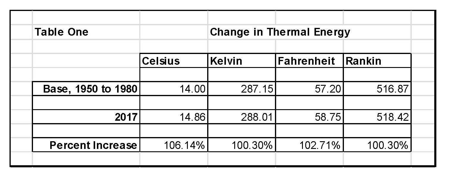
When we talk about climate (long term changes; centuries) or weather (short term changes; decades) local temperatures are going be in Celsius (C) in the EU and science, or degrees Fahrenheit (F) in America. The base temperature for the earth that NASA established is 14.00 C or 57.20 F; but these are both relative measures and do not tell us how much heat (thermal energy) is there. To know that we must use Kelvin (K) or Rankin (R) and that would be 287.150 K and 516.870 R all four of those numbers 14.00 C, 287.150 K 57.20 F, and 516.870 R are exactly the same temperature, just using a different base. But if the current temperature went from 14.00 C, to 14.860 C that is a 6.14% increase in C, an increase of 2.71% in F and an increase of .30% in K and R; so which one is real? The answer is .30% because Kelvin and Rankin are the only ones that measure the total increase in energy! Table One shows these relationships that we just discussed.

The next step is to plot Carbon Diode (CO2) from NOAA-ESRL and the estimated global temperature as published by NASS-GISS each month.  As can be seen in Table One It doesn’t really matter whether we would use Kelvin and Rankin since the increase in thermal energy is exactly the same either way; but we’ll use Kelvin as that is the accepted norm in the scientific community for determining the amount thermal energy in any object especially when looking at changes in temperature or measuring the thermal energy in any object.  There are other less known temperature scales that have specific purposes but they don’t really apply here in this subject.

The important thing is how much has the temperature actually gone up since we started to measure CO2 in the atmosphere? To show this graphically Chart 8 was constructed by plotting CO2 as a percent increase from when it was first measured in 1958, the Black plot, the scale is on the left and it shows CO2 going up about 30.0% from 1958 to May of 2018. That is a very large change as anyone would have to agree.  Now how about temperature, well when we look at the percentage change in temperature from 1958, using Kelvin, we find that the changes in global temperature are almost un-measurable. The scale on the right side had to be expanded 5 times (the range is 20 % on the left and 4% on the right) to be able to see the plot in the same chart in any detail. The red plot, starting in 1958, shows that the thermal energy in the earth’s atmosphere increased by .30%; while CO2 has increased by 30.0% which is 100 times that of the increase in temperature. So is there really a meaningful link between them that would give as a major problem?

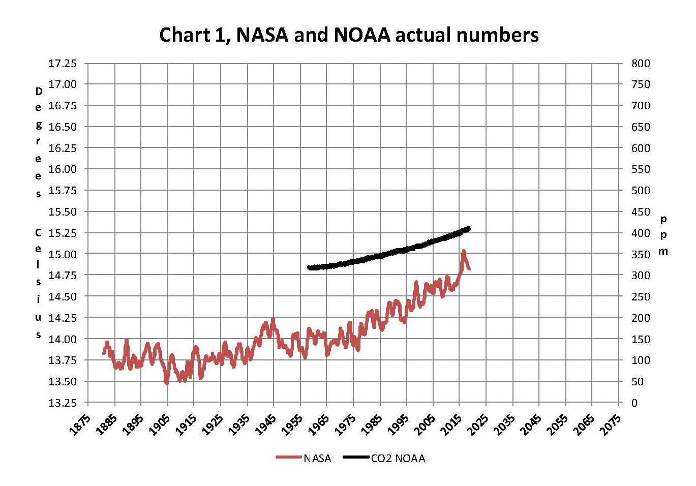
Chart 8 and all the rest of what is shown here in this paper are based on the following two data series. First NASA-GISS estimates of a global temperature shown as an anomaly (converted to degrees Celsius) as shown in their table Land Ocean Temperature Index (LOTI) and shown in Chart 1 as the red plot labeled NASA the scale for the temperatures is on the left. The NASA LOTI temperatures are shown as a 12 month moving average because of the very large monthly variations. Second NOAA-ESRL CO2 values in Parts per Million (PPM) which are shown in Chart 1 as a black plot labeled NOAA the scale for CO2 is shown on the right no change is required to the NOAA data set it is ready to use as is.

NASA published data is shown as an anomaly, but what is a temperature anomaly?  An anomaly is a deviation from some base value normally an average that is fixed. There were two problems with the system that NASA picked which were number one there is no “actual” global temperature and two since climate is a variable and always has been so there cannot be a real base to measure from. NASA known for its science and engineering expertise back in the day thought it could get around these issues and created a system to do so. First they developed a computer model which took the readings from all over the planet and made adjustments to them in software which they called homogenization and came up with the estimated global temperature. Second they picked the period 1950 to 1980 (30 years) and averaged the values found in that period and came up with 14.00 degrees Celsius and make that their base.  Lastly they took the calculated monthly temperature and subtracted the base from it which gave them the anomaly and multiplied the result by 100.

The problem is that both are arbitrary. Why pick 1950 to 1980 as the base period? Is there something special about that time frame? And as to a global temperature there is no such thing for many reasons like the earth faces the sun so one side is cool and onside it warm. Higher latitudes are cooler than the equator and higher elevations are cooler than lower. And finally there are many areas where there are no measurements taken. Therefore there is no one temperature only an artificial artifact solely dependent on the soundness of the software used to create that one temperature!

Chart 1 below is 100% accurate and based only on NASA and NOAA data as published.

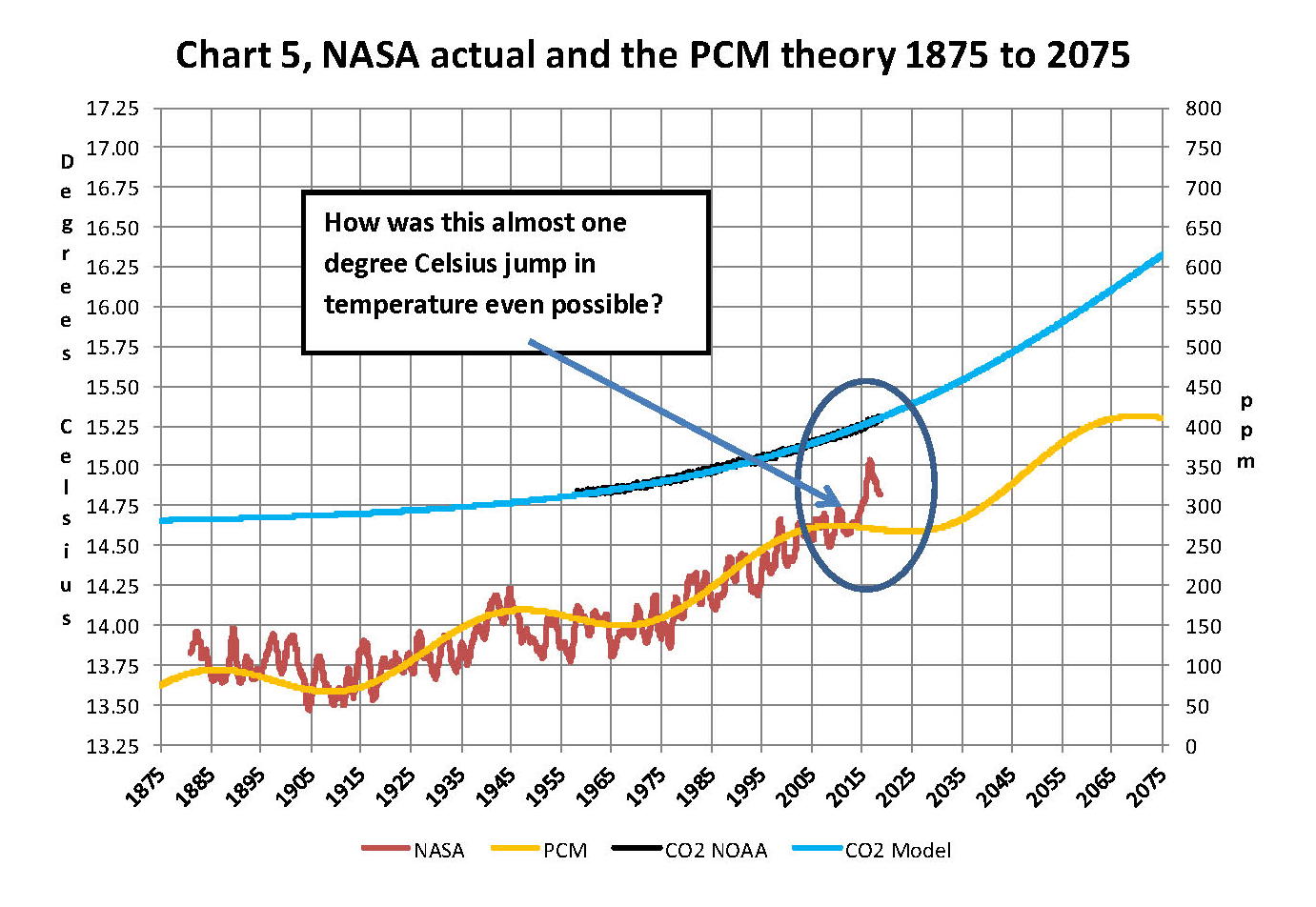
Now that we have a base to work with we are going to add to Chart 1 three things. The first is a trend line of the growth in CO2 since that is according to the government through NASA and NOAA the entire basis for climate change. That plot is superimposed over the black plot of the actual NOAA CO2 values as the cyan line labeled as the CO2 model and one can see there is a very good fit to the actual NOAA values so there should be no dispute about its validity, and it’s historically accurate.  This plot allows us to make projections to future global temperatures according to the projected level of CO2The second added item is James E. Hansen’s 1988 Scenario B data, which is the very core of the IPCC Global Climate models (GCM’s) and which was based on a CO2 sensitivity value of 3.0O Celsius per doubling of CO2. This plot is shown here in lavender and is from a presentation that Hansen showed congress in 1988 to help support the UN in setting up the International Panel on Climate Change (IPCC). This plot is labeled as Hansen Scenario B which Hansen stated was the most likely to happen based on his 1979 climate theories’.  The third item is the current plot of the most likely temperature of the planet based on the growth of CO2 published by the IPCC. This plot is shown in Red and is labeled as IPCC AR5 A2 as that is the table where the data was found. This plot is a GCM computer projection of the planets temperature based on the complex relationships developed by the IPCC primarily though NASA and NOAA.

It can be seen in Chart 2 that the lavender plot and the Hansen plot are very close from 1965 to around 2000. However there isn’t a good correlation between the growth in CO2 and the increase in the planets temperature, as shown in Chart 8. The CO2 is going up in a log function and the temperature was going up until 2000 then it plateaued from 2000 until 2014 where there was a mysterious spike up of .5 degrees Celsius just in time for COP21 in Paris. Then after CP21 was over the unexplained change in temperature started to come back down. The climate doesn’t make changes like what the NSA/NOAA data shows that would be weather if it even was real.

Chart 7 looks at the period from 2010 to 2020 so we can see where a change in CO2 of only a few ppm has caused a major change in the global temperature way beyond anything previously shown in any published NASA data. There are three ovals on Chart 7 one at the top of Chart 7 which is a black oval around the CO2 levels from 2010 to 2018 and it’s very obvious that there has been very little change, maybe 3 ppm a year Then at the bottom of Chart 7 is dark red oval around the NASA global temperature levels from 2013 to 2018 and its very obvious that there has been a sudden large change, almost .50 degrees Celsius in 3 years. There has never been such a large increase in temperature from such a small increase in CO2. By contrast the previous comparable period of the last part of 2010 through 2013 Blue oval shows about the same increase per year for CO2 but global temperature decreased.

An explanation is needed here as the NASA temperature plot in Chart 7 seems to show the jump in temperature in 2016 not 2015; this is a result of the very large jump in temperature shown by NASA. Since we are using a 12 month moving average and the increase occurred in only a few months it actually shifted the curve into 2016. The raw data for December 2012 was at a low of 14.44 degrees Celsius but by February 2016 the temperature was at a record high of 15.35 degrees Celsius a .91 degree Celsius increase, Red arrow. With the global temperature over 15.0 Celsius at COP21 in December 2015 at the Paris COP21 conference the climate accord was approved and the manipulation was a success. After COP21 the Fake Warming was no longer needed so we are now seeing a downward trend developing. The current temperature for June 2018 is 14.88 degrees Celsius.

In summary, the IPCC models were designed before a true picture of the world’s climate was understood. During the 1980’s and 1990’s CO2 levels were going up and the world temperature was also going up so there appeared to be correlation and causation. The mistake that was made was looking at only a ~20 year period when the real variations in climate  move in much longer cycles of centuries which can be observed in the NASA data but they were ignored for some reason.  By ignoring those actual geological trends and focusing only on CO2 the Global Climate Models will be unable to correctly plot global temperatures until they are fixed. Also the temperature data from 1850 to 1880 was dropped for some reason as it showed a lower temperature than would be expected. The lower temperatures’ in that period would have shown a shorter cycle they didn’t want shown.

A decade ago when I started looking at “climate” change the first thing I did was look at geological temperature changes since it is well known that the climate is not a constant; I learned that 53 years ago in my undergrad geology and climatology courses in 1964. The next paragraph explains currently observed patterns in climate related to this subject and is historical accurate.

Ignoring the last Ice Age which ended some 11,000 years ago when a good portion of the Northern hemisphere was under miles of ice the following observations give a starting point to any serious study on the subject of climate. First, there is a clear movement up and down in global temperatures with a 1,000 some year cycle going back at least 3,000 to 4,000 years; probably because of the apsidal precession of the earth’s orbit of about 20,000 years for a complete cycle. About every 10,000 years the seasons are reversed making the winter colder and the summer warmer in the northern hemisphere. 10,000 years from now the seasons will be reversed again. Secondly, there are also 60 to 70 year cycles in the Pacific and the Atlantic oceans that are well documented. These are known as the Atlantic Multi Decadal Oscillations (AMO) in the Atlantic and as La Nina and El Nino in the Pacific. Thirdly, we also know that there are greenhouse gases such as carbon dioxide that can affect global temperatures. Lastly the National Academy of Sciences (NAS) estimated that carbon dioxide had a doubling rate of 3.0O Celsius plus or minus 1.5O Celsius in 1979 when there were only two studies available and one for sure and maybe both were not peer reviewed.

The result of looking objectively at the three possible sources of global temperature changes was a series of equations based on these observations that when added together produced a sinusoidal curve that seemed to follow NASA published temperatures very closely when first developed in 2007, and modified a few years later when it was found the short and long cycles were related to multiples of Pi.  Since this curve was based on observed temperature patterns it was called a Pattern Climate Model (PCM) which has been described in previous papers and posts on my blog and since it is generated by “equations” many assume it is some form of least squares curve fitting, which it is not. It does seem to be related to ocean currents where the bulk of the planet’s surface heat is stored and cloud formation.

Chart 5 shows the PCM a composite of two cycles and CO2. There is a long trend, 1036.7 years with an up and down of 1.65O Celsius (.00396O C per year) we in the up portion of that trend. Then  there is a 69.1 year cycle that moves the trend line up and then down a total of 0.29O Celsius and we are now in the downward portion of that trend (-.01491O C per year), which will continue until around ~2035. Lastly, there is CO2 currently adding about .0079O Celsius per year so together they all basically wash out at -.0039O C per year, which matches the current holding pattern we were experiencing until 2014. After about 2035 the short cycle will have bottomed and turn up and all three will be on the upswing again duplicating what was observed in the 1980’s.  Note: the values shown here are only representative from what is in the model.

When using a 12 month running average for global temperatures up until 2014 the PCM model was within +/- .01 degrees of what NASA was publishing in their LOTI table since the early 1960’s as shown in Chart 5. Further the back projection of the PCM plot matched historical records and global temperatures going back past the time of Christ. It should also be considered that geologically CO2 levels have reached levels many times that of the current 400 ppm without destroying the planet so the current hysteria over the current very small numbers can only be explained by political science not real science.

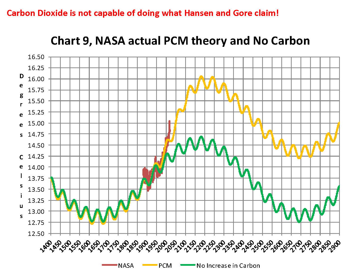
Lastly, Chart 9 shows what a plot of the PCM model, in yellow, would look like from the year 1400 to the year 2900. This plot matches reasonably well with recorded history and fits the current NASA-GISS table LOTI data, in red, very closely, despite homogenization.  I do understand that this PCM model is not based on physics but it is also not some statistical curve fitting. It’s based on two observed reoccurring patterns in the climate and a factor for CO2. These patterns can be modeled and when they are, you get a plot that works better than any of the IPCC’s GCM’s. If the real conditions that create these patterns do not change and CO2 continues to increase to 800 ppm or even 1000 ppm then this model will work well into the foreseeable future.  150 years from now global temperatures will peak at around 15.750 to 16.000 C and then they will be on the downside of the long cycle for the next ~500 years.

The overall effect of CO2 reaching levels of 1000 ppm or even higher will be about 1.50 C which is about the same as that of the long cycle.  The Green plot on Chart 9 shows the observed pattern with no change in CO2 from the pre-industrial era of ~280 ppm. CO2 cannot affect global temperatures more than 1.500 C +/- no matter what the ppm level of CO2 is. The reason being that the CO2 sensitivity value is not 3.00 per doubling of CO2 but less than 1.00 C per doubling of CO2 as shown in more current scientific work and it’s a logistics curve not a log curve.

The purpose of this post is to make people aware of the errors inherent in the IPCC models so that they can be corrected. 

The Obama administration’s “need” for a binding UN climate treaty with mandated CO2 reductions in Europe and America was achieved as predicted at the COP12 conference in Paris in December 2015. To support this endeavor NASA was forced to show ever increasing global temperatures that will make less and less sense based on observations and satellite data which will all be dismissed or ignored.  Within a few years the manipulation will be obvious even to those without knowledge in the subject, but by then it will be to late the damage to the reputation of science will have been done. Fortunately President Trump pulled us out of the bad agreement.

In closing keep this in mind. The current panic generated by the government using political science is that the current global temperature of around 15.0O Celsius is an increase of 7.14% from the 1960’s when the global temperature was 14.0O Celsius; and that does seem like a lot. However those views would be in error as the actual increase in thermal energy, as measured by temperature, would be only .35% because we must use Kelvin not Celsius when working with heat energy. When we use kelvin the temperature goes from 287.15O K to 288.15O K which is only .35% not 7.14% about 1/20 of what is implied by the IPCC. What the IPCC shows is not technically wrong as much as it is extremely misleading to anyone without a science background.


Sir Karl Raimund Popper (28 July 1902 – 17 September 1994) was an Austrian and British philosopher and a professor at the London School of Economics. He is considered one of the most influential philosophers for science of the 20th century, and he also wrote extensively on social and political philosophy. The following quotes of his apply to this subject.

If we are uncritical we shall always find what we want: we shall look for, and find, confirmations, and we shall look away from, and not see, whatever might be dangerous to our pet theories.

Whenever a theory appears to you as the only possible one, take this as a sign that you have neither understood the theory nor the problem which it was intended to solve.

… (S)cience is one of the very few human activities — perhaps the only one — in which errors are systematically criticized and fairly often, in time, corrected.


September Breaks all Records for Snow Fall Because Obviously Canadians Don’t Pay Enough in Global Warming Taxes to Make a Difference


COMMENT #1: Mr. Armstrong; I met you here in Edmonton years ago. I think you are the only analyst to have ever bothered to come up this far. I still read you as to many here. I just wanted to tell you that the snow is early and in Alberta, it looks like we will have crop failures because of it. I suppose it’s time to start moving south. Just have to convince the wife. The kids are out the door.

HK

COMMENT #2: Marty; you have a lot of readers here in Alberta. It has begun to snow here already and it has broken all records. I suppose Justin Trudeau will say it because the global warming tax is not high enough. That’s my bet for the excuse how taxes do not change anything.

All the best

JR

REPLY: Well you have a point. When the medieval doctors would bleed you to get the disease out and you died, the excuse was always they were too late to bleed you, never that they took too much blood. Obviously, this is all your fault. You are just not paying enough in global warming taxes and you insist on heating your home and driving to work. How dare you! So, what do you expect? You are responsible for changing millions of years of weather if not billions. The answer is obvious. You should stop working, live by candlelight, and kill a bunch of animals to stay warm – lol.

Yes, it was snowing late into June and now you are breaking historical records for snow in September. I am not a fan of the cold. I will pay for Global Warming thank you. Trudeau wants to just tax you to pay for his pension for the money does not go to anything really for the environment

Pentagon Warned President Bush Global Warming Was Bigger Threat Than Terrorism


A secret report by the US defense chiefs warned President Bush that Global Warming was such a great threat that it would destroy the United States and major European cities. They told the President that cities would sink beneath rising seas and Britain would be plunged into a “Siberian” climate by 2020. They warned that mega-droughts, famine, and widespread rioting will erupt across the world. The document warned that the planet would fall into anarchy and the nuclear threat would rise as countries then sought to defend themselves in the face of declining food, water, and energy supplies. Of course, the entire theory was that the ice caps melt and this the seas have to rise. NEVER did anyone ever do any historical investigation and they reduced everything to a single cause and effect. Evaporation or how ice ages were even created was NEVER a consideration.

I remember as a child going to Washington with my father when he would report at the Pentagon for some reason I never knew. I do remember walking down the halls with my father when I was less than 10 years old. I do remember people running around all serious with stacks of papers. After this report was leaked and published back in 2004 by the Guardian, it makes you wonder about how these people conduct long-range forecasts. I do not think London, New York, Tokyo, Hong Kong, or Sydney will sink below the waves. It is just another example of how one-dimensional analysis is our doom. We are now only two-years from 2020 when Britain was supposed to be the new Siberia. Get going! Your behind schedule!

The Washington Post tells everyone Climate Change is real because of Hurricane Florence – a Category 1 event. You really have to wonder why these newspapers put out such propaganda and make no effort to do any research. The list of North Carolina hurricanes where Florence hit prior to 1900 yields a list of 139 tropical cyclones/hurricanes. In fact, North Carolina was hit by 7 storms during 1893 ALONE!!!!! During 1893, BEFORE the combustion engine, that remains the record for the most hurricanes to hit North Carolina in a single season. On August 27th, 1893, a major hurricane which came to be known as the Sea Islands Hurricane that hit Georgia turned up through North Caroline killing they believe around 2,000 people. There was the category 3 Charleston Hurricane of 1893 and it came ashore near McClellanville, SC with maximum sustained winds near 120 mph.

It really does not take much of an effort to report the truth just for once. The worst hurricane season on record still remains 1893 before Global Warming. The 1893 Atlantic hurricane season had 12 tropical storms of which 10 became hurricanes. Then of the 10 hurricanes, FIVE became major hurricanes. Two of those storms kill over 2,000 people each. The 1893 season remains the most deadly storm season in American history. The second season on the list was the 1998 Atlantic hurricane season, where there were 4 Atlantic hurricanes that were active on the same day. The hurricane season is at its peak in August to October. Records before 1851 are really spotty. We do know that the Spanish Treasure Fleet of 11 ships were sunk in a hurricane during 1715, which is believed to be a category 4+.

Running this data through our system revealed a 4.3-year cycle of intensity. In other words, where there were 4 or more major hurricanes in that season. Then the pattern which emerges shows that there are typically back to back years of intensity.This was the case for 1893-1894, 1915-1916, 1932-1933, 1995-1996, 2004-2005, 2010-2011, and 2016-2017. It does strangely forecast that worst back-to-back hurricane season will be 2031-2032. That lines up with the peak in the Economic Confidence Model. Hm?

In fact, one of the major theories that may explain the disappearance of Roanoke Colony points to a major hurricane that completely destroyed the village. There is no evidence to prove the theory. In 1587, Raleigh dispatched a new group of 115 colonists to establish a colony on the Chesapeake Bay. Some argued that they were massacred by the Indians, but no bodies were ever found. It may be that a major storm approached and they took shelter with the Indians. Nobody has ever solved this mystery

Australia Drought Sends Kangaroos invading Cities


Kangaroos are invading the Capital of Australia as the drought has created a food shortage. The “roos” have been invading the cities and they like to feed precisely during Rush Hour. Here is one that decided to visit the sports match when the game was in motion.

It is quite a big threat down there thanks to a severe drought.

Red Tide & Blaming Farmers & Global Warming Yet it Conforms to Pi


If you ever live at the shore, one thing that crops up in 13-year cycles is what they call Red Tide. The traditional explanation I have always heard is that is caused by farming and the runoff of their pesticides that contaminate the water. I use to hear that in New Jersey and the same thing in Florida. It seems to be linked to the same people who promote Global Warming who want us to starve and stop driving to work. I would ask, where is the runoff from farmers when there are none in this area? It would go in one ear and out the other. It seemed to be more of an urban legend that has perpetuated by telling the same lie so many times it becomes just accepted truth.

To say the least, I was shocked to actually see an article in the local newspaper, Tampa Bay Times, explaining the issue and they were not blaming the farmers. There are scientists who are actually trying to figure out what causes a Red Tide and the research is untainted because they haven’t figured out a theory governments can use to justify more taxes. They are studying how the Earth is actually much more dynamic and globally connected than anyone has ever dared to image previously.

The subject of study is how the Sahara Desert may be to blame for environmental changes. It turns out that the Sahara Desert results in massive dust storms that are carried in the winds just as volcanic ash in the Pacific can create volcanic winters in New York City. The dust storms from the Sahara actually provide a vital nutrient source that fertilizes the rain forests in South America. They have been collecting the dust to track its movements all the way here in Florida.

What they have uncovered is that for about 100 days from spring through the fall, the winds in Africa pick up tiny dust particles from the desert and propel them high into the air and then carry them thousands of miles across the Atlantic Ocean. They travel up to 3 miles above the surface of the water. They have been landing in the Caribbean Sea and the Gulf of Mexico for millions of years. These dust storms have contributed to building Caribbean beaches and they have fed phytoplankton. They will even create beautiful sunsets off in Texas.

Scientists are still trying to understand the extremely complex ecosystem of the planet. They are not sure yet why patches of Red Tide algae suddenly multiply by the millions and turn the water the color of rust killing fish. These Red Tide blooms will actually begin typically 10 to 40 miles offshore. The currents and the wind move then closer to shore. The origin appears to be these clouds of dust that form and travel the same course as hurricanes. With satellite images, they can now actually visually see these massive dust storms originating in Africa.

Red Tide also takes place in the Pacific. What is interesting is how in California they have been using Red Tide claiming this is proof of Global Warming. The argument has been that the algae blooms during the period of warm water and thus instead of farmers, they blame people driving to work.

There, the Pacific Ocean undergoes what is called upwelling. Upwelling is the process when winds carry deep, cold nutrient-rich water to the surface of the ocean. This process of upwelling mixes with ocean currents making for an area rich in microbial and organismal diversity. There are three currents off the Pacific coast that impact this mixing that takes place. The first is the California Current (CC), which carries cold, oxygen and nutrient-rich water southward along the Pacific coast. The second is the California Undercurrent (UC), which originates from the Eastern Pacific near the equator and brings warm, saline, phosphate and oxygen-poor water northward. The final current is the Davidson Current (DC), which occurs in the fall and winter bringing current northward.

The Red Tide that hits San Diego produced night glowing algae that is beautiful. The cause of this unusual phenomenon was a tiny organism called Lingulodinium polyedrum which is a type of algae which is emerging cyclically but is also a Red Tide.

I have always sought to explore looking for ancient texts of contemporary accounts to help clarify cyclical trends. I came across Fray Diego Lopez de Collogudo, who was a Franciscan monk and historian in Yucatan, Mexico. Collogudo documented a massive fish kill that occurred in 1648. He described the following (translated from Spanish):

A short time later, in the city of Merida, for several days, especially in the evenings when the wind blows from the sea, came a foul odor that at times could barely be tolerated, as it penetrated all parts. No one knew the cause of the odor until a ship from Spain encountered a mountain of dead fish near the coast. Dead fish were heaped on shore, and this is where the foul odor emanated.

(id/ Lopez Collogudo, D., 1688. Historia de Yucatan. Publicaciones del H. Ayuntamento de Campeche. Campeche, Mexico.)

There was another first fish kill in the Gulf of Mexico chronicled by a government official which took place in 1792 in the city of Veracruz, Mexico. The official’s name was Lerdo de Tejada who reported the following from 10 November 1792 (translated from Spanish):

For several days now multitudes of dead fish have washed onto the beaches of Veracruz and some violent deaths have occurred to which were attributed to the sale of these fish. The governor decreed a ban on the sale of all types of fish from rivers and those fish from the sea could not be sold until the proper authorities inspected them. This same epidemic of dead fish occurred repeatedly in this same port. 

(id/ Lerdo de Tejada, M.M., 1850. Apuntes Historicos de la Heroica Ciudad de Veracruz. Imprenta de Ignacio Cumplido, C. Reeditados por la Oficina de Máquinas de la Secretar´ıa de Educación Pública, Mexico, 1940)

Personally, if I can find accounts of the same phenomenon centuries before fertilizers and driving to work, I think it is safe to presume we may just be dealing with a natural phenomenon that is more supported by the satellite images of dust storms that follow the same path as hurricanes. In this case, we may not even be dealing with something that is caused by climate change. I ran some preliminary Red Tide events into the computer and out popped the 8.6-year frequency and particularly intense period on 13-year cycles. Just interesting to say the least.

2016-18 Big Chill – NASA Confirms Global Cooling?


What I find really distasteful is how the media is so corrupt that all they want to do these days is to manipulate us into mindless drones. All we hear is Global Warming and they seem to be paid to push this just as they have done in Canada to tax each house $1,000+ to solve Global Warming? It should come as no surprise that the very same news source they have used for their Global Warming pitch has reported the greatest global two-year cooling event of the last century just occurred. Their data from February 2016 to February 2018 showed that the global average temperatures declined 0.56°C. The last two-year decline was 1982-1984 with a drop of 0.47°C, which took place during their favorite stint to justify global warming era. (see NASA Goddard Institute for Space Studies (dataset accessed 2018-04-11 at https://data.giss.nasa.gov/gistemp/).

Then we have the Global Warming crowd trying to dismiss the Big Chill claiming it is really Global Warming causing an increase in volatility of temperatures. Here we go again with FAKE NEWS data. The global temperatures are by no means becoming more volatile and if you run the data through a standard measurement we use in markets to gauge volatility, you are immediately confronted with the monthly global average temperatures since 2000 is only about 65% of what it was from 1880 to 1999. They simply refuse to just accept that there are cycles to EVERYTHING!!!!!!!!!!!!!!!!!!!!!!!!!!!!!!!!!!!!!!

Meanwhile, in South Australia has seen temperatures plunge 10 degrees making this the coldest September morning in 23 years and coldest morning this late in the year in more than 50 years of records. This corresponds to the snow in Africa confusing the animals completely. It would be nice if the news just reported the news for perhaps we just might prepare like Joseph warned the Pharaoh. With all this FAKE NEWS, they may with hindsight be responsible for the deaths of millions if we have a famine without preparation

Fake News is Unbelievable – When is Enough going to be Enough


A TV reporter is caught acting pretending the wind is so strong in Florence while two people in the background are casually walking by. Besi9des that, the wind is coming from behind him and he is acting as if he is fighting against the wind from from the opposite direction. Hurricane Florence was downgraded to Category 1 before it made landfall. Instead of reporting the truth, the media seems desperate for attention and viewership that they are exaggerating and outright reporting propaganda. The media is so intent upon handing the country back to Democrats, there is not a single piece of news that they are now turning it against Trump claiming Global Warming is the reason for Florence. We can’t even just get honest weather reports without a political slant and manipulation.


The Washington Post has used the Hurricane Florence as an excuse to turn it against Trump reporting he is “complicit” on climate change and this storm is basically all his fault. Surely if we just taxes every house $1,000 a year as in Canada for the Global Warming Tax storms like this would NEVER happen again is the implication.  The Post wrote:

YET AGAIN, a massive hurricane feeding off unusually warm ocean water has the potential to stall over heavily populated areas, menacing millions of people. Last year Hurricane Harvey battered Houston. Now, Hurricane Florence threatens to drench already waterlogged swaths of the East Coast, including the nation’s capital. If the Category 4 hurricane does, indeed, hit the Carolinas this week, it will be the strongest storm on record to land so far north.

President Trump issued several warnings on his Twitter feed Monday, counseling those in Florence’s projected path to prepare and listen to local officials. That was good advice.

Yet when it comes to extreme weather, Mr. Trump is complicit. He plays down humans’ role in increasing the risks, and he continues to dismantle efforts to address those risks. It is hard to attribute any single weather event to climate change. But there is no reasonable doubt that humans are priming the Earth’s systems to produce disasters.


1944 The Great Hurricane Worst to Hit New Jersey

I grew up in New Jersey and had a family friend we called an uncle who lived on the beach. Twice he lost his house that was swept out to sea in 1955 and again in 1960. The press is acting like there have never been storms like we have today and this is all because of Global Warming. The first three of the top 12 worse storms to hit New Jersey took place in 1804, 1806, and 1821 followed by 1903. All predate the combustion engine and CO2 emissions.

Then there was the famous Spanish Treasure Ship fleet where all 11 ships were sunk in a Hurricane of 1715. Hello! These are before they claim Global Warming began! The list of the worst storms from the 19th century forward is 1804, 1806, 1821, 1900, 1903, 1938, 1944, 1955, 1960, 1999, 2011, and 2012. The worst hurricane was 1900 insofar if the measurement is the number of people dead which reached 12,000 in Galveston, Texas.

After the hurricane of 2017 that was to hit my area of Florida, CNN had people scared to the point they were, according to the Associated Press, paying $1,725 for a flight from Fort Myers to Charlotte, North Carolina ahead of Irma. People around here hate CNN for their coverage last year. They staged things like standing in water while the film crew was not anywhere close to the same depths. You have to figure Anderson Cooper was also probably standing with his knees bent to make it look even deeper. They are trying so hard to manufacture news it has become outrageous.

CNN claimed there would be a storm surge of 7 to 10 feet. I live right on the beach and it reached maybe one foot. The other day, there were two young girls sitting at the next table and all they talked about was FAKE NEWS and how they will not even watch TV anymore. If they get caught manufacturing this nonsense, can we believe anything anyone says now in mainstream media left or right?

Snowing in Africa – Wow


COMMENT: Well it’s not hailstones down here. It is snow. Even the animals are confused.

REPLY: Well it certainly looks very dramatic from here in Florida.

Will Global Warming Sink the Netherlands?


A friend of mine was taking a class in geography in university for the credits. The professor was all about brainwashing the class about Global Warming. The pitch was that with reducing air pollution from cars, it would be possible to save the Netherlands otherwise the seas will rise and the country will vanish from the face of the earth.

I find it really incredible how these people promote that everything on the planet is somehow our fault. Most of the ancient city of Alexandria, Egypt, from the time of Cleopatra is under water. Sure, that must have been caused by too many chariots and the farting of horses. Then there is the discovery of ancient sea fossils in the middle of Australia which shows that obviously, Australia was once under water. Dinosaur-age fossilized remains of extremely tiny organisms that are found in the sea have been discovered in the center of the arid Australian desert. This confirms that this area was, at least for a short time, under by sea water some 40 million years before Australia’s large inland sea existed.

I grew up in New Jersey. One of the few memories I have as a child was going down to the clay pits in search of dinosaurs since they had found one in the area. But they also found ancient sea creatures. During the Precambrian period, New Jersey was covered by a shallow sea that was home to stromatolite forming bacteria. During the early part of the Paleozoic, New Jersey was still under water. Fossils of various sea creatures were discovered in New Jersey. The state was home to creatures like brachiopods and trilobites. By the Silurian period, the northern part of the state was home to a river system. Sea levels rose and fell throughout the remainder of the state’s Paleozoic rock record long before people existed. There are no local rocks of Carboniferous or Permian age and then during the Triassic, the state became a terrestrial ecoregion. Then there were local lakes which became the home to various crustaceans. On land, dinosaurs left behind footprints and continued to do so into the Jurassic period. Much of the state was covered by sand which became known as the Pinelands.

The rise and fall of land have been going on for millions of years. It is part of the ecosystem itself and we are a bunch of narcissists to think that we are somehow even capable of changing the climate. We are no more than a flea on the back of a dog that can be shaken off when we become too annoying. When my friend texted me what the professor said that if we stopped driving our cars we could save the Netherlands, I texted back the ancient source I had read back in school.

There was a Greek geographer and explorer by the name of Pytheas of Massalia, but no copies of this work have survived. Nonetheless, we have others who have quoted Pytheas who recorded an account of the Low Countries, or what we call the Netherlands.  Pytheas passed the Low Countries on his way to Heligoland around c. 325 BC.  He wrote that “more people died in the struggle against water than in the struggle against men”. This is our earliest account of the region. Then we have the Roman author Pliny from the 1st century AD who wrote:

There, twice in every twenty-four hours, the ocean’s vast tide sweeps in a flood over a large stretch of land and hides Nature’s everlasting controversy about whether this region belongs to the land or to the sea. There these wretched peoples occupy high ground, or manmade platforms constructed above the level of the highest tide they experience; they live in huts built on the site so chosen and are like sailors in ships when the waters cover the surrounding land, but when the tide has receded they are like shipwrecked victims. Around their huts they catch fish as they try to escape with the ebbing tide. It does not fall to their lot to keep herds and live on milk, like neighboring tribes, nor even to fight with wild animals, since all undergrowth has been pushed far back.

Going back about 2,000 years ago, much of the Netherlands was covered by extensive peat swamps. The coastal dunes formed a natural embankment which prevented the swamps from draining. The first inhabitants were attracted to the rich soil compared to the peat swamps and sandy soil. They appear to have begun to protect themselves against floods by constructing their homes on artificial hills they created of which Pliny wrote about. Archeological evidence suggests that there was a cycle to the region between 500BC and 700AD where there were periods of habitation and abandonment as the sea level rose and fell.

It was not until the 9th century when the sea level rose again which forced people to raise their artificial hills higher. These small hills began to be connected forming villages and they began to construct dikes when communities could act in unison. It was not until after 1000AD that the population began to grow dramatically. This created more labor but a demand for more land. This is when we see the construction of dikes become more widespread. By 1250 most dikes had been connected into a continuous sea defense.

The Edict of Expulsion was a royal decree issued by King Edward I (1272-1307) of England on July 18th, 1290, expelling all Jews from the Kingdom of England. Why? The Jews were the king’s personal property, and he was free to tax them at will whereas British citizens could not be taxed without their consent which was obtained from Parliament. Edward I borrowed extensively from the Jews and taxes them to the point that they were no longer a source of revenue. He then expelled them and they were not allowed to take their property so it was the final confiscation to fund his war with France. Meanwhile, it was Philip IV of France who seized the Knights Templar, the Catholic Church moving it to Avignon installing a French Pope, and confiscating the assets of Italian bankers who were lending money to Edward I. This contributed to the first migration of the Jews to the Low Countries.

Sephardic Spanish Jews had once constituted one of the largest and most prosperous Jewish communities in the world and were regarded as the unquestioned leader of the Jewish world. During this period Sephardic Spanish Jews ended definitively with the anti-Jewish riots of 1391 about 100 years after the 1290 expulsion from England. Then about 100 years later, there was in Spain the Alhambra Decree of 1492 against the Jews. It seems that every time society could not repay the Jewish bankers,  the borrowers suddenly discovered they were OMG Jewish. Consequently, the majority of Jews in Spain around 200,000 converted to Catholicism after the Alhambra Decree. Those who refused were forced into exile and migrated to the Netherlands where they began insurance and trading of commodities, bonds, and stocks in Amsterdam.

So to me, to even listen to some university professor claim that we can save the Netherlands by reducing CO2, I just cannot believe we have such idiots who know nothing and ignore history profess to students what amounts to just propaganda. And they want tens of thousands of dollars annually per student to be brainwashed. Unbelievable!

UPDATE 11:00pm Hurricane Florence: Hunkering Down – Maximum Winds Dropped to 90mph – With Overnight Livestream…


Here’s the latest advisory from the National Hurricane Center. At 1100 PM EDT (0300 UTC), the center of the eye of Hurricane Florence was located by NOAA Doppler radar and an Air Force Reserve Hurricane Hunter aircraft near latitude 34.0 North, longitude 76.8 West. 50 miles south of Moorehead City, 60 miles east-south-east of Wilmington, North Carolina. Florence is moving toward the northwest near 6 mph (9 km/h).

Data from the Hurricane Hunter aircraft, coastal surface observations, and NOAA Doppler radar indicate that maximum sustained winds are near 90 mph (150 km/h) with higher gusts. Little change in strength is expected before Florence core moves inland on Friday.

A turn toward the west-northwest and west at a slow forward speed is expected through Friday, followed by a slow west-southwestward motion Friday night and Saturday. On the forecast track, the center of Florence is expected to move inland across extreme southeastern North Carolina and extreme eastern South Carolina Tonight, Friday and Saturday. Florence will then recurve across the western Carolinas and the central Appalachian Mountains early next week.

STORM SURGE: The combination of a dangerous storm surge and the tide will cause normally dry areas near the coast to be flooded by rising waters moving inland from the shoreline. The water has the potential to reach the following heights above ground:

  • Cape Fear NC to Cape Lookout NC: 7-11 ft, with locally higher amounts in the Neuse, Pamlico, Pungo, and Bay Rivers
  • Cape Lookout NC to Ocracoke Inlet NC: 6-9 ft
  • South Santee River SC to Cape Fear NC: 4-6 ft
  • Ocracoke Inlet NC to Salvo NC: 4-6 ft
  • Salvo NC to Duck NC: 2-4 ft
  • Edisto Beach SC to South Santee River SC: 2-4 ft

[National Hurricane Center]

.

For those who are in the path of the storm, there comes a time when all options are removed and you enter the “Hunkering Down” phase.  You’re there now. This storm is going to last for quite a while; and the backside storm surge has the potential to be much larger over time.  This is going to be a long-duration event.

When the winds reach around 40mph, the utility company will likely, proactively, shut down the power.  This makes things a heck of a lot safer in the aftermath; and much easier and safer during the rebuild.  It is almost a guarantee you did not lose power due to damage from the storm but rather because of proactive measures from your power company. Do not expect the power to be turned back on until it is safe.

Hurricanes can be frightening; downright scary.  There’s nothing quite like going through a few to reset your outlook on just how Mother Nature can deliver a cleansing cycle to an entire geographic region.   The sounds are scary, especially in the dark.  Try to stay calm despite the nervousness.  Telephone and power poles, yes, even the concrete ones, can, and likely will, snap like toothpicks.  Trees will bend and break; the sounds are dramatic.

There’s a specific sound when you are inside a hurricane that you can never forget.  It ain’t a howl, it’s a roar.  It is very unique sound in depth and weight.  Yes, within a hurricane wind has weight.  Stay clear of windows and doors.  That scary roar sounds like it won’t ever quit…. it will… eventually; but at the time you are hunkering down, it doesn’t seem like it will ever end.

A constant and pure rage of wind that doesn’t ebb and flow like normal wind and storms. Hurricane wind is heavy, it starts and stays; sometimes for hours.  Relentless, it just won’t let up.  And then, depending on her irrelevant opinion toward your insignificant presence, hopefully she stops.

Then silence.  No birds. No frogs. No crickets. No sound.

Nature goes mute.  It’s weird.

We have no idea how much ambient noise is around us, until it stops.

Oh, if she wants, she’ll keep dumping buckets on you as she wanders away.  Buckets. Not pails, garbage can sized buckets.  After the scour, yup, nature too has a rinse cycle.

If your town, city or hamlet is not underwater, there will be convoys coming to construct a pre-planned electricity grid recovery process.  Convoys from every city, town and state from the east-coast to the mid-west.  A glorious melding of dirty fingernails all arriving for the meet-up.   Depending on your proximity to the bigger picture objectives at hand, you will cherish their arrival.

But first, there will be an assessment.  The convoys will stage at pre-determined locations using radios for communication. Street-by-street everything needs to be evaluated prior to thinking about beginning to rebuild a grid.  Your patience within this process is needed; heck, it ain’t like you’ve got a choice in the matter…. so just stay positive.

Meanwhile, you might walk outside and find yourself a stranger in your neighborhood.

It will all be cattywampus.

Trees gone, crap everywhere, if you don’t need to travel, DON’T.

I mean CRAP e.v.e.r.y.w.h.e.r.e.

Stay away from power-lines.

Be entirely prepared to be lost in your own neighborhood and town for days, weeks, and even months.  Unknown to you – your subconscious mind is like a human GPS mapping system.  When that raging Florence takes away the subconscious landmarks I guarantee you – you are gonna get lost, make wrong turns, miss the exit etc.

It’s kinda funny and weird at the same time.

Your brain is wired to turn left at the big oak next to the Church, and the road to your house is likely two streets past the 7-11 or Circle-k. You don’t even notice that’s how you travel around town; that’s just your brain working – it is what it is.

Well, now the big oak is gone; so too is the Circle-K and 7-11 signs.  Like I said, everything is cattywampus.  Your brain-memory will need to reboot and rewire.  In the interim, you’re gonna get lost… don’t get frustrated.

No street signs. Likely no stop signs.  No traffic lights.

Remember, when it is safe to drive, every single intersection must be treated like a four-way stop…. and YOU ARE GOING TO HAVE TO PAY ATTENTION.  Even the major intersections.

You’ll need to override your brain tendency to use memory in transit.  You’ll need to pay close attention and watch for those who ain’t paying close attention.  Travel sparingly, it’s just safer.

Check on your-self first, then your neighbors. It don’t matter if you’ve never said a word to the guy in the blue house before.  It ain’t normalville now.

Break out of your box and check on the blue house down the street too.  In the aftermath, there’s no class structure.  Without power, the big fancy house on the corner with a pool is just a bigger mess.  Everyone is equally a mess.

The first responders in your neighborhood are YOU.

You, the wife, your family, Mrs. Wilson next door; Joe down the street; Bob’s twin boys and the gal with the red car are all in this together.  If you don’t ordinarily cotton to toxic masculinity you will worship it in the aftermath of a hurricane.  Git-r-done lives there.

Don’t stand around griping with a 40′ tree blocking the main road to your neighborhood.  Figure out who’s got chainsaws and set about clearing the road.  If every neighborhood starts clearing their own roadways, the recovery crews can then move in for the details.

Stage one focuses on major arteries… then secondary… then neighborhood etc.  It’s a process.  Oh, and don’t get mad if your fancy mailbox is ploughed-over by a focused front end loader who is on a priority mission to clear a path.  Just deal with it.

Phase-1 recovery is necessarily, well, scruffy…. we’re just moving and managing the mess; not trying to clean it up yet.  It’ll be ok.

Keep a joyous heart filled with thankfulness; and if you can’t muster it, then just pretend. Don’t be a jerk.  You will be surrounded by jerks….  elevate yourself.  If you need to do a few minutes of cussing, take a walk.  Keep your wits about you and stay calm.

Now, when the recovery teams arrive…. If you pass a line-man, pole-digger or crew say thanks.  Just simple “thanks”.  Wave at them and give them a thumbs-up. No need to get all unnecessarily familiar, a simple “thank you for your help” will generally suffice.  You know, ordinary people skills.

Many of these smaller crews will be sleeping in cots, or in their trucks while they are working never-ending shifts.  If you eventually start getting power back, and see a crew in a restaurant, same thing applies… “thanks guys”.  If you can pay their tab, do it.  If you can pay their tab without them knowing, even better.

Same goes for the tanker truckers. The convenience stores with gas pumps are part of the priority network.  Those will get power before other locales without power.  Fuel outlets are a priority.  Hospitals, first responders, emergency facilities, fuel outlets, then comes commercial and residential.

Remember, you are the first responder for your neighborhood.  Don’t quit.

Recovery is a process.  Depending on the scale of the impact zone, the process can take days, weeks and even months.  Take care of your family, friends and neighborhood, and generally make a conscious decision to be a part of any needed solution.

It’ll be ok.

It might be a massive pain in the a**, but in the end, it’ll be ok.

√Andrew

√Jeanne

√Frances

√Ivan

√Charley

√Irma

Keep a good thought.  Who knows, we might even end up shaking hands.

It’ll be OK.  Promise.