Posted originally on the CTH on October 8, 2024 | Sundance
This is a little bit unusual, and I don’t generally recommend going to a bizarro leftist narrative article for full review; however, in this case it is worth it.
Politico has written an article about FEMA Administrator Deanne Criswell, saying disinformation about the federal government response to Hurricane Helene, “is absolutely the worst I have ever seen,” Criswell told reporters on a Tuesday morning call. “It’s creating distrust in the federal government, but also the state government, and we have so many first responders that have been working to go out and help these communities,” she added. {link}
However, if you go read the article fraught with pearl-clutching and protestation, you might curiously discover there is not a single citation for any claimed “disinformation.” {SEE HERE} It is very odd to see FEMA and by extension Politico in their defense, claiming that massive disinformation is running rampant, and yet they do not cite a single example of the disinformation they claim to exist. Seriously, no joke – GO LOOK.
If you are an intellectually honest observer of government, you are left with the question: where is this disinformation you speak of?
Most of the shared examples of FEMA’s failures have been with full citation, presented with factual information – raw source attribution and audio/visuals of FEMA officials on the ground in Eastern Tennessee and Western North Carolina to bolster the claims. In short, all the claims against FEMA are specifically cited; however, all of the deflective justifications and denials are not.
Perhaps this is simply the state of current federal government. Whereby, thousands of individual citizens are giving real-time examples of what FEMA is doing and not doing, while FEMA (from DC) claims all of the citations and examples are “disinformation.”
It is all very Orwellian, and reminds me of something:
“Alice: Would you tell me, please, which way I ought to go from here?
The Cheshire Cat: That depends a good deal on where you want to get to.
Alice: I don’t much care where.
The Cheshire Cat: Then it doesn’t much matter which way you go.
Alice: …So long as I get somewhere.
The Cheshire Cat: Oh, you’re sure to do that, if only you walk long enough.”
Put another way, the people on the ground are telling the truth about the current state of affairs. The interests of FEMA are antithetical to the truth, so they label the truth “disinformation.” And that’s that.
Posted originally on the CTH on August 29, 2023 | Sundance
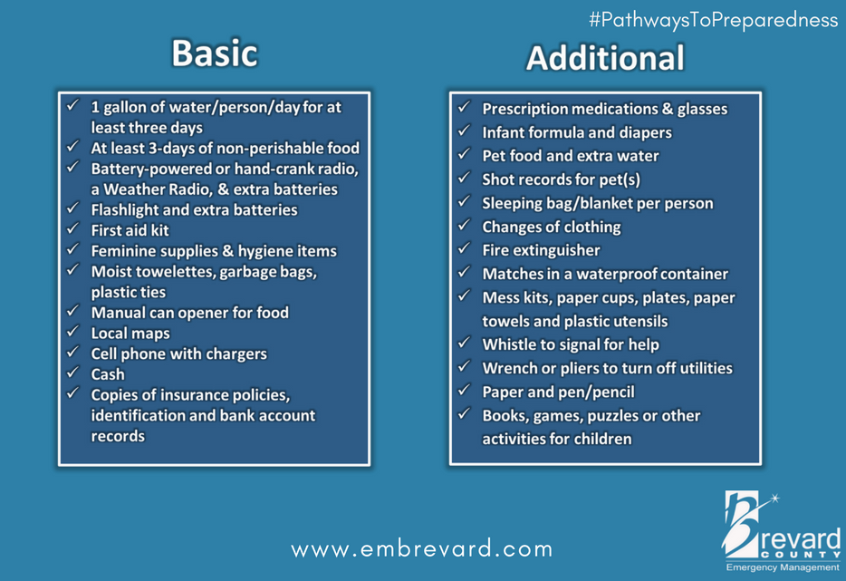
What follows is the #1 requested information by those who nervously anticipate the arrival of their first Hurricane experience.
As many long-time readers will know, we do have a little bit more than average experience dealing with the aftermath of hurricanes. I ain’t no expert in the before part; you need to heed the local, very local, professionals who will guide you through any preparation, and neighborhood specific guidelines, for your immediate area.
But when it comes to the ‘after part’, well, as a long-time CERT recovery member perhaps I can guide you through the expectation and you might find some value. Consider this little word salad a buffet, absorb what might be of value pass over anything else.
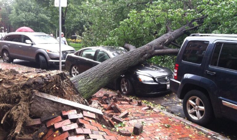
A category 3+ storm can erase structures, buildings and familiar landscape. Idalia is expected to be similar in forward speed to Hurricane Charley which impacted the SW coast of Florida in 2004, but the storm itself will be bigger, wider and carry a larger eyewall. Some moderate coastal topography will likely change in the 60-mile-wide area of immediate impact/landfall.
Some infrastructure failure should be anticipated, and it will take weeks for restoration. The coastal communities are the most vulnerable; however, the inland impact of this specific storm will be much more significant as the large storm continues unimpeded until the entire eye-wall crosses onto land.
That means communities inland all the way to Georgia and South Carolina could feel hurricane force winds, possibly for several hours. That scale of sustained wind energy will snap power poles and reinforced concrete.
As the backside of the storm then reverses the energy direction, any already compromised structures may not withstand the additional pressure. In many cases the backside of the storm is worse than the front. If you are inland, prepare yourself for a long duration of extensive wind damage followed by an extended power outage.
For those who are in the path of the storm, there comes a time when all options are removed, and you enter the “Hunkering Down” phase. You’re just about there now.
Fortunately, just like Charley, this particular hurricane will move fast and that might mitigate some of the coastal storm surge (only one part of one tidal cycle). However, in totality from impact through recovery this is going to be a long-duration event.
When the sustained winds reach around 45mph most emergency services stop. This makes things a heck of a lot safer in the aftermath; and much easier and safer during the rebuild.
♦ Hurricanes can be frightening; downright scary. There’s nothing quite like going through a few to reset your outlook on just how Mother Nature can deliver a cleansing cycle to an entire geographic region.
The sounds are scary. Try to stay calm despite the nervousness. Telephone and power poles, yes, even the concrete ones, can, and likely will, snap like toothpicks. Trees will bend and break. When the roof shingles are peeling off, it sounds like horses running across your roof. The sounds are dramatic.
There’s a specific sound when you are inside a hurricane that you can never forget. It ain’t a howl, it’s a roar. It is very unique sound in depth and weight. Yes, within a hurricane wind has weight. Stay clear of windows and doors, and within an interior room of the house or apartment if possible. That scary roar sounds like it won’t ever quit…. it will… eventually; but at the time you are hunkering down, it doesn’t seem like it will ever end.
A hurricane wind is a constant and pure rage of wind that doesn’t ebb and flow like normal wind and storms. Hurricane wind is heavy, it starts, builds and stays; sometimes for hours. Relentless, it just won’t let up. The constant rage is fueled by simultaneous surges inside it. Just like the water that fuels her, Idalia will deliver a rage of wind energy that has surges within the relentless force.
And then, suddenly, depending on Idalia’s irrelevant opinion toward your insignificant presence, it will stop. Judging by the forward speed the hurricane force wind will likely last around 2 to 3 hours before it stops.
Then silence. No birds. No frogs. No crickets. No sound.
Nature goes mute. It’s weird.
We have no idea how much ambient noise is around us, until it stops.
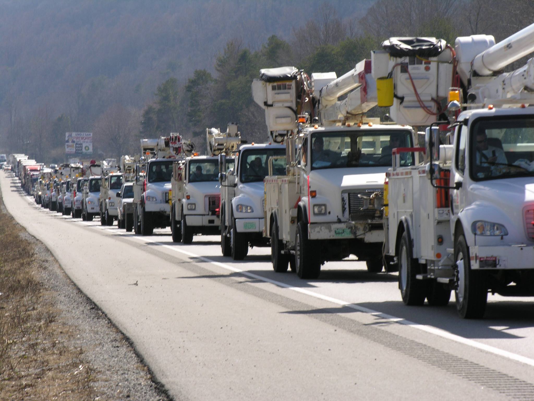
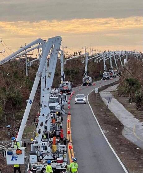
Due to the speed of the storm, there will be convoys coming to construct a pre-planned electricity grid recovery process even before nightfall tomorrow.
Convoys from every city, town and state from the east-coast to the mid-west. A glorious melding of dirty fingernails all arriving for the meet-up.
Depending on your proximity to the bigger picture objectives at hand, you will cherish their arrival.
But first, there will be an assessment.
The convoys will stage at pre-determined locations using radios for communication. Most cell phone services will likely be knocked out. Recovery teams will begin a street-by-street review; everything needs to be evaluated prior to thinking about beginning to rebuild a grid. Your patience within this process is needed; heck, it ain’t like you’ve got a choice in the matter…. so just stay positive.
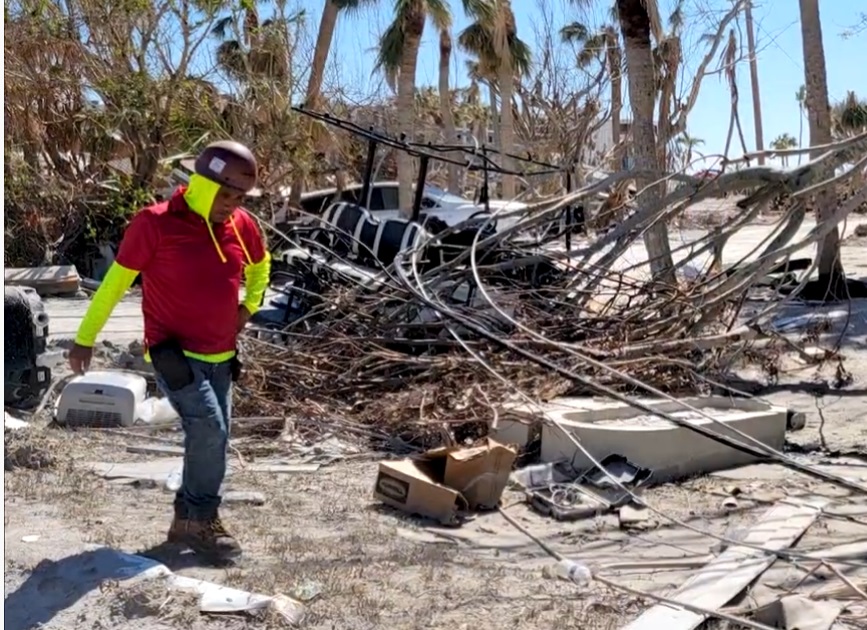
Meanwhile, you might walk outside and find yourself a stranger in your neighborhood.
It will all be cattywampus.
Trees gone, signs gone, crap everywhere, if you don’t need to travel, DON’T.
I mean CRAP e.v.e.r.y.w.h.e.r.e.
Stay away from power-lines.
Try to stay within your immediate neighborhood for the first 36-48 hours. Keep the roadways and main arteries clear for recovery workers, power companies and fuel trucks.
Be entirely prepared to be lost in your own neighborhood and town for days, weeks, and even months. Unknown to you – your subconscious mind is like a human GPS mapping system. When that raging Idalia takes away the subconscious landmarks I guarantee you – you are gonna get lost, make wrong turns, miss the exit etc.
It’s kinda funny and weird at the same time.
Your brain is wired to turn left at the big oak next to the Church, and the road to your house is likely two streets past the 7-11 or Circle-k. You don’t even notice that’s how you travel around town; that’s just your brain working – it is what it is.
Well, now the big oak is gone; so too is the Circle-K and 7-11 signs. Like I said, everything is cattywampus. Your brain-memory will need to reboot and rewire. In the interim, you’re gonna get lost… don’t get frustrated.
No street signs. Likely no stop signs. No traffic lights.
Remember, when it is safe to drive, every single intersection must be treated like a four-way stop…. and YOU ARE GOING TO HAVE TO PAY ATTENTION. Even the major intersections.
You’ll need to override your brain tendency to use memory in transit. You’ll need to pay close attention and watch for those who ain’t paying close attention. Travel sparingly, it’s just safer.
Check on your-self first, then your neighbors. It don’t matter if you’ve never said a word to the guy in the blue house before. It ain’t normalville now.
Break out of your box and check on the blue house down the street too. In the aftermath, there’s no class structure. Without power, the big fancy house on the corner with a pool is just a bigger mess. Everyone is equally a mess.
The first responders in your neighborhood are YOU.
You, the wife, your family, Mrs. Wilson next door; Joe down the street; Bob’s twin boys and the gal with the red car are all in this together. If you don’t ordinarily cotton to toxic masculinity, you will worship it in the aftermath of a hurricane. Git-r-done lives there.
Don’t stand around griping with a 40′ tree blocking the main road to your neighborhood. Figure out who’s got chainsaws, who knows how to correctly use them, and set about safely clearing the road. If every neighborhood starts clearing their own roadways, the recovery crews can then move in for the details.
Stage one focuses on major arteries… then secondary… then neighborhood etc. It’s a process. Oh, and don’t get mad if your fancy mailbox is ploughed-over by a focused front end loader who is on a priority mission to clear a path. Just deal with it. Those same front-end loaders will also be removing feet of sand from coastal roads. Don’t go sightseeing… stay in your neighborhood.
For the first 36-48 hours, please try to stay close to home, in your neighborhood. Another reason to stay close to home is the sketchy people who can sometimes surface, looters etc. Staying close to home and having contact with your neighbors is just reasonable and safer.
Phase-1 recovery is necessarily, well, scruffy…. we’re just moving and managing the mess; not trying to clean it up yet. It’ll be ok. There are going to be roofing nails everywhere, and you will likely get multiple flat tires in the weeks after the hurricane.
After this storm half of the people living near the impact zone are going to fit into two categories, two types of people: (1) those with a new roof; or (2) those with a blue roof (tarp).
Keep a joyous heart filled with thankfulness; and if you can’t muster it, then just pretend. Don’t be a jerk. You will be surrounded by jerks…. elevate yourself. If you need to do a few minutes of cussing, take a walk. Keep your wits about you and stay calm.
Now, when the recovery teams arrive…. If you are on the road and there’s a convoy of utility trucks on the road, pull over. Treat power trucks and tanker trucks like ambulances and emergency vehicles. Pull over, give them a clear road and let them pass.
When everyone gets to work, if you see a lineman, pole-digger or crew say thanks. Just simple “thanks”. Wave at them and give them a thumbs-up. No need to get unnecessarily familiar, a simple: “thank you for your help” will suffice. You know, ordinary people skills. The stuff that was common before the internet.
Many of these smaller crews will be sleeping in cots, or in their trucks while they are working never-ending shifts. Some will be staging at evacuation shelters, likely schools and such. The need to shelter people and recovery crews might also delay the re-opening of schools.
Once you eventually start getting power back, if you see a crew in a restaurant, same thing applies… “thanks guys”. If you can pay their tab, do it. If you can pay their tab without them knowing, even better.
Same goes for the tanker truckers. The convenience stores with gas pumps are part of the priority network. Those will get power before other locales without power. Fuel outlets are a priority. Fuel is the lifeblood of recovery. Hospitals, first responders, emergency facilities, fuel outlets, then comes commercial and residential.
Remember, this is important – YOU are the first responder for your neighborhood. Don’t quit. Recovery is a process. Depending on the scale of the impact zone, the process can take days, weeks and even months.
Take care of your family first; then friends and neighborhood, and generally make a conscious decision to be a part of any needed solution.
Pray together and be strong together. It might sound goofy to some, but don’t be bashful about being openly thankful in prayer.
It will be ok.
It might be a massive pain in the a**, but in the end, it’ll be ok.
Posted originally on the CTH on August 30, 2023 | Sundance
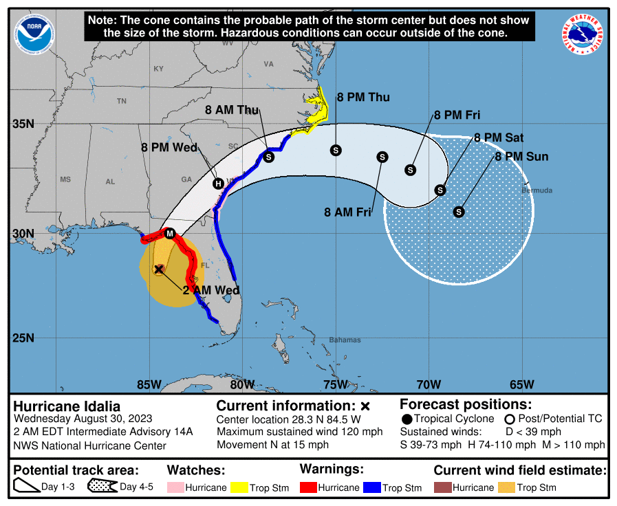
The time for preparations and/or evacuation decisions is past. This is pure hunker down time right now. Those in the immediate impact zone of Hurricane Idalia will see rapidly deteriorating weather conditions over the next few hours. Landfall expected at sunrise Wednesday.
Idalia will remain at hurricane strength throughout Georgia and likely into South Carolina. There will be a large swath of area impacted. There will be power outages and severe disruptions in all three states throughout the day today.
At 200 AM EDT (0600 UTC), the center of Hurricane Idalia was located near latitude 28.3 North, longitude 84.5 West. Idalia is moving toward the north near 15 mph (24 km/h). A northward to north-northeastward motion is expected through morning, with Idalia’s center forecast to reach the Big Bend coast of Florida this morning. After landfall, Idalia is forecast to turn toward the northeast and east-northeast, moving near or along the coasts of Georgia, South Carolina, and North Carolina late today and Thursday.
Hurricane Hunter aircraft data indicate that maximum sustained winds have increased to near 120 mph (195 km/h) with higher gusts. Idalia is a category 3 hurricane on the Saffir-Simpson Hurricane Scale. Additional strengthening is forecast, and Idalia is forecast to become a category 4 hurricane before it reaches the Big Bend coast of Florida this morning. Idalia is likely to still be a hurricane while moving across southern Georgia, and possibly when it reaches the coast of Georgia or southern South Carolina late today. (more)
What follows is the #1 requested information by those who nervously anticipate the arrival of their first Hurricane experience.
As many long-time readers will know, we do have a little bit more than average experience dealing with the aftermath of hurricanes. I ain’t no expert in the before part; you need to heed the local, very local, professionals who will guide you through any preparation, and neighborhood specific guidelines, for your immediate area.
But when it comes to the ‘after part’, well, as a long-time CERT recovery member perhaps I can guide you through the expectation and you might find some value. Consider this little word salad a buffet, absorb what might be of value pass over anything else.
A category 3+ storm can erase structures, buildings and familiar landscape. Idalia is expected to be similar in forward speed to Hurricane Charley which impacted the SW coast of Florida in 2004, but the storm itself will be bigger, wider and carry a larger eyewall. Some moderate coastal topography will likely change in the 60-mile-wide area of immediate impact/landfall.
Some infrastructure failure should be anticipated, and it will take weeks for restoration. The coastal communities are the most vulnerable; however, the inland impact of this specific storm will be much more significant as the large storm continues unimpeded until the entire eye-wall crosses onto land.
That means communities inland all the way to Georgia and South Carolina could feel hurricane force winds, possibly for several hours. That scale of sustained wind energy will snap power poles and reinforced concrete.
As the backside of the storm then reverses the energy direction, any already compromised structures may not withstand the additional pressure. In many cases the backside of the storm is worse than the front. If you are inland, prepare yourself for a long duration of extensive wind damage followed by an extended power outage.
For those who are in the path of the storm, there comes a time when all options are removed, and you enter the “Hunkering Down” phase. You’re there now.
Fortunately, just like Charley, this particular hurricane will move fast and that might mitigate some of the coastal storm surge (only one part of one tidal cycle). However, in totality from impact through recovery this is going to be a long-duration event.
When the sustained winds reach around 45mph most emergency services stop. This makes things a heck of a lot safer in the aftermath; and much easier and safer during the rebuild.
♦ Hurricanes can be frightening; downright scary. There’s nothing quite like going through a few to reset your outlook on just how Mother Nature can deliver a cleansing cycle to an entire geographic region.
The sounds are scary. Try to stay calm despite the nervousness. Telephone and power poles, yes, even the concrete ones, can, and likely will, snap like toothpicks. Trees will bend and break. When the roof shingles are peeling off, it sounds like horses running across your roof. The sounds are dramatic.
There’s a specific sound when you are inside a hurricane that you can never forget. It ain’t a howl, it’s a roar. It is very unique sound in depth and weight. Yes, within a hurricane wind has weight. Stay clear of windows and doors, and within an interior room of the house or apartment if possible. That scary roar sounds like it won’t ever quit…. it will… eventually; but at the time you are hunkering down, it doesn’t seem like it will ever end.
A hurricane wind is a constant and pure rage of wind that doesn’t ebb and flow like normal wind and storms. Hurricane wind is heavy, it starts, builds and stays; sometimes for hours. Relentless, it just won’t let up. The constant rage is fueled by simultaneous surges inside it. Just like the water that fuels her, Idalia will deliver a rage of wind energy that has surges within the relentless force.
And then, suddenly, depending on Idalia’s irrelevant opinion toward your insignificant presence, it will stop. Judging by the forward speed the hurricane force wind will likely last around 2 to 3 hours before it stops.
Then silence. No birds. No frogs. No crickets. No sound.
Nature goes mute. It’s weird.
We have no idea how much ambient noise is around us, until it stops.
Due to the speed of the storm, there will be convoys coming to construct a pre-planned electricity grid recovery process even before nightfall tomorrow.
Convoys from every city, town and state from the east-coast to the mid-west. A glorious melding of dirty fingernails all arriving for the meet-up.
Depending on your proximity to the bigger picture objectives at hand, you will cherish their arrival.
But first, there will be an assessment.
The convoys will stage at pre-determined locations using radios for communication. Most cell phone services will likely be knocked out. Recovery teams will begin a street-by-street review; everything needs to be evaluated prior to thinking about beginning to rebuild a grid. Your patience within this process is needed; heck, it ain’t like you’ve got a choice in the matter…. so just stay positive.
Meanwhile, you might walk outside and find yourself a stranger in your neighborhood.
It will all be cattywampus.
Trees gone, signs gone, crap everywhere, if you don’t need to travel, DON’T.
I mean CRAP e.v.e.r.y.w.h.e.r.e.
Stay away from power-lines.
Try to stay within your immediate neighborhood for the first 36-48 hours. Keep the roadways and main arteries clear for recovery workers, power companies and fuel trucks.
Be entirely prepared to be lost in your own neighborhood and town for days, weeks, and even months. Unknown to you – your subconscious mind is like a human GPS mapping system. When that raging Idalia takes away the subconscious landmarks I guarantee you – you are gonna get lost, make wrong turns, miss the exit etc.
It’s kinda funny and weird at the same time.
Your brain is wired to turn left at the big oak next to the Church, and the road to your house is likely two streets past the 7-11 or Circle-k. You don’t even notice that’s how you travel around town; that’s just your brain working – it is what it is.
Well, now the big oak is gone; so too is the Circle-K and 7-11 signs. Like I said, everything is cattywampus. Your brain-memory will need to reboot and rewire. In the interim, you’re gonna get lost… don’t get frustrated.
No street signs. Likely no stop signs. No traffic lights.
Remember, when it is safe to drive, every single intersection must be treated like a four-way stop…. and YOU ARE GOING TO HAVE TO PAY ATTENTION. Even the major intersections.
You’ll need to override your brain tendency to use memory in transit. You’ll need to pay close attention and watch for those who ain’t paying close attention. Travel sparingly, it’s just safer.
Check on your-self first, then your neighbors. It don’t matter if you’ve never said a word to the guy in the blue house before. It ain’t normalville now.
Break out of your box and check on the blue house down the street too. In the aftermath, there’s no class structure. Without power, the big fancy house on the corner with a pool is just a bigger mess. Everyone is equally a mess.
The first responders in your neighborhood are YOU.
You, the wife, your family, Mrs. Wilson next door; Joe down the street; Bob’s twin boys and the gal with the red car are all in this together. If you don’t ordinarily cotton to toxic masculinity, you will worship it in the aftermath of a hurricane. Git-r-done lives there.
Don’t stand around griping with a 40′ tree blocking the main road to your neighborhood. Figure out who’s got chainsaws, who knows how to correctly use them, and set about safely clearing the road. If every neighborhood starts clearing their own roadways, the recovery crews can then move in for the details.
Stage one focuses on major arteries… then secondary… then neighborhood etc. It’s a process. Oh, and don’t get mad if your fancy mailbox is ploughed-over by a focused front end loader who is on a priority mission to clear a path. Just deal with it. Those same front-end loaders will also be removing feet of sand from coastal roads. Don’t go sightseeing… stay in your neighborhood.
For the first 36-48 hours, please try to stay close to home, in your neighborhood. Another reason to stay close to home is the sketchy people who can sometimes surface, looters etc. Staying close to home and having contact with your neighbors is just reasonable and safer.
Phase-1 recovery is necessarily, well, scruffy…. we’re just moving and managing the mess; not trying to clean it up yet. It’ll be ok. There are going to be roofing nails everywhere, and you will likely get multiple flat tires in the weeks after the hurricane.
After this storm half of the people living near the impact zone are going to fit into two categories, two types of people: (1) those with a new roof; or (2) those with a blue roof (tarp).
Keep a joyous heart filled with thankfulness; and if you can’t muster it, then just pretend. Don’t be a jerk. You will be surrounded by jerks…. elevate yourself. If you need to do a few minutes of cussing, take a walk. Keep your wits about you and stay calm.
Now, when the recovery teams arrive…. If you are on the road and there’s a convoy of utility trucks on the road, pull over. Treat power trucks and tanker trucks like ambulances and emergency vehicles. Pull over, give them a clear road and let them pass.
When everyone gets to work, if you see a lineman, pole-digger or crew say thanks. Just simple “thanks”. Wave at them and give them a thumbs-up. No need to get unnecessarily familiar, a simple: “thank you for your help” will suffice. You know, ordinary people skills. The stuff that was common before the internet.
Many of these smaller crews will be sleeping in cots, or in their trucks while they are working never-ending shifts. Some will be staging at evacuation shelters, likely schools and such. The need to shelter people and recovery crews might also delay the re-opening of schools.
Once you eventually start getting power back, if you see a crew in a restaurant, same thing applies… “thanks guys”. If you can pay their tab, do it. If you can pay their tab without them knowing, even better.
Same goes for the tanker truckers. The convenience stores with gas pumps are part of the priority network. Those will get power before other locales without power. Fuel outlets are a priority. Fuel is the lifeblood of recovery. Hospitals, first responders, emergency facilities, fuel outlets, then comes commercial and residential.
Remember, this is important – YOU are the first responder for your neighborhood. Don’t quit. Recovery is a process. Depending on the scale of the impact zone, the process can take days, weeks and even months.
Take care of your family first; then friends and neighborhood, and generally make a conscious decision to be a part of any needed solution.
Pray together and be strong together. It might sound goofy to some, but don’t be bashful about being openly thankful in prayer.
It will be ok.
It might be a massive pain in the a**, but in the end, it’ll be ok.
Posted originally on the CTH on August 28, 2023 | Sundance
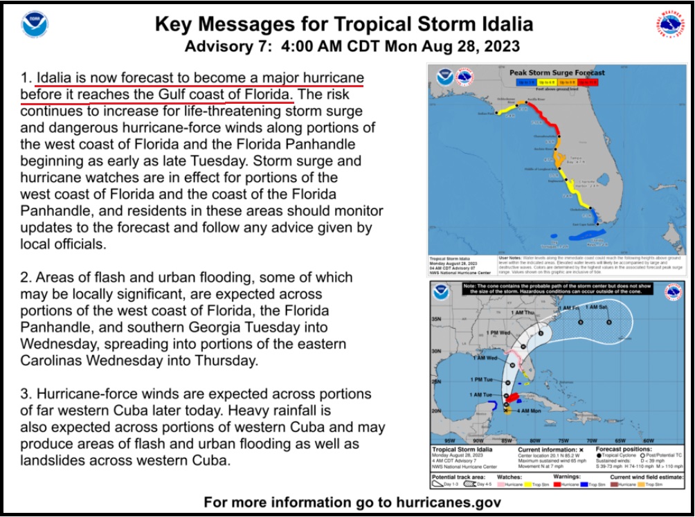
Forecast updates provide a mix of good and bad news. [National Hurricane Center] On the good side, Idalia looks like she will be fast in forward movement as she arrives in Florida. On the bad side of the updates Idalia will be bigger, stronger, and the faster forward movement means the hurricane will be felt further inland potentially into southern Georgia. All advance preparations should be moved to completion within the next 48 hours.
Remember, you are in control. There is no need for panic or dark imaginings. Calm, prudent preparations should be taken if you are in the zone of uncertainty. Specific interests in the Tampa/St Pete region should be playing close attention. A a lot of change in impact zone can happen quickly with these northerly moving storms. Storm surge is expected to be significant.
[National Hurricane Center] – ..”At 700 AM CDT (1200 UTC), the center of Tropical Storm Idalia was located near latitude 20.6 North, longitude 85.2 West. Idalia is moving toward the north near 8 mph (13 km/h). A northward motion is expected through tonight, followed by a faster north-northeast motion on Tuesday and Wednesday. On the forecast track, the center of Idalia is forecast to pass near or over western Cuba tonight, over the extreme southeastern Gulf of Mexico by early Tuesday, and reach the Gulf coast of Florida on Wednesday.
Maximum sustained winds are near 65 mph (100 km/h) with higher gusts. Idalia is forecast to become a hurricane later today and a dangerous major hurricane in the Gulf of Mexico by early Wednesday.”.. (more)
Idalia will come fast, now predicted to make landfall as a category 3+ hurricane. Those in the cone of uncertainty should pay attention, and people in the Tampa and St Pete region who have really lucked out in the past 30 years, should pay very close attention.
I hope you will understand why my proactive tips, advice and planning have modified since our experience with the September 2022 Hurricane, Ian. {Go Deep} Thankfully Idalia is not expected to be anything similar to slow moving Ian. Prior preparation advice remains solid and follows below.
In my last set of proactive suggestions, {GO DEEP HERE} I focused first and foremost on something few discuss, mental capability. Due to what I witnessed in Hurricane Ian with the people of the area, I am always going to put this into the analysis now to provide consideration that few understand. I saw Ian break strong people down and create a PTSD demographic I have never experienced before.
What follows below are things to consider if you are prepping for a hurricane impact and/or deciding whether to stay in your home or evacuate. Standard hurricane preparations should always be followed. Protect your family, secure your property and belongings, and prepare for the aftermath.
This is not a message of alarm. This is a message of prudent action that can assist your consideration, as each person evaluates their situation. What you do before the hurricane hits is going to determine where you are in the recovery phase.
Additionally, and this should be emphasized and discussed within your family, if you cannot be self-sufficient in the aftermath – for any reason, then you should evacuate. Self-sufficiency in this context requires being able to cope for up to several weeks:
(1) potentially without power; (2) potentially without potable running water (3) potentially without internet service; (4) potentially without communication outside the region; and (5) with limited municipal and private sector assistance. If you decide you cannot deal with these outcomes, you should evacuate.
Additionally, as a family or individual, you should also honestly evaluate:
(1) your physical abilities; (2) your emotional and psychological ability to withstand extreme pressures; and (3) your comfort in losing daily routines, familiar schedules and often overlooked things you might take for granted.
Post hurricane recovery is fraught with stress, frustration and unforeseeable challenges. {GO DEEP}
For those in the cone of uncertainty, remember, planning and proactive measures taken now can significantly reduce stress in the days ahead. Plan when to make the best decision on any evacuation (if needed). For now, consider Tuesday night the decision timeframe. As a general rule: take cover from wind – but evacuate away from water.
DAY ONE (Sunday)
Determine Your Risk
Make a Written Plan
Develop and Evacuation Plan
Inventory hurricane/storm supplies.
DAY TWO (Monday)
Get Storm Update
Assemble and Purchase Hurricane Supplies
Contact Insurance Company – Updates
Secure Important Papers.
Strengthen and Secure Your Home √
Make Evacuation plan for your Family.
DAY THREE (Tuesday)
Get Storm Update
Re-Evaluate your Supplies based on storm update.
Finish last minute preparation.
Assist Your Neighbors
If Needed – Tuesday night – Evacuate Your Family
Communication is important. Update your contact list. Stay in touch with family and friends, let them know your plans. Select a single point of contact for communication from you that all others can then contact for updates if needed. Today/tomorrow are good days to organize your important papers, insurance forms, personal papers and place them in one ‘ready-to-go’ location.
Evaluate your personal hurricane and storm supplies; update and replace anything you might have used. Assess, modify and/or update any possible evacuation plans based on your location, and/or any changes to your family status.
Check your shutters and window coverings; test your generator; re-organize and familiarize yourself with all of your supplies and hardware. Check batteries in portable tools; locate tools you might need; walk your property to consider what you may need to do based on the storms path. All decisions are yours. You are in control.
Consider travel plans based on roads and traffic density. Being proactive now helps to keep any future stress level low. You are in control. If you have pets, additional plans may be needed.
One possible proactive measure is to make a list of hotels further inland that you would consider evacuating to. Make that list today and follow updates of the storms’ progress.
Depending on information later today, tomorrow you might call in advance and make a reservation; you can always cancel if not needed. It is better to have a secondary evacuation place established in advance. Being proactive reduces stress. Even if you wait until much later to cancel, it is better to pay a cancellation fee (usually one night charge) than to not have a plan on where to go. Trust me, it’s worth it.
Protect your family. Make the list of possibilities today, make the booking decision in the next 24 hrs.
If you cannot be self-sufficient in the aftermath, leave.
If you choose to stay pay super close attention to the exact path of the storm. A few miles make a massive difference when you are dealing with the possibility of encountering the eyewall of a hurricane.
This is a fury of nature, a battle where the odds are against you, that you may or may not be aware you are contemplating when you are choosing to stay or evacuate. It’s not the hurricane per se’, it’s that much smaller killer buzzsaw – the eyewall- that you are rolling the dice, never to see.
When it comes to the eyewall, the truest measure of the “cone of uncertainty“, the difference between scared out of your mind (victim) and a fight to avoid death (survivor), is literally a matter of a few miles. And there ain’t no changing your mind once it starts.
The worst part of the storm surge will happen immediately to the south of the arriving storm. The onshore winds will push the water. Fortunately, with Idalia, it will likely be only one tidal cycle in duration as the storm is moving quickly.
♦ Hardening your home is a matter of careful thought and physical work. However, every opening into your structure must be protected, leaving yourself with one small exit opportunity just in case. Hopefully you have a bolted door with no glass windows you can use as an emergency exit. If not, select a small window and leave only enough room uncovered for you to get out in case of emergency or structural collapse.
Beyond the ordinary supplies like drinking water, batteries, flashlights, battery or hand-crank radio, generators, gasoline, etc. Evaluate the scale of what you have against the likelihood of weeks without power or water. A few pro tips below:
♦ You can always tell those people who have been through direct hurricane impacts by how they park their cars. If you lose your Florida garage door, you will more than likely lose your roof. [Example Here] That’s just the reality of having a massive opening in your structure to 150 mph winds that will lift the trusses.
If you have two vehicles, put one vehicle inside the garage with the front bumper against the door to help stop the flex (do this carefully). Put the other vehicle outside blocking the garage door facing down the driveway or facing parallel to the garage. The goal is to use the aero dynamics of the car to push the wind away from the door and provide protection.
Purchase a cheap car cover to protect the outside vehicle and/or use old blankets (cable ties, bungee cords) to stop the outside vehicle from getting sandblasted and destroyed. Place double folded corrugated cardboard in front of the radiator to protect it from storm debris. [Example: A five-inch piece of asphalt roof shingle sliced through the grill of my truck during Ian and embedded in the radiator like a razor blade. I found it when the truck overheated.]
Additionally, if you live in a flood zone, or if you are concerned about storm surge, the day before impact take your #1 car to the nearest airport or hotel with a parking garage and park in the upper levels. Take an uber back home if you don’t have a friend or partner to help you. This way you know you will have one workable vehicle, just in case.
♦ Throw all of your patio furniture in the swimming pool if you cannot bring it inside. You can also use your pool water and a bucket to manually flush the toilets after the storm. Also dump extra chlorine into the pool because if your power goes out your pump will not run. The pool will turn into an algae filled mess quickly.
♦ Put three clean and sanitized 30-gallon trash cans in the shower and fill them with water before the storm. This will give you 90 gallons of water for cooking and personal hygiene. You will also need water to manually flush your toilets (if you have a swimming pool, use that water). Bottled water is great for drinking, hydrating and toothbrushing, but you will need much more potable water if the municipal supply is compromised or broken.
♦ A standard 6,500-to-8,500-watt generator will run for approximately 8 hours on five gallons of gasoline. Do not run it all the time. Turn it on, chill the fridge, make coffee, use the microwave or charge stuff, then turn it off. Do this in 4-hour shifts and the fridge will be ok and your gasoline will last longer. Gasoline is a scarce and rare commodity in the aftermath of a hurricane. Gas stations don’t work without power. Check the oil in the generator every few days. Also, have a can of quick start or butane available in case the generator starts acting up.
♦ Extension cords. If you are purchasing them buy at least one 50 to 100′ extension cord with a triple ponytail. This way you can use one cord into a central location to charge up your electronic devices. Establish a central recharging station for phones, pads, laptops, and rechargeable stuff.
♦ Purchase a box of “contractor garbage bags” and just keep them in the garage. These are large, thick, industrial trash bags that fit 40-gallon drums (Home Depot or Lowes). They can be used for trash, or even cut open for tarps in the aftermath of a storm. These thick mil contractor bags have multiple uses following a hurricane.
♦ Do all of your laundry before the hurricane hits. You will likely not have the ability again for a few weeks.
♦ Fill any empty freezer space with bottled water, remove some water to allow for expansion beforehand. You can move those frozen jugs of water into the fridge to help keep temp down after storm, if no power.
♦ Cook a week’s worth of meals in advance of the hurricane. Store in fridge so you can microwave for a meal. Eating a constant diet of sandwiches gets old after the first week. Dinty Moore canned beef stew and or Chef-boy-ardee raviolis can make a nice break…. anything, except another sandwich.
♦ Have bleach for use in disinfecting stuff before and after a hurricane. Also have antibiotics and antiseptics for use. Hygiene and not getting simple infections after a hurricane is critical and often forgotten. Again, this is where the extra potable water becomes important. Simple cuts and scrapes become big deals when clean potable water is not regularly available. Keep your scrapes and abrasions clean and use antiseptic creams immediately.
♦ Do not forget sunscreen and things to relieve muscle aches and pains. Hurricane recovery involves physical effort. You will be sore and/or exposed to the elements. Remember, it’s all about self-sufficiency because the normal services are not available. A well-equipped first aid kit is a must have.
♦ Buy a small camping stove. Nothing big or expensive, just something you can cook on outside in case of emergency. It will be a luxury when you are 2+ weeks without power and all the stores and restaurants are closed for miles.
♦ Those small flashlights that you can strap around your head that take a few AAA batteries? Yup, GOLD. Those types of handsfree flashlights are lifesavers inside and outside when you need to see your way around. Nighttime is especially dark without electricity in the entire town. Doing stuff like filling a generator with gasoline in the middle of the night is much easier with one of those head strap flashlights. Strongly advise getting a few, they’re inexpensive too.
♦ Cash. You will need it. Without power anything you may need to purchase will require cash, especially gasoline. Additionally, anyone you hire to help or support your immediate efforts will need to be paid. Cash is critical. How much, depends on your individual situation, but your cash burn rate will likely go into the thousands in the first few days. Also keep in mind, you may or may not be able to work and without internet access even getting funds into place could be challenging.
♦ Hardware. A box of self-tapping sheet metal screws (short and long) is important, along with a box or two of various wood screws or Tyvex screws. A battery drill or screw gun is another necessity. These are for use in securing stuff now, and in temporary repairs after the damage of the storm has subsided. Check all of this stuff during hurricane prep.
Posted originally on the CTH on August 27, 2023 | Sundance
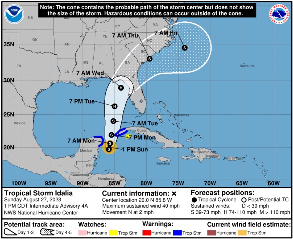
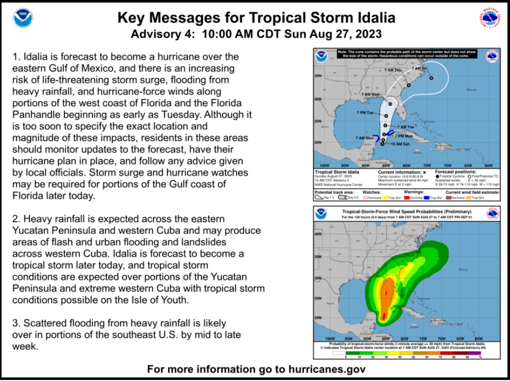
Information from the National Hurricane Center [DATA HERE] indicates currently slow-moving Tropical Storm Idalia will likely speed up quickly tomorrow and form a Hurricane in the Gulf of Mexico on Tuesday. The current cone of uncertainty puts the Northern and Western portion of Florida at greatest risk.
At 100 PM CDT (1800 UTC), the center of Tropical Storm Idalia was located near latitude 20.0 North, longitude 85.8 West. Idalia is moving toward the north near 2 mph (4 km/h), and it is likely to meander near the Yucatan Channel through tonight. A faster motion toward the north is expected on Monday, bringing the system over the eastern Gulf of Mexico.
Maximum sustained winds remain near 40 mph (65 km/h) with higher gusts. Strengthening is forecast, and Idalia is expected to become a hurricane by Tuesday.
Idalia will come fast, most likely making landfall at a category 2 hurricane. Those in the cone of uncertainty should pay attention, and people in the Tampa and St Pete region who have really lucked out in the past 30 years, should pay very close attention.
I hope you will understand why my proactive tips, advice and planning have modified since our experience with the September 2022 Hurricane, Ian. {Go Deep} Thankfully Idalia is not expected to be anything similar to Ian. However, for those in the Tampa/St Pete area, do not be complacent. This is a large metropolitan area with a similar demographic to the impact zone of Ian.
In my last set of proactive suggestions, {GO DEEP HERE} I focused first and foremost on something few discuss, mental capability. Due to what I witnessed in Hurricane Ian with the people of the area, I am always going to put this into the analysis now to provide consideration that few understand. I saw Ian literally break strong people down and create a PTSD demographic I have never experienced before.
What follows below are things to consider if you are prepping for a hurricane impact and/or deciding whether to stay in your home or evacuate. Standard hurricane preparations should always be followed. Protect your family, secure your property and belongings, and prepare for the aftermath.
What you do before the hurricane hits is going to determine where you are in the recovery phase.
Additionally, and this should be emphasized and discussed within your family, if you cannot be self-sufficient in the aftermath – for any reason, then you should evacuate. Self-sufficiency in this context requires being able to cope for up to several weeks:
(1) potentially without power; (2) potentially without potable running water (3) potentially without internet service; (4) potentially without communication outside the region; and (5) with limited municipal and private sector assistance. If you decide you cannot deal with these outcomes, you should evacuate.
Additionally, as a family or individual, you should also honestly evaluate:
(1) your physical abilities; (2) your emotional and psychological ability to withstand extreme pressures; and (3) your comfort in losing daily routines, familiar schedules and often overlooked things you might take for granted.
Post hurricane recovery is fraught with stress, frustration and unforeseeable challenges. {GO DEEP}
For those in the cone of uncertainty, remember, planning and proactive measures taken now can significantly reduce stress in the days ahead. Plan when to make the best decision on any evacuation (if needed). For now, consider Tuesday night the decision timeframe. As a general rule: take cover from wind – but evacuate away from water.
DAY ONE (Today)
Determine Your Risk
Make a Written Plan
Develop and Evacuation Plan
Inventory hurricane/storm supplies.
DAY TWO (Monday)
Get Storm Update
Assemble and Purchase Hurricane Supplies
Contact Insurance Company – Updates
Secure Important Papers.
Strengthen and Secure Your Home
Make Evacuation Decision for your Family.
DAY THREE (Tuesday)
Get Storm Update
Re-Evaluate your Supplies based on storm update.
Finish last minute preparation.
Assist Your Neighbors
If Needed – Evacuate Your Family
Communication is important. Update your contact list. Stay in touch with family and friends, let them know your plans. Select a single point of contact for communication from you that all others can then contact for updates if needed. Today/tomorrow are good days to organize your important papers, insurance forms, personal papers and place them in one ‘ready-to-go’ location.
Evaluate your personal hurricane and storm supplies; update and replace anything you might have used. Assess, modify and/or update any possible evacuation plans based on your location, and/or any changes to your family status.
Check your shutters and window coverings; test your generator; re-organize and familiarize yourself with all of your supplies and hardware. Check batteries in portable tools; locate tools you might need; walk your property to consider what you may need to do based on the storms path. All decisions are yours. You are in control.
Consider travel plans based on roads and traffic density. Being proactive now helps to keep any future stress level low. You are in control. If you have pets, additional plans may be needed.
One possible proactive measure is to make a list of hotels further inland that you would consider evacuating to. Make that list today and follow updates of the storms’ progress.
Depending on information tomorrow you might call in advance and make a reservation; you can always cancel if not needed. It is better to have a secondary evacuation place established in advance. Being proactive reduces stress. Even if you wait until much later to cancel, it is better to pay a cancellation fee (usually one night charge) than to not have a plan on where to go. Trust me, it’s worth it.
Protect your family. Make the list of possibilities today, make the booking decision in the next 24 hrs.
If you cannot be self-sufficient in the aftermath, leave.
If you choose to stay pay super close attention to the exact path of the storm. A few miles make a massive difference when you are dealing with the possibility of encountering the eyewall of a hurricane.
This is a fury of nature, a battle where the odds are against you, that you may or may not be aware you are contemplating when you are choosing to stay or evacuate. It’s not the hurricane per se’, it’s that much smaller killer buzzsaw – the eyewall- that you are rolling the dice, never to see.
When it comes to the eyewall, the truest measure of the “cone of uncertainty“, the difference between scared out of your mind (victim) and a fight to avoid death (survivor), is literally a matter of a few miles. And there ain’t no changing your mind once it starts.
♦ Hardening your home is a matter of careful thought and physical work. However, every opening into your structure must be protected, leaving yourself with one small exit opportunity just in case. Hopefully you have a bolted door with no glass windows you can use as an emergency exit. If not, select a small window and leave only enough room uncovered for you to get out in case of emergency or structural collapse.
Beyond the ordinary supplies like drinking water, batteries, flashlights, battery or hand-crank radio, generators, gasoline, etc. Evaluate the scale of what you have against the likelihood of weeks without power or water. A few pro tips below:
♦ Put three 30-gallon trash cans in the shower and fill them with water before the storm. This will give you 90 gallons of water for cooking and personal hygiene. You will also need water to manually flush your toilets. Bottled water is great for drinking, hydrating and toothbrushing, but you will need much more potable water if the municipal supply is compromised or broken.
♦ A standard 6,500-to-8,500-watt generator will run for approximately 8 hours on five gallons of gasoline. Do not run it all the time. Turn it on, chill the fridge, make coffee, use the microwave or charge stuff, then turn it off. Do this in 4-hour shifts and the fridge will be ok and your gasoline will last longer. Gasoline is a scarce and rare commodity in the aftermath of a hurricane. Gas stations don’t work without power. Check the oil in the generator every few days. Also, have a can of quick start or butane available in case the generator starts acting up.
♦ Extension cords. If you are purchasing them buy at least one 50 to 100′ extension cord with a triple ponytail. This way you can use one cord into a central location to charge up your electronic devices. Establish a central recharging station for phones, pads, laptops, and rechargeable stuff.
♦ Purchase a box of “contractor garbage bags” and just keep them in the garage. These are large, thick, industrial trash bags that fit 40-gallon drums. They can be used for trash, or even cut open for tarps in the aftermath of a storm. These thick mil contractor bags have multiple uses following a hurricane.
♦ Do all of your laundry before the hurricane hits. You will likely not have the ability again for a few weeks.
♦ Cook a week’s worth of meals in advance of the hurricane. Store in fridge so you can microwave for a meal. Eating a constant diet of sandwiches gets old after the first week. Dinty Moore canned beef stew and or Chef-boy-ardee raviolis can make a nice break…. anything, except another sandwich.
♦ Have bleach for use in disinfecting stuff before and after a hurricane. Also have antibiotics and antiseptics for use. Hygiene and not getting simple infections after a hurricane is critical and often forgotten. Again, this is where the extra potable water becomes important. Simple cuts and scrapes become big deals when clean potable water is not regularly available. Keep your scrapes and abrasions clean and use antiseptic creams immediately.
♦ Do not forget sunscreen and things to relieve muscle aches and pains. Hurricane recovery involves physical effort. You will be sore and/or exposed to the elements. Remember, it’s all about self-sufficiency because the normal services are not available. A well-equipped first aid kit is a must have.
♦ Buy a small camping stove. Nothing big or expensive, just something you can cook on outside in case of emergency. It will be a luxury when you are 2+ weeks without power and all the stores and restaurants are closed for miles.
♦ Those small flashlights that you can strap around your head that take a few AAA batteries? Yup, GOLD. Those types of handsfree flashlights are lifesavers inside and outside when you need to see your way around. Nighttime is especially dark without electricity in the entire town. Doing stuff like filling a generator with gasoline in the middle of the night is much easier with one of those head strap flashlights. Strongly advise getting a few, they’re inexpensive too.
♦ Cash. You will need it. Without power anything you may need to purchase will require cash, especially gasoline. Additionally, anyone you hire to help or support your immediate efforts will need to be paid. Cash is critical. How much, depends on your individual situation, but your cash burn rate will likely go into the thousands in the first few days. Also keep in mind, you may or may not be able to work and without internet access even getting funds into place could be challenging.
♦ Hardware. A box of self-tapping sheet metal screws (short and long) is important, along with a box or two of various wood screws or Tyvex screws. A battery drill or screw gun is another necessity. Check all of this stuff during hurricane prep.
Posted originally on the CTH on February 17, 2023 | Sundance
The announcement by President Trump with his intent to visit East Palestine next Wednesday, followed moments later by a reversal announcement from FEMA stating they will now offer support to East Palestine, do not seem coincidental.
The Biden administration, including the EPA, FEMA and Transporation Secretary, was likely very worried about the optics of getting blasted by President Trump very visibly next week for their lack of urgency and concern. Moments after Trump announces his visit, FEMA reverses their prior denial of aid. lol
In a joint statement released Friday night, DeWine and FEMA Regional Administrator Thomas C. Sivak said the agency would deploy a Regional Incident Management Assistance Team (IMAT) to Columbiana County starting Saturday, along with a senior response official. The workers will “support ongoing operations, including incident coordination and ongoing assessments of potential long-term recovery needs.”
[…] DeWine had previously requested federal help, and today the Department of Health and Human Services announced toxicologists from the Centers for Disease Control and Prevention would be journeying to East Palestine to assist with public health testing. However, the governor’s request for FEMA assistance was initially denied, with the agency apparently telling his office the current situation “[did] not quality for assistance.” (read more)
Posted originally on the conservative tree house on November 9, 2022 | Sundance
Hurricane conditions are expected from Boca Raton to Flagler/Volusia County line along the coast in Florida tonight. However, do not focus only on the center of the storm. Hurricane winds extend 25 miles from center, tropical storm winds 400+ miles from center, and massive rain are anticipated over central Florida with significant flooding north of Lake O. Residents along coastal and inland waterways should be fully prepared for this storm. Overnight conditions will deteriorate rapidly.
At 1000 PM EST (0300 UTC), the center of Hurricane Nicole was located near latitude 27.0 North, longitude 78.9 West. Nicole is moving toward the west-northwest near 13 mph (20 km/h). A turn toward the northwest is expected on Thursday, followed by a turn toward the north and north-northeast on Friday.
On the forecast track, the center of Nicole will move onshore the east coast of Florida within the hurricane warning area late tonight or early Thursday. Nicole’s center is then expected to move across central and northern Florida into southern Georgia Thursday and Thursday night, and into the Carolinas Friday.
Maximum sustained winds are near 75 mph (120 km/h) with higher gusts. Little change in strength is expected until Nicole makes landfall along the Florida east coast. Nicole is expected to weaken while moving across Florida and the southeastern United States Thursday through Friday, and it is likely to become a post-tropical cyclone by Friday afternoon. (more)
Many of us have spent the past 36 hrs preparing for this storm; however, my gut is telling me many are not ready for the potential flooding from Nicole. Toolboxes and supplies are loaded, and relief/recovery supplies staged south of Lake-O are prepared to move north as needed.
Now, is when the southeast and southcentral east coast needs to hunker down in safe, secure and hardened structures away from the water.
Power is likely to be lost along the coastal and near coastal areas of Florida as well as central Florida north of Lake-O. Stay inside during the storm passing and pay attention to local officials for instructions related to road closures and transit corridors.
East coast of Florida Treepers, if you find yourself in an emergency situation, feel free to reach out in the comment section or email directly.
Keep a good thought, all will be okay.
I know it is unnerving when these storms move in at night, but everything will be okay. Nicole will hopefully pass through quickly, but the rain, ground saturation and potential for flooding may be problematic for several days.
Hurricanes can be frightening; downright scary. There’s nothing quite like going through a few to reset your outlook on just how Mother Nature can deliver a cleansing cycle to an entire geographic region. The sounds are scary. Try to stay calm despite the nervousness. Trees will bend and break; the sounds are dramatic.
If you are near the eyewall, there’s a specific sound when you are inside a hurricane that you can never forget. It ain’t a howl, it’s a roar. It is very unique sound in depth and weight. Yes, within a hurricane wind has weight. Stay clear of windows and doors, and within an interior room of the house or apartment if possible.
That scary roar sounds like it won’t ever quit…. it will… eventually; but at the time you are hunkering down, it doesn’t seem like it will ever end.
A hurricane wind, even a moderate one, is a constant and pure rage of wind that doesn’t ebb and flow like normal wind and storms. Hurricane wind is heavy, it starts, builds and stays; sometimes for hours. Relentless, it just won’t let up. And then, depending on Nicole’s irrelevant opinion toward your insignificant presence, it will stop.
Judging by the forward speed the hurricane force winds will likely last around 2 hours before she lets up.
Meanwhile, tomorrow you might walk outside and find yourself a stranger in your messed up neighborhood. It will all be cattywampus. Trees gone, signs gone, crap everywhere, if you don’t need to travel, DON’T.
I mean CRAP e.v.e.r.y.w.h.e.r.e. Stay away from powerlines.
Try to stay within your immediate neighborhood for the first 36-48 hours. Keep the roadways and main arteries clear for recovery workers, power companies and relief trucks.
Remember, when it is safe to drive, if the power is out – every single intersection must be treated like a four-way stop…. and YOU ARE GOING TO HAVE TO PAY ATTENTION. Even the major intersections.
You’ll need to override your brain tendency to use memory in transit. You’ll need to pay close attention and watch for those who ain’t paying close attention. Travel sparingly, it’s just safer.
Remember, this is important – YOU are the first responder for your neighborhood. Don’t quit. Recovery is a process. Depending on the scale of the impact zone, the process can take days or weeks. Take care of your family first; then friends and neighborhood, and generally make a conscious decision to be a part of any needed solution.
Keep a good thought. Who knows, we might even end up shaking hands.
It might suck a little bit, but it will be okay. Promise.
Posted originally on the conservative tree house on October 29, 2022 | Sundance
The ‘context’ of Ian was shared previously {Go Deep}. Here we outline things to consider if you are prepping for a hurricane impact and/or deciding whether to stay in your home or evacuate. Standard hurricane preparations should always be followed. Protect your family, secure your property and belongings, and prepare for the aftermath.
What you do before the hurricane hits is going to determine where you are in the recovery phase.
Additionally, and this should be emphasized and discussed within your family, if you cannot be self-sufficient in the aftermath – for any reason, then you should evacuate.
Self-sufficiency in this context requires being able to cope for up to several weeks:
(1) potentially without power; (2) potentially without potable running water (3) potentially without internet service; (4) potentially without communication outside the region; and (5) with limited municipal and private sector assistance. If you decide you cannot deal with these outcomes, you should evacuate.
Additionally, as a family or individual, you should also honestly evaluate:
(1) your physical abilities; (2) your emotional and psychological ability to withstand extreme pressures; and (3) your comfort in losing daily routines, familiar schedules and often overlooked things you might take for granted. Post hurricane recovery is fraught with stress, frustration and unforeseeable challenges.
I saw a video presented by a structural engineer who was sharing his experience with Hurricane Ian. I am going to use his video for a few references because even with professional credentials, some of the common mistakes people make are highlighted in his experience. Keep in mind his video is taken about 30 miles inland from where the majority impact area (coastal region) is located.
The video below was shot from the soft side (western side) of the storm, and if we were to scale the difference between his experience and a person who was located in/around Fort Myers Beach, Sanibel, Pine Island or Cape Coral, he would be around a “5” on a ten-point impact scale.
Meaning the severity of conditions 30 miles southeast of him was twice as severe as his inland experience.
Key Points – At the 21: 35 moment (prompted), notice how his #2 vehicle is parked outside. Also, at the 22:00 minute moment, notice what he is describing and showing with his garage door and how his #1 vehicle (a pickup truck) is positioned inside the garage. WATCH:
.
♦ This is exactly what I was talking about in hurricane preparation when discussing the garage door. If that videographer was located 30 miles southeast, and/or his house was positioned facing West, instead of North, his garage door would have failed. If you lose the garage door, YOU COULD LOSE YOUR ROOF.
You can always tell those people who have been through direct hurricane impacts by how they parked their cars. I have never included this in the hurricane advice before so it’s worth a mention. If you lose your Florida garage door you will more than likely lose your roof. That’s just the reality of having a massive opening in your structure to 150 mph winds that will lift the trusses.
If you have two vehicles, put one vehicle inside the garage with the front bumper against the door to help stop the flex (do this carefully). Put the other vehicle outside blocking the garage door facing down the driveway or facing parallel to the garage. The goal is to use the aero dynamics of the car to push the wind away from the door and provide protection.
Purchase a cheap car cover to protect the outside vehicle and/or use old blankets (cable ties, bungee cords) to stop the outside vehicle from getting sandblasted and destroyed. Place double folded corrugated cardboard in front of the radiator to protect it from storm debris.
Additionally, if you live in a flood zone, or if you are concerned about storm surge, the day before impact take your #1 car to the nearest airport or hotel with a parking garage and park in the upper levels. Take an uber back home if you don’t have a friend or partner to help you. This way you know you will have one workable vehicle, just in case.
♦ Another lesson from Ian, if you drive an electric vehicle and sustain saltwater intrusion (of any level) your car is not safe. Saltwater makes the vehicle batteries extremely dangerous, and they could spark or catch fire. Multiple homes survived Hurricane Ian only to have the electric car catch fire in the garage and burn the house to the ground. Hurricane rain is saltwater rain. The fire department was begging people to put their ev’s outside and not to plug them in. Dozens of ev’s also erupted in flames while driving down the streets after the storm.
Back to the video above…
♦ Notice at 24:30 of the video this professional structural engineer is standing and physically supporting his glass patio doors, with his wife, trying to keep them from breaking in due to wind and pressure changes. DO NOT DO THIS ! That is beyond dangerous. Any small item of debris (even a small twig or branch) could hit that window and shatter it, turning flying glass into instant flying blades.
Put 3/4-inch plywood or steel bolted hurricane shutters over all your windows and doors. Period. This is not an option. My steel bolted hurricane shutters were hit with debris so hard – whatever it was physically dented the steel. Every window and door need to be covered and protected, especially glass patio doors (even if tempered). Do not think you can stand there and protect glass doors. It’s beyond dangerous.
♦ Hardening your home is a matter of careful thought and physical work. However, every opening into your structure must be protected, leaving yourself with one small exit opportunity just in case. Hopefully you have a bolted door with no glass windows you can use as an emergency exit. If not, select a small window and leave only enough room uncovered for you to get out in case of emergency or structural collapse.
Beyond the ordinary supplies like drinking water, batteries, flashlights, battery or hand-crank radio, generators, gasoline, etc. Evaluate the scale of what you have against the likelihood of weeks without power or water. A few pro tips below:
♦ Put three 30-gallon trash cans in the shower and fill them with water before the storm. This will give you 90 gallons of water for cooking and personal hygiene. You will also need water to manually flush your toilets. Bottled water is great for drinking, hydrating and toothbrushing, but you will need much more potable water if the municipal supply is compromised or broken.
♦ A standard 6,500-to-8,500-watt generator will run for approximately 8 hours on five gallons of gasoline. Do not run it all the time. Turn it on, chill the fridge, make coffee, use the microwave or charge stuff, then turn it off. Do this in 4-hour shifts and the fridge will be ok and your gasoline will last longer. Gasoline is a scarce and rare commodity in the aftermath of a hurricane. Gas stations don’t work without power. Check the oil in the generator every few days. Also, have a can of quick start or butane available in case the generator starts acting up.
♦ Extension cords. If you are purchasing them buy at least one 100 to 150′ extension cord with a triple ponytail. This way you can use one cord into a central location to charge up your electronic devices. Establish a central recharging station for phones, pads, laptops, and rechargeable stuff.
♦ Purchase a box of “contractor garbage bags” and just keep them in the garage. These are large, thick, industrial trash bags that fit 40-gallon drums. They can be used for trash, or even cut open for tarps in the aftermath of a storm. These thick mil contractor bags have multiple uses following a hurricane.
♦ Do all of your laundry before the hurricane hits. You will likely not have the ability again for a few weeks.
♦ Cook a week’s worth of meals in advance of the hurricane. Store in fridge so you can microwave for a meal. Eating a constant diet of sandwiches gets old after the first week. Dinty Moore canned beef stew and or Chef-boy-ardee raviolis can make a nice break…. anything, except another sandwich.
♦ Have bleach for use in disinfecting stuff before and after a hurricane. Also have antibiotics and antiseptics for use. Hygiene and not getting simple infections after a hurricane is critical and often forgotten. Again, this is where the extra potable water becomes important. Simple cuts and scrapes become big deals when clean potable water is not regularly available. Keep your scrapes and abrasions clean and use antiseptic creams immediately.
♦ Do not forget sunscreen and things to relieve muscle aches and pains. Hurricane recovery involves physical effort. You will be sore and/or exposed to the elements. Remember, it’s all about self-sufficiency because the normal services are not available. A well-equipped first aid kit is a must have.
♦ Buy a small camping stove. Nothing big or expensive, just something you can cook on outside in case of emergency. It will be a luxury when you are 2+ weeks without power and all the stores and restaurants are closed for miles.
♦ Those small flashlights that you can strap around your head that take a few AAA batteries? Yup, GOLD. Those types of handsfree flashlights are lifesavers inside and outside when you need to see your way around. Nighttime is especially dark without electricity in the entire town. Doing stuff like filling a generator with gasoline in the middle of the night is much easier with one of those head strap flashlights. Strongly advise getting a few, they’re inexpensive too.
♦ Cash. You will need it. Without power anything you may need to purchase will require cash, especially gasoline. Additionally, anyone you hire to help or support your immediate efforts will need to be paid. Cash is critical. How much, depends on your individual situation, but your cash burn rate will likely go into the thousands in the first few days. Also keep in mind, you may or may not be able to work and without internet access even getting funds into place could be challenging.
♦ Hardware. A box of self-tapping sheet metal screws (short and long) is important, along with a box or two of various wood screws or Tyvex screws. A battery drill or screw gun is another necessity. Check all of this stuff during hurricane prep.
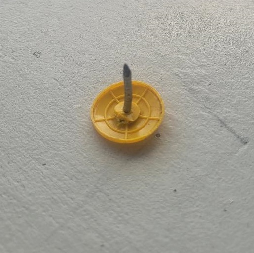
♦ ADD. I forget my #1 personal nemesis in the aftermath (pictured below):
Roofing nails. The pesky roofing nails. Thousands of em’, all over. Those buggers are everywhere, and they will go through a flip-flop, sneaker sole or car tire perfectly. Most of them are black (not yellow) like the ones above. Some of them have square of flat tops to help them stand up just perfect to find your tires.
I happen to believe roofing nails are actually tire magnets with some sort of automatic triggering system to jump in front of your car at the worst possible moments. On the positive side, I think my neighborhood is safe because my tires have picked up every one of em’. LOL and Grrrr…
More later…. but I hope this is useful. [Lie to me, even if it ain’t. lol.]
Posted originally on the conservative tree house on October 29, 2022 | Sundance
Many CTH readers know I have been involved in hurricane prep and recovery as a longtime member of a civilian emergency response team. I have physically been through four direct hurricane impacts and responded to recovery efforts in more than fifteen locations, often staying for days or weeks after the initial event.
Through the years I have advised readers on best practices for events before, during and after the storm. In this outline my goal is to take the experience from Hurricane Ian and overlay what worked and what doesn’t work from a perspective of the worst-case scenario.
Hurricane Ian was a worst-case scenario.
Let me be clear from the outset, I am not advising anyone to put greater weight on my opinion or ignore local emergency officials or professionals in/around the disaster areas. What I am going to provide below is my own experience after decades of this stuff, against the backdrop of Ian, and just provide information that you may wish to consider if you are ever faced with a similar situation.
Hurricane preparation can be overlaid against other types of disaster preparation, there are some commonalities. However, for the sake of those who live on/around the U.S. coastal areas where hurricanes have traditionally made impact, the specifics of preparation for this type of storm are more pertinent. I’m going to skip over the basic hurricane preparation and get into more obscure and granular details, actual stuff that matters, that many may not be familiar with.
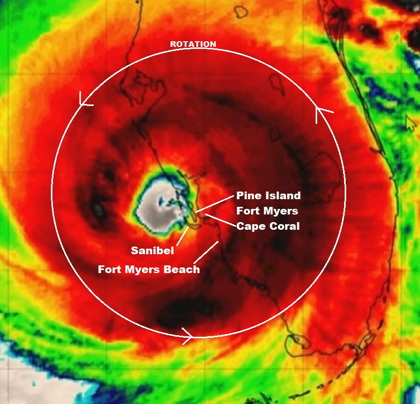
Let me start by sharing a graphic that you may overlay with the information you may have already seen from national media coverage. The graphic below shows Hurricane Ian in relation to Southwest Florida and points to locations that you may have seen on the news. The context of understanding Ian is going to be critical when contemplating preparation, so it must be emphasized.
This satellite image was likely taken around 4 to 7 pm on the evening of September 28, 2022, approximately three hours after Hurricane Ian officially made landfall at Bokeelia, a small community on the Northern end of Pine Island. All of my discussion below is from the ‘major impact zone’.
The satellite image above was taken during daylight after five or six hours of hurricane force winds (150+ mph) had already been impacting the SWFL coast.
For the areas of greatest impact, the event began roughly around 1:00pm and lasted until around 9:00pm. Ignore the red and dark area (rainfall) and instead focus on the green/blue ring around the eye, that is the “eye wall”, or what we call the “buzzsaw“.
From the perspective of the Fort Myers Beach, Cape Coral, Pine Island and Sanibel area, the first round of severe winds came from East to West around lunchtime on 9/28.
By 2pm the entire SWFL coastal region was without power. The easterly wind lasted about 2 hours, then as hurricane Ian meandered off the coast (retaining fuel) in a generally north-northeast direction, the winds shifted coming from the South. This is when the buzzsaw really started destroying buildings and infrastructure.
Ian was only moving in a forward direction around 5 to 8mph. That 150 mph buzzsaw (eyewall) is about 40 miles wide. Only half of the buzzsaw (the eastern side) was over land. The western side was providing hot water fuel the entire time. That buzzsaw was over the SWFL coastline for more than 8 hours.
Sanibel Lighthouse, Before and After
At approximately 5pm the most severe part of the storm surge started coming into the SWFL coast as the South and West winds began pushing massive amounts of water from the Gulf of Mexico onto the coast.
You have likely seen video from Fort Myers Beach as these moments were happening. The storm surge continued growing in scale for several hours. Combined with the wind, this storm surge is what erased most of the structures on Fort Myers Beach, Sanibel, Captiva, Upper Captiva Island, Saint James City, Pine Island, Matlacha and Bokeelia.
The 5 to 9pm timeframe is also when most of the flooding and storm surge damage took place in South Fort Myers and Cape Coral. Even after the buzzsaw cleared the area (9pm), the winds from the West at the bottom of the storm kept the water level high.
The water exit (back into the Gulf of Mexico) did not begin until the tidal shift after midnight. Due to the slow movement of the storm the total time of the storm surge impact was a jaw-dropping 8 to 10 hours. Many people drowned.
The old axiom remained mostly true, “hunker down from wind, but run from water.”
Now, I say “mostly true“, because to be brutally honest -due to the unique nature of Ian- if you are going to be inside that killer buzzsaw for 8 hours, hunkering down is really not a safe option. Fortunately, Ian was a rare system in terms of its slow-moving nature, even after hitting land. Most hurricane impact events are less than 3 hours in duration. Ian was dangerously unique.
To give scale to the size of the buzzsaw, again we are talking about the most dangerous part of any hurricane – the eyewall itself, this next image shows a comparison between the eyewall of Hurricane Charley in 2004 and the eyewall of Hurricane Ian in 2022.
That is the eye of Charley overlaid inside the eye of Ian in almost the same location. You can see how much bigger the buzzsaw was for Ian as opposed to Charley.
Both Hurricane Charley (’04) and Hurricane Ian (’22) came ashore in generally the same place. Charley made official landfall at Upper Captiva Island and Ian at Bokeelia. The distance between both landfall locations is only about 4 miles apart as the crow flies.
Both storms were Cat-4 landfall events. However, Charley was much smaller, had a smaller buzzsaw and moved quickly around 20 mph. Ian was big, had a much bigger buzzsaw and moved slowly around 5pmh.
The duration of Charley was around 2 to 3 hrs. The duration of Ian was around 8 to 9 hrs. Ian was bigger and just moved slower. Inside this distinction you discover why, despite their almost identical regional proximity, the damage from Ian was much more severe. Topography was changed.
I am focusing a lot of time on this similarity aspect because you cannot take a previous storm reference as a context for your ability to survive the next storm. They are all different, even when they hit the same place.
While more SWFL people evacuated for Hurricane Ian, and that is a profoundly good thing, the memory of getting through Hurricane Charley likely made many people think they could just prep, hunker down and get through it. The “I got this” reference of surviving through Charley may have led to people dying, because Ian wasn’t Charley…. not even close.
Having said that, I personally over prepare for these events. This time it was critical.
You have likely seen video from the hurricane area during the event. You have likely seen video from areas in/around the impact zone.
However, let me tell you something you have not seen…..
…. you have not seen any video of what was happening inside that eyewall. You have not seen any video of the buzzsaw at work.
Why? Because anyone who would attempt to step outside a structure into that buzzsaw would not survive. Any CCTV equipment, camera or video recording attached to a structure inside that coastal buzzsaw was almost certainly destroyed.
A physical human body does not step into 150 MPH winds and return.
This is a fury of nature, a battle where the odds are against you, that you may or may not be aware you are contemplating when you are choosing to stay or evacuate. It’s not the hurricane per se’, it’s that much smaller killer buzzsaw – the eyewall- that you are rolling the dice, never to see.
When it comes to the eyewall, the truest measure of the “cone of uncertainty“, the difference between scared out of your mind and almost certain death, is literally a matter of a few miles,…. and there ain’t no changing your mind once it starts.
I have created this site to help people have fun in the kitchen. I write about enjoying life both in and out of my kitchen. Life is short! Make the most of it and enjoy!
This is a library of News Events not reported by the Main Stream Media documenting & connecting the dots on How the Obama Marxist Liberal agenda is destroying America