Posted originally on the conservative tree house on June 27, 2021 | Sundance | 97 Comments
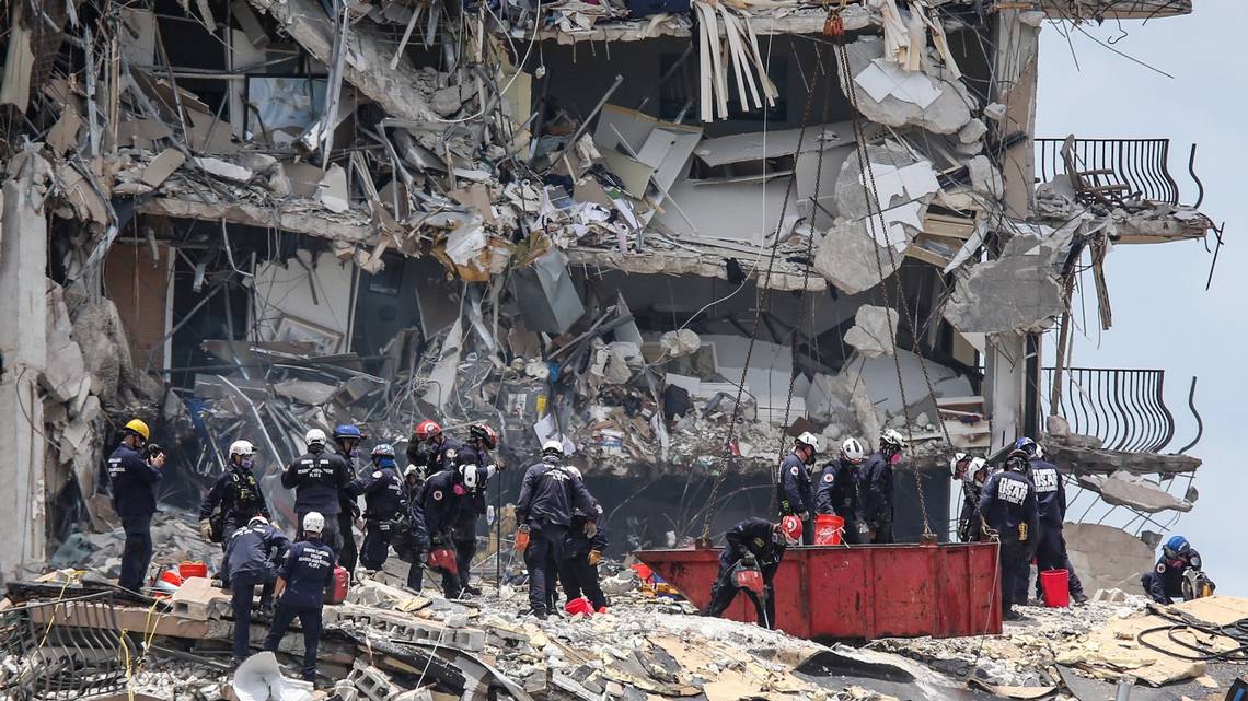
The tragic mission is still called “search and rescue” as more heavy equipment is brought in on the fourth day of rescue efforts. In the past day four more bodies “and additional human remains” have been recovered from the ruble of the collapsed 12 story condo building in Surfside Florida.
Hopes are diminishing for the 156 people still missing. Specific prayers this Sunday for the families of those lost and for the safety of the rescue workers who are in very perilous surroundings.
Miami Dade – Rescuers have recovered another four bodies in the wreckage of the Champlain Towers South condominium collapse, bringing the total to nine dead and 156 still missing since the Surfside building collapsed early Thursday.
The latest victims were discovered along with “additional human remains” in a 135-foot long trench dug into the rubble to add rescue and recover teams — the newest tactic in the round-the-clock excavation of an unstable, sometimes shifting mountain of debris.
“We are making every effort to identify those others that have been recovered,” Miami-Dade Mayor Daniella Levine Cava said in a Sunday morning press conference. (read more)
Posted originally on the conservative tree house on June 25, 2021 | Sundance | 68 Comments
Heartbreak north of Miami-Dade as the number of missing persons in the Surfside condo collapse rises to 159 people. Search and rescue efforts continued throughout the night and morning as rescue workers enter their 36th hour of operations. The work is dangerous as the remaining elements of the building are very unstable.
MIAMI-DADE The arduous and heartbreaking task of recovering the bodies of victims at the site of the collapse of the Champlain Towers South condo in Surfside began overnight and continued into a somber Friday morning in an unfolding tragedy that is feared to be the worst building failure in Florida history.
Miami-Dade Mayor Daniella Levine Cava said Friday morning that the number of people who are unaccounted for in Thursday’s building collapse increased to 159 — dramatically higher than the 99 reported earlier. The official death toll rose to four, as three more people were found in the rubble.
She said 120 people are now accounted for but stressed that all the numbers are “fluid” because some residents may not have been in the building when it collapsed.
[…] While the cause of the 12-story oceanfront condo tower’s collapse remains unknown, Levine Cava and other county officials confirmed that there was no sinkhole under the building.
State Chief Financial Officer Jimmy Patronis, who also serves as the state fire marshal, said on CNN early Friday morning the rescue mission would continue into the day, with search-and-rescue teams from Naples and Orlando coming to relieve Miami-Dade searchers who had been working their way through the rubble for more than 24 hours. (read more)
While the cause of the collapse is unknown the fact the building was located near the coast in South Florida; was built with an underground parking garage, and previous reports of the building slowly shifting/sinking point to structural instability and potential design flaws from the 40 year-old construction. Not to be too blunt, but put a barstool on a beach and sit on it…. that’s the stability element many structural engineers in S-FL are discussing.
Regardless of cause this is a horrific event and our thoughts and prayers go out to the victims and their families. The rescue workers are also facing peril as the elements of the remaining building that did not collapse are tenuous at best. We pray for the safety of those trying around the clock to rescue and recover the lost.
Posted originally on the conservative tree house on June 24, 2021 | Sundance | 306 Comments
Reunification Hotline 305-614-1819
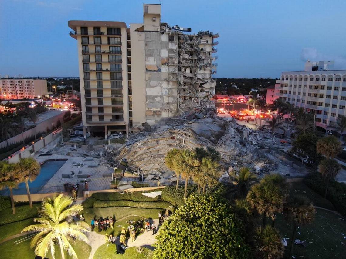
Champlain Towers is a 12 story condominium building located in the small, beachside town of Surfside, Florida, about six miles north of Miami Beach. Miami-Dade County police said 53 residents have been identified and located safely; however, as many as 99 people are reported missing. There were about 55 units in the tower that collapsed.
The collapse happened at approximately 1:30am this morning.
The building is 40-years old and is located in an area very familiar to CTH. This is an affluent community with many Jewish residents. Our thoughts and prayers are with the missing and their families. CCTV from a neighboring complex shows the center of the tower gave way first, with the rest of the structure collapsing into a pile of rubble. The cause of the collapse is unknown.
Surfside Commissioner Eliana Salzhauer said “the building was undergoing a required 40-year recertification to ensure its structural integrity, and that the building’s roof was being redone. She added that residents told her a building inspector had visited Champlain Towers on Wednesday, but she did not know what the inspector found. It is unknown if any construction activity contributed to the disaster.” (Miami Herald Article Link)
Florida Governor Ron DeSantis arrived on scene this afternoon and gave a press conference:
This is a horrific collapse. The scale of this is almost unfathomable.
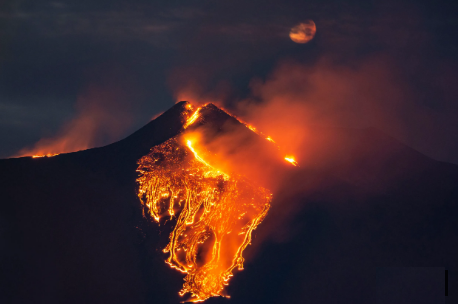
The lava flows from the Mt. Etna volcano, near Catania in Sicily, Italy, Feb. 23, 2021, are providing spectacular images. The explosion, which began just before midnight on Monday night, sent a plume of ash that rose for several kilometers from the top of Etna, as reported by The National Institute of Geophysics and Volcanology, Etneo Observatory.
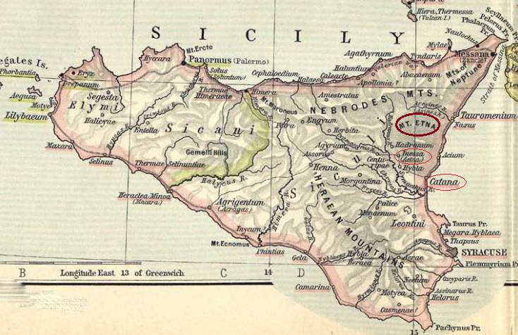
The earliest historical writer to mention an eruption of Mount Etna is Thucydides. In the course of his history of the Peloponnesian War, he records that there had been three eruptions of the volcano since the Greeks had settled in Sicily. He says the first occurred in the spring of 425BC when “a fire-flood issued from Aetna as on former occasions and destroyed the territory of Catania”; the preceding one took place fifty years before, which is doubtless the one described by Pindar and Aeschylus and mentioned in the “Marmor Parium”15 as happening in 479BC. He makes no mention of the date of the third one. These are the earliest historical records of the volcano, which therefore do not antedate the fifth century BC. After 400BC several eruptions are recorded in Graeco-Roman writers. Of these, the chief ones are the following: 396 BC, when a great lava stream reached the sea on the northeastern base of the volcano in which Catania was destroyed. Interestingly, perhaps just before Julius Caesar (100-44BC) crossed the Rubicon in 49BC, Vergil mentions as one of the signs of the gods’ displeasure at Caesar’s untimely death was an eruption of Mt Aetna.
Following the destruction of Catana by Mt Etna, the refugees fled to Inessa, a small suburb. They renamed that city Aitna and began to strike coinage in the name of their new city.
Hurricane Delta posed a particularly dangerous threat to Louisiana as much of the exact same area was previously hit by Hurricane Laura just six weeks ago. With massive amounts of debris from Laura still in the cleanup process Hurricane Delta was poised to deliver a troubling double-whammy. However, that said, first responders and state officials are saying there were no fatalities from Delta – Prayers Answered.
[Via ABC] Hurricane Delta, now a tropical depression, made landfall near Creole, Louisiana, on Friday evening, with nearly 11 million people in the storm’s path. More than 600,000 power outages were reported across Texas, Louisiana and Mississippi early Saturday afternoon as the storm’s remnants moved further inland.
Delta is now expected to move across western and northern Mississippi before heading into the Tennessee Valley tonight and Sunday. (more)
Material stuff can be replaced, people cannot. Now the incredible heroes from across the United States will move in to begin restoring power. Massive numbers of power crews are working to rebuild the grid; tens of thousands of tons of debris being removed. [Much of what is now called “debris” represents the cherished belongings of thousands of lives.]
Now it’s time to try and restore some sense of normalcy for those who have been impacted, and commit to a long-term rebuilding process. Stay strong. Thousands have staged. Help is on the way…
“It was quite a night,” Lake Charles resident Don Dixon said as he cleaned up branches and assessed his home in the Louisiana city. Dixon worried as the rain poured and the wind howled, but the damage was not as bad as he had feared.
“All in all, we got punched in the face, but we’re getting back up,” Dixon said.
Anther resident, Caleb Cormier, drove around all morning, and said most of the damage he’d seen was debris on the roads and one downed electrical line.
“It really is nowhere near the amount of damage that Hurricane Laura did, and I’m very grateful for that,” Cormier said as he cleared up tree branches and garbage from the street so it wouldn’t be a hazard for passing cars.
Still, damage reached far inland, with trees shorn of leaves and falling onto streets in Louisiana’s capital of Baton Rouge. Widespread power outages were also reported. LINK
A glorious melding of dirty fingernails all arriving for the recovery meet-up. Depending on your proximity to the bigger picture objectives at hand, you will cherish their arrival.
Recovery teams will begin a street-by-street review; everything needs to be evaluated prior to thinking about beginning to rebuild a grid. Your patience within this process is needed; heck, it ain’t like you’ve got a choice in the matter…. so just stay positive.
Meanwhile, you might walk outside and find yourself a stranger in your neighborhood.
It will all be cattywampus.
Trees gone, signs gone, crap everywhere, if you don’t need to travel, DON’T.
I mean CRAP e.v.e.r.y.w.h.e.r.e.
Stay away from power-lines.
Try to stay within your immediate neighborhood for the first 36-48 hours. Keep the roadways and main arteries clear for recovery workers, power companies and fuel trucks.
Remember, when it is safe to drive, every single intersection must be treated like a four-way stop…. and YOU ARE GOING TO HAVE TO PAY ATTENTION. Even the major intersections.
You’ll need to override your brain tendency to use memory in transit. You’ll need to pay close attention and watch for those who ain’t paying close attention. Travel sparingly, it’s just safer.
Stage one recovery focuses on major arteries… then secondary… then neighborhood etc. It’s a process. Oh, and don’t get mad if your fancy mailbox is ploughed-over by a focused front end loader who is on a priority mission to clear a path. Just deal with it. Those same front-end loaders will also be removing feet of sand from coastal roads. Don’t go sightseeing… stay in your neighborhood.
For the first 36-48 hours, please try to stay close to home, in your neighborhood. Another reason to stay close to home is the sketchy people who can sometimes surface, looters etc. Staying close to home and having contact with your neighbors is just reasonable and safer.
Phase-1 recovery is necessarily, well, scruffy…. we’re just moving and managing the mess; not trying to clean it up yet. It’ll be ok. There are going to be roofing nails everywhere, and you will likely get multiple flat tires in the weeks after the hurricane.
If you are on the road and there’s a convoy of utility trucks on the road, pull over. Treat power trucks and tanker trucks like ambulances and emergency vehicles. Pull over, give them a clear road and let them pass.
When everyone gets to work, if you see a line-man, pole-digger or crew say thanks. Just simple “thanks”. Wave at them and give them a thumbs-up. No need to get unnecessarily familiar, a simple: “thank you for your help” will suffice. You know, ordinary people skills.
Many of these smaller crews will be sleeping in cots, or in their trucks while they are working never-ending shifts. Some will be staging at evacuation shelters, likely schools and such. Once you eventually start getting power back, if you see a crew in a restaurant, same thing applies… “thanks guys”.
Same goes for the tanker truckers. The convenience stores with gas pumps are part of the priority network. Those will get power before other locales without power. Fuel outlets are a priority. Fuel is the lifeblood of recovery. Hospitals, first responders, emergency facilities, fuel outlets, then comes commercial and residential.
Pray together and be strong together. It might sound goofy to some, but don’t be bashful about being openly thankful in prayer.
It will be ok.
It might be a massive pain in the a**, but in the end, it’ll be ok.
The U.S. Geological Survey said the quake’s magnitude was 7.7, while Mexico’s seismological institute put its strength at 7.1. Quakes of such size can be devastating. Historically, when strong earthquakes hit this region, we tend to see smaller quakes hit in the New York City area. Meanwhile, the Indonesia volcano Mount Merapi’s is also starting to erupt and that has been the area where the volcanic activity has been large enough in history to create volcanic winters. In Europe, crops are already behind season in many areas because of a very cold May/June.
Many people have been writing in asking what does Socrates have to say on the earthquake that shook Puerto Rico. This was the first people have really felt since 1917. While such earthquakes may appear to be rare events, there is a general 19.29-year cycle on earthquakes in that general region of the Caribbean. Here is the data of just major earthquakes in the Caribbean.
Year
Location
Magnitude
1692
Jamaica
7.5
1751
Port-au-Prince
8
59
1770
Port-au-Prince
7.5
19
1787
Boricua
8
17
1842
Cap-Haïtien
8.1
55
1843
Guadeloupe
8.5
1
1907
Kingston
6.5
64
1918
San Fermín
7.1
11
1946
Dominican Republic
8.1
28
1974
Lesser Antilles
6.9
28
1984
San Pedro Basin
6.7
10
2003
Dominican Republic
6.4
19
2004
Les Saintes
6.3
1
2007
Martinique
7.4
3
2010
Haiti
7
3
2018
Haiti
5.9
8
2020
Puerto Rico Basin
6.5
2
There is a general cycle of 19.29 years which was due 2019.71. This is a cycle based on the entire region and it reflects an average, not a specific location. Nonetheless, we should see a noticeable increase in earthquake events in the region.
What you will notice is that the last column on the right which is the number of years between events. Note that since the 2004 event, the frequency has changed. This is what I have been warning about which ties into the fraud being carried out about Climate Change groups of Greenpeace and Al Gore.
There was a solar maximum in 2000. In 2006 NASA initially expected a solar maximum in 2010 or 2011, and thought that it could be the strongest since 1958. However, the solar maximum was not declared to have occurred until 2014, and even then was ranked among the weakest on record.
Even since the peak in 2000, the profile of volcanoes and earthquakes on a global scale have increased. This is what takes place during solar minimum phases because the energy waves coming from the sun change. It is believed that the types of waves emitted from the sun penetrate the earth and may be causing greater activity in volcanoes and earthquakes. This correlates also with the ECM during the historical rise and fall of civilizations.
This is all a backdrop to what Socrates is warning about a return of inflation and global cooling due to solar minimum which will result in also food shortages. So the climate change conspiracy groups may get their wish – reduction in population, but from global cooling
Steve Harrigan reports from Abaco Island in the Bahamas as search and rescue efforts continue. The scale of the devastation is incredible; everything is gone, and worse yet the topography has changed removing the ability of deep water ports to be used in/around most of the northern Bahama islands. The anticipated death toll is expected to be dramatic. [Disturbing Content]
.
The duration of Hurricane Dorian has changed the underwater topography making access to the Island communities even more difficult, if not impossible. The Bahamian National Emergency Management Agency and the Royal Bahamian Defense Force have warned all ocean vessels to stay clear of the Northern Bahama islands.
The equipment needed, and the fuel to make the equipment operational, is not able to reach the Islands because the underwater topography has changed. Deep water channels and port routes need to be remapped. Most previous ports in/around the Northern Bahamas are no longer feasible for use. What used to be deep water is now shallow water.
Air crews from the U.S. Coast Guard and U.S. Military are working under the authority granted by the Bahamian National Emergency Management Agency and the Royal Bahamian Defense Force to reach as many island residents as possible. However, the mass delivery of tonnage is severely limited by the inability to open the airports and use fixed wing carriers.
Large ships cannot port, and hovercrafts are needed to avoid the issues with topography changes. All coastal maps are essentially useless around Abacos and Grand Bahama Island. Near shore navigation is currently impossible for large vessels.
This recovery effort is going to be complex and long duration.
Coast Guard crews have rescued 205 people in the Bahamas since Hurricane Dorian began.
The Coast Guard is conducting air operations based out of Andros Island, Bahamas. Seven MH-60 Jayhawk helicopters and five MH-65 Dolphin helicopters are conducting search and rescue missions, area assessments and providing logistical support.
Port Condition Zulu is in effect for the Port of Savannah and Brunswick, Georgia.
Port Condition Zulu is in effect for the Port of Charleston, South Carolina.
Eight Coast Guard cutters are staged near the Bahamas ready to engage in Hurricane Dorian response efforts.
For their safety, the Coast Guard advises mariners to not attempt voyages into the Northern Bahamas until further notice due to the devastating effects of Hurricane Dorian.
The Government of the Bahamas is currently assessing its northern ports and harbors to determine if they are safe to enter. There is a high risk of debris in the water, sunken vessels, and destroyed or missing aids to navigation and pier facilities. There is also a risk of chemical spills and changes to the topography/hydrology in ports and marinas from the prolonged winds and storm surge of the Category 5 hurricane.
The Coast Guard is supporting the Bahamian National Emergency Management Agency and the Royal Bahamian Defense Force, who are leading search and rescue efforts in the Bahamas.
If you are in a life-threatening situation and need assistance, call 911 or 919 in the Bahamas, or call the Bahamian National Emergency Management Agency at 242-325-9983 or the Bahamian Emergency Operations Center at 242-362-3895 or 242-362-3896.
During Port Condition Zulu, no vessels may enter or transit within ports without permission of the COTP. All vessel movements are prohibited, and all ship-to-shore operations must cease. (link)
Hurricane Dorian has begun moving north, finally starting to lessen the impact on Grand Bahama Island. The strongest winds have diminished to 110 mph, but the wind field has expanded and now covers 60 miles from center. The storm surge along the U.S. Southeast is anticipated to be very significant through all tide cycles.
At 500 PM EDT (2100 UTC), the center of Hurricane Dorian was located near latitude 27.7 North, longitude 78.7 West. Dorian is moving toward the northwest near 6 mph (9 km/h), and a slightly faster motion toward the northwest or north-northwest is expected tonight. A turn toward the north is forecast by Wednesday evening, followed by a turn toward the north-northeast Thursday morning.
On this track, the core of Hurricane Dorian will move dangerously close to the Florida east coast and the Georgia coast tonight through Wednesday night. The center of Dorian is forecast to move near or over the coast of South Carolina and North Carolina Thursday through Friday morning.
Maximum sustained winds are near 110 mph (175 km/h) with higher gusts. Dorian is expected to remain a powerful hurricane during the next couple of days.
Dorian has become a larger hurricane. Hurricane-force winds extend outward up to 60 miles (95 km) from the center and tropical-storm-force winds extend outward up to 175 miles (280 km). (more)
If you are near the southeastern coast of the United States please pay attention to the instructions from local officials. If you are in the mid-Atlantic region, your preparation should be rushed to completion. Anyone asked to evacuate please follow the advice your local officials. No-one likes to leave their home; but safety must be the number one priority.
In the next several days recovery crews will begin reaching Grand Bahama Island. Our thoughts and prayers are with those residents who survived two days of sustained hurricane ferocity; and our appreciation for those who now head into the aftermath as they attempt to rescue and recover.
It’s impossible to find words to describe what the people in Grand Bahama island must be going through. More than 24 hours inside a 90-mile wide buzzsaw of sustained cat-5/cat-4 winds, stationary over a populated island, is beyond comprehension.
Two, perhaps three, complete tide cycles; plus 20 feet of storm surge, plus the catastrophic wind must be completely overwhelming the land mass of the island… A topography changing event. We pray for those who still have hours left amid this storm.
At 500 PM EDT (2100 UTC), the eye of Hurricane Dorian was located near latitude 26.8 North, longitude 78.4 West. Dorian has become nearly stationary this afternoon. A slow westward to west-northwestward motion is expected to resume overnight and continue into early Tuesday. A turn toward the northwest is forecast by late Tuesday, with a northeastward motion forecast to begin by Wednesday night.
On this track, the core of extremely dangerous Hurricane Dorian will continue to pound Grand Bahama Island into Tuesday morning. The hurricane will then move dangerously close to the Florida east coast late Tuesday through Wednesday evening and then move dangerously close to the Georgia and South Carolina coasts on Wednesday night and Thursday.
An Air Force Reserve Hurricane Hunter aircraft has found that maximum sustained winds are near 145 mph (230 km/h) with higher gusts. Dorian is a category 4 hurricane on the Saffir-Simpson Hurricane Wind Scale. Although gradual weakening is forecast,
Dorian is expected to remain a powerful hurricane during the next couple of days.
Hurricane-force winds extend outward up to 45 miles (75 km) from the center and tropical-storm-force winds extend outward up to 150 miles (240 km). (more)
I have created this site to help people have fun in the kitchen. I write about enjoying life both in and out of my kitchen. Life is short! Make the most of it and enjoy!
This is a library of News Events not reported by the Main Stream Media documenting & connecting the dots on How the Obama Marxist Liberal agenda is destroying America