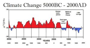
Research is surfacing that shows Antarctica may have been without ice during the Medieval Warming Period some refer to as the Medieval Climate Anomaly (MCA) which took place between 1000–1200 AD. Mapping the MCA across the Antarctic region based on the analysis of published palaeotemperature proxy data from 60 sites has revealed something which defies the global warming hysteria. They have used ice core data, temperature proxy records from marine and terrestrial sediment cores, as well as radiocarbon dating. They have discovered that there was in fact warming of Antarctica contrary to the belief that if the ice melted we would all drown.
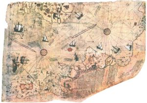
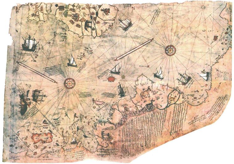
Back in 1773, the well-known explorer James Cook passed through the Antarctic circle for the first time. Cook officially discovered Antarctica which was generally believed to have been unknown. Later in 1929, a map was discovered in Istanbul that suggested it had been known before and has subsequently raised confirming evidence that Antarctica, at least in the West, was without ice and was noted as being a warm climate.
The chart was originally discovered in Istanbul while the German theologian Gustav Deissmann was cataloging the contents of Istanbul’s Topaki Palace’s library. He came across bundles of maps and charts that had been hidden within piles of disregarded materials. He was apparently stunned after realizing the staggering importance of this find for it was long understood that even Christopher Columbus possessed maps from the ancient world whose last capital was Constantinople – Istanbul. Constantinople fell to the Turks in 1453 and the scholars fled to Europe and to Russia and began teaching lost knowledge. This is what inspired Columbus to set sail in 1492.
Deissmann understood the importance of this map and he immediately brought it to an expert. The map was identified as the Piri Reis Map, taking its name from the medieval cartographer Piri Reis, who signed the bottom. The Piri Reis Map was astonishing for it apparently identified Antarctica at least 200 years before Cook’s discovery.
 The Piri Reis Map is a world map compiled in 1513 from military intelligence. Only about one-third of the map has survived displaying the western coasts of Europe and North Africa as well as the coast of Brazil with reasonable accuracy. There are also various Atlantic islands, including the Azores and Canary Islands. Naturally, academics tried to call it a fake because it disturbed their idealized linear timeline of discovery. Nonetheless, Gregory McIntosh, who is a historian of cartography, examined the map in detail in his book “The Piri Reis Map of 1513″ (University of Georgia Press, 2000). McIntosh was able to discover the sources for much of the map in Columbus’s writings. There were some errors, such as the Virgin Islands in two locations which he attributed to the use of multiple maps as sources. Nevertheless, McIntosh traced the accuracy of the depiction of the Antarctic coast. He noted that there were two errors insofar as the coast was shown perhaps hundreds of kilometers north of its proper location and that the Drake Passage was completely missing.
Of course, with Google Maps, people have uncovered what they are claiming are man-made pyramids in Antarctica, claiming that it was once inhabited perhaps 6,000 ago and a polar shift changed the landscape of the world. This is an interesting theory, but it remains just speculation. Sure, something like that could have happened. However, there is no way to prove such a theory at this point in time, leaving it as a plot for a speculative movie.
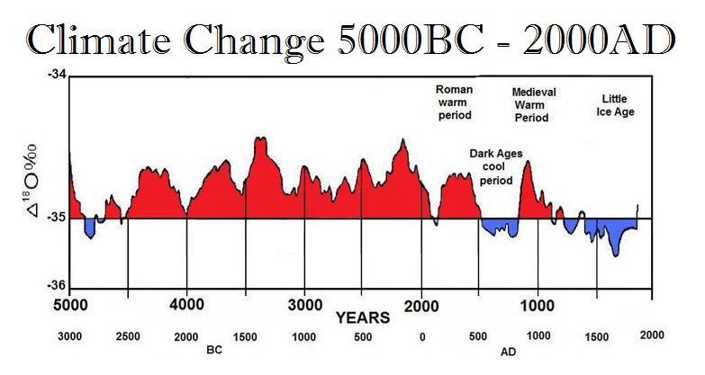
 Still, the Piri Reis Maphas baffled many because it stands in direct contrast with our perception today that the Antarctic is frigid but the notes on the map describe the region as having a warm climate. However, the map corresponds to the Medieval Warm Period that followed the Dark Ages and the Black Plague which wiped out about 50% of the population during the cold period.
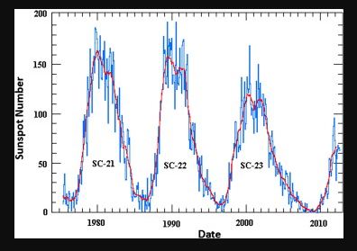
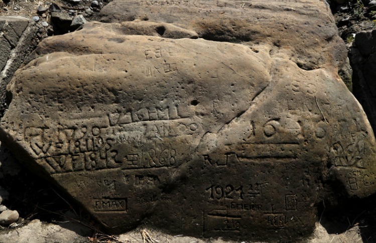
However, the extreme swings from heat to extreme cold (Panic Cycles) appear to be indicative of a precursor to Climate Change. Another piece of historical evidence for the Medieval Warming Period which has been ignored by the Global Warming crowd is known as the Hunger Stones. Pictured here is a Hunger Stone from 1616 which has been exposed by the low level of water in the Elbe River in 2018. This is at Decin, in the Czech Republic. Throughout the centuries, there have been these cycles of extreme heat followed by extreme cold. Such events have been recorded when drought has resulted in the low level of water in the Elbe river.
Then there is what many call the Christopher Columbus Map which is undated, but there are clues it was created in 1491: The Smithsonian reported that the map quotes a book published that year, and Christopher Columbus may have consulted the map (or a copy) before his great voyage. When he landed in the Bahamas, he believed he was close to Japan, for this map did not show the Americas. The map, made by a German working in Florence named Henricus Martellus, has been another map which has been ignored by academics.
Scientists at Yale University have been using multispectral imaging on this 15th-century map believed to have been used by Christopher Columbus. They have uncovered hundreds of place names and more than 60 written passages. I have written before that 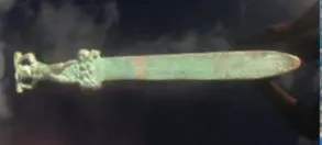 Roman artifacts have been discovered also in Canada. This clearly establishes that the ancient Romans may have sailed across the Atlantic long before Columbus or the Vikings. This discovery in Canada has created a storm for it rewrites history. The unquestionable discovery of a Roman sword in Canada is rather stark evidence that history is different from what academics believed. Yet Roman coins have been also discovered in Japan. Then there was the discovery of the Cocaine Mummies from Egypt which have confirmed there was trade between Africa and South America, although it could have been through the Pacific to India and off to Egypt.
Only two historical cases of pre-Columbian contact are widely accepted among the scientific mainstream. They have accepted maritime explorations by Norse peoples from Scandinavia during the late 10th century which led to the Norse colonization of Greenland and of L’Anse aux Meadows in Newfoundland which predate Columbus’ arrival in the Americas by some 500 years.
From China, we have historical evidence that the Roman Emperor Marcus Aurelius sent a diplomat envoy to establish contact with China, which they were long trading with through intermediaries on what was called the Silk Road. The history of Rome that it claimed to rule the world (orbis terrarum) stood at the opposite end of the globe from the strikingly similar Han Dynasty (206BC-220 AD) in China, which also claimed to have ruled the world (tianxia). There is the History Book for Tang-Dynasty in China covering the period 618-907 AD. Yet the text mentions 17 times what appears to be the Roman Empire. It also describes an envoy that was sent by the Roman Emperor to China. The Roman Emperor was recorded to have been “Anton.” The account of such an envoy who visited the older Han Dynasty predates the Venetian traveler Marco Polo (1254-1325) by more than 1,000 years. This envoy has been attributed to 166 AD during the reign of Marcus Aurelius Antoninus (121-180 AD). It is the death of Marcus Aurelius that has marked the peak in the Roman Empire and the turning point that begins the Decline and Fall of the Roman Empire where the monetary system collapses just 72 years thereafter. This envoy established diplomatic contact at the peak in the Roman Empire from which a disastrous decline begins. Any political-economic aspirations to further such a relationship would then die with Marcus Aurelius. Yet also, both empires would suffer the same fate of barbarian invasions. The Han Dynasty falls in 220 AD from which emerges the chaotic period known as the Three Kingdoms (220-280 AD ) – the division of the once unified Chinese Empire.
 The Minoan society began the Bronze Age. To make bronze, they needed tin. Low and behold, the Minoans traded with the British of Stonehenge Age period prior to 1650 BC, sailing into the Atlantic and they too must have created maps of the areas they sailed to. It was essential to sail into the Atlantic for trade giving birth to the Bronze Age.
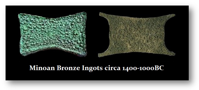
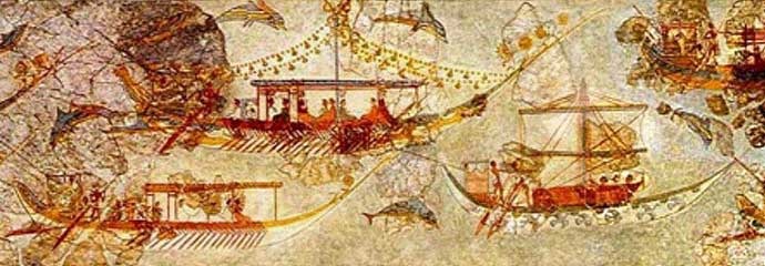
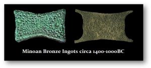
The Minoans were perhaps the first International Economy. They traded far and wide even with Britain seeking tin. Their civilization was of the Bronze Age rising civilization that arose on the island of Crete and flourished from approximately the 27th century BC to the 15th century BC. Their trading range and colonization extended to Spain, Egypt, Israel (Canaan), Syria (Levantine), Greece, Rhodes, and of course to Turkey (Anatolia). Many other cultures referred to them as the people from the islands in the middle of the sea. However, the Minoans had no mineral deposits. They lacked gold as well as silver or even the ability to produce large mining of copper. What has survived are examples of copper ingots that served as MONEY in trade.

The fall of the Minoan Civilization coincided with the eruption of Thera (today it is known as Santorini). This destroyed their ships and commerce and allowed the barbarians, then the Greeks from Mycenae, to plunder their society and also that of Troy before collapsing into a Dark Age due to climate change and global cooling. What is very clear is that there must have been maps which long predated the Piri Reis Map which apparently relied on numerous maps which had previously existed.
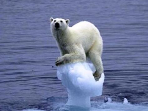
The latest is again they assumed the ice will all melt and the seas level will rise by 25 meters. They claim that if emissions don’t start to fall until 2030 and the world does not abide by the 2015 Paris Agreement, where anyone who disagreed was not allowed to present anything or speak, then the sea level will rise by 25 meters by 2050. This all opinion and no proof or historical evidence has ever been presented to show what would happen.