Posted originally on the conservative tree house on September 29, 2022 | Menagerie
For Sundance, who never fails to give thanks, in all circumstances. He has posted versions of this many times.
Posted in Uncategorized

For Sundance, who never fails to give thanks, in all circumstances. He has posted versions of this many times.
Posted in Uncategorized

As many long-time readers will know, we do have a little bit more than average experience dealing with the aftermath of hurricanes. I am not an expert in the before part; you need to heed the local, very local, professionals who will guide you through any preparation, and neighborhood specific guidelines, for your immediate area.
But when it comes to the ‘after part’, well, as a long-time CERT recovery member perhaps I can guide you through the expectation and you might find some value.
Consider this little word salad a buffet. If you are new to Florida hurricanes, absorb what might be of value pass over anything else.
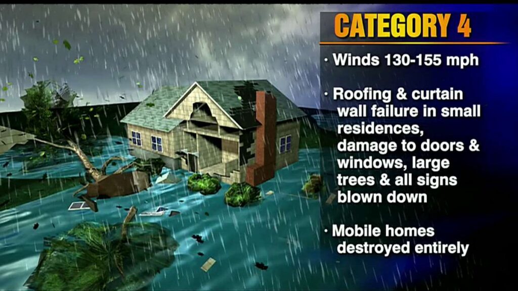
A category-4 storm can and will erase structures, buildings and landscape.
Hurricane Ian is similar to Hurricane Charley which impacted the SW coast of Florida in 2004, only a longer duration and therefore worse. The coastal topography and barrier islands will likely change in the 40-mile-wide area of immediate impact.
Sanibel Island, Bonita Beach, Fort Myers Beach, Captiva, Upper Captiva, Boca Grande, Pine Island, Cape Coral, Siesta Key, Longboat Key, Charlotte Harbor and Pine Island Sound could all be impacted.
There is the potential for 18+ hours of hurricane force winds and two tides with storm surges. Total infrastructure failure should be anticipated, and it will take weeks for restoration. The coastal communities are the most vulnerable; however, the inland impact of the storm will continue unimpeded until the eyewall crosses onto land.
That means communities inland for roughly 50 miles could likely see consistent hurricane force winds for several hours. That scale of sustained wind energy will snap power poles and weaken reinforced concrete.
As the backside of the storm then reverses the energy direction, any already compromised structures will not withstand the additional pressure. In many cases the backside of the storm is worse than the front. If you are inland, you too should prepare yourself for long duration of extensive wind damage followed by an extended power outage.
For those who are in the path of the storm, there comes a time when all options are removed, and you enter the “Hunkering Down” phase. You’re there now.

Unfortunately, unlike Charley, this particular hurricane Ian will stick around for more than the 2+ hours of the 2004 storm event. That brings a serious problem with coastal storm surge (two tidal cycles). In its totality from initial impact through recovery this is going to be a long-duration event.
When the sustained winds reach around 45mph only the more dire of emergencies get an immediate response. It is almost a guarantee that around the time emergency responders stop responding, too dangerous, you will lose power from the storm. Do not expect the power to be turned back on until it is safe, in this example recovery will be delayed by the slow forward progress of the storm.
Hurricanes can be frightening; downright scary. There’s nothing quite like going through a few to reset your outlook on just how Mother Nature can deliver a cleansing cycle to an entire geographic region. The sounds are scary. Try to stay calm despite the nervousness. Telephone and power poles, yes, even the concrete ones, can, and likely will, snap like toothpicks.
The ground in Southwest Florida is also completely saturated with heavy rains even before the storm began dumping water earlier on Monday. Trees that previously withstood Irma and even Charley, could likely bend, uproot and break; the sounds are dramatic.
There’s a specific sound when you are inside a hurricane that you can never forget. It isn’t a howl, it’s a roar. It is very unique sound in depth and weight. Yes, within a hurricane wind has weight. Stay clear of windows and doors, and within an interior room of the house or apartment if possible.
That scary roar will sound like it will never quit, especially for this specific slow-moving hurricane. It will stop, eventually; but at the time you are hunkering down, it doesn’t seem like it will ever end. This is the part that makes people say they will never go through that again. It is intensely unnerving. Imagine being impacted by a tornado for a full day.
A hurricane wind is a constant and pure rage of wind that doesn’t ebb and flow like normal wind and storms.
Hurricane wind is heavy, it starts, builds and stays, sometimes for hours. This one is forecast to be the longest in my memory. The wind is relentless, it just seems like it won’t let up. And then, depending on Ian’s irrelevant opinion toward your insignificant presence, it will stop.
Judging by the forward speed being stated by professionals at the National Hurricane Center, the hurricane force wind will likely last around 18 hours before it stops. Prepare your nerves as best you can for this.
Then silence. No birds. No frogs. No crickets. No sound.
Nature goes mute. It’s weird.
We have no idea how much ambient noise is around us, until it stops.

Due to the speed of this storm, there will be convoys coming to construct a pre-planned electricity grid recovery process around nightfall Thursday. Convoys from every city, town and state from the east-coast to the mid-west. A glorious melding of dirty fingernails all arriving for the meet-up. Depending on your proximity to the bigger picture objectives at hand, you will cherish their arrival.
But first, there will be an assessment. The convoys will stage at pre-determined locations using radios for communication. Most cell phone services will likely be knocked out. Recovery teams will begin a street-by-street review; everything needs to be evaluated prior to thinking about beginning to rebuild a grid. Your patience within this process is needed; heck, it isn’t like you’ve got a choice in the matter…. so just stay positive.
Meanwhile, you might walk outside and find yourself a stranger in your neighborhood.
It will all be cattywampus.
Trees gone, signs gone, crap everywhere, if you don’t need to travel, DON’T.
I mean CRAP e.v.e.r.y.w.h.e.r.e.
Stay away from powerlines.
Try to stay within your immediate neighborhood for the first 36-48 hours after the storm passes. Keep the roadways and main arteries clear for recovery workers, power companies and fuel trucks.
However, be entirely prepared to be lost in your own neighborhood and town for days, weeks, and even months. Unknown to you – your subconscious mind is like a human GPS mapping system. When that raging Ian takes away the subconscious landmarks I guarantee you – you are going to get lost, make wrong turns, miss the exit etc.
It’s kind of funny and weird at the same time.
Your brain is wired to turn left at the big oak next to the Church, and the road to your house is likely two streets past the 7-11 or Circle-k. You don’t even notice that’s how you travel around town; that’s just your brain working – it is what it is.

Well, now the big oak is gone; so too is the Circle-K and 7-11 signs. Like I said, everything is cattywampus. Your brain-memory will need to reboot and rewire. In the interim, you’re going to get lost… don’t get frustrated.
No street signs. Likely no stop signs. No traffic lights.
Remember, when it is safe to drive, every single intersection must be treated like a four-way stop…. and YOU ARE GOING TO HAVE TO PAY ATTENTION. Even the major intersections.
You’ll need to override your brain tendency to use memory in transit. You’ll need to pay close attention and watch for those who aren’t paying close attention.
Travel sparingly, it’s just safer.
Check on your-self first, then your neighbors. It doesn’t matter if you’ve never said a word to the guy in the blue house before. It ain’t normalville now.
Break out of your box and check on the blue house down the street too. In the aftermath, there’s no class structure. Without power, the big fancy house on the corner with a pool is just a bigger mess. Everyone is equally a mess.
The first responders in your neighborhood are YOU.
You, the wife, your family, Mrs. Wilson next door; Joe down the street; Bob’s twin boys and the gal with the red car are all in this together. If you don’t ordinarily cotton to toxic masculinity, you will worship its appearance in the aftermath of a hurricane. Git-r-done lives there.
Don’t stand around griping with a 40′ tree blocking the main road to your neighborhood. Figure out who’s got chainsaws, who knows how to correctly use them, and set about safely clearing the road. If every neighborhood starts clearing their own roadways, the recovery crews can then move in for the details.
Stage one focuses on major arteries… then secondary… then neighborhood etc. It’s a process.
Oh, and don’t get mad if your fancy mailbox is ploughed over by a focused front-end loader who is on a priority mission to clear a path. Just deal with it. Those same front-end loaders will also be removing feet of sand from coastal roads. Don’t go sightseeing… stay in your neighborhood.
For the first 36-48 hours, please try to stay close to home, in your neighborhood. Another reason to stay close to home is the sketchy people who can sometimes surface, looters etc. Staying close to home and having contact with your neighbors is just reasonable and safer.
Phase-1 recovery is necessarily, well, scruffy…. we’re just moving and managing the mess; not trying to clean it up yet. It’ll be ok. There are going to be roofing nails everywhere, and you will likely get multiple flat tires in the weeks after the hurricane.
After this storm half of the people living near Cape Coral, Punta Gorda and Port Charlotte are going to fit into two categories, two types of people: (1) those with a new roof; or (2) those with a blue roof (tarp).
Keep a joyous heart filled with thankfulness; and if you can’t muster it, then just pretend. Don’t be a jerk. You will be surrounded by jerks…. elevate yourself. If you need to do a few minutes of cussing, take a walk. Keep your wits about you and stay calm.
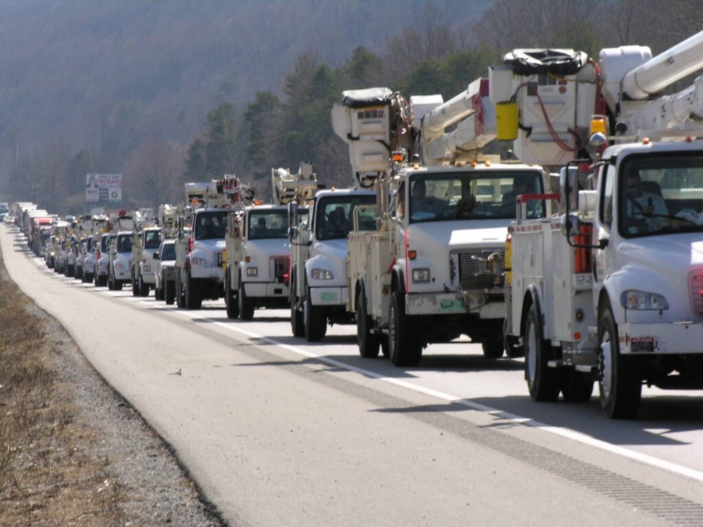
Now, when the recovery teams arrive…. If you are on the road and there’s a convoy of utility trucks on the road, pull over. Treat power trucks and tanker trucks like ambulances and emergency vehicles. Pull over, give them a clear road and let them pass.
When everyone gets to work, if you see a lineman, pole-digger or crew say thanks. Just simple “thanks”. Wave at them and give them a thumbs-up. No need to get unnecessarily familiar, a simple: “thank you for your help” will suffice. You know, ordinary people skills.
Many of these smaller crews will be sleeping in cots, or in their trucks while they are working never-ending shifts. Some will be staging at evacuation shelters, likely schools and such. The need to shelter people and recovery crews might also delay the re-opening of schools.
Once you eventually start getting power back, if you see a crew in a restaurant, same thing applies… “thanks guys”.
Same goes for the tanker truckers. The convenience stores with gas pumps are part of the priority network. Those will get power before other locales without power. Fuel outlets are a priority. Fuel is the lifeblood of recovery. Hospitals, first responders, emergency facilities, fuel outlets, then comes commercial and residential.
Remember, this is important – YOU are the first responder for your neighborhood. Don’t quit. Recovery is a process. Depending on the scale of the impact zone, the process can take days, weeks and even months.
Take care of your family first; then friends and neighborhood, and generally make a conscious decision to be a part of any needed solution.
Pray together and be strong together. Do not be bashful about being openly thankful in prayer.
It will be ok.
It might be a massive pain in the a**, but in the end, it’ll be ok.
√Andrew
√Jeanne
√Frances
√Ivan
√Charley
√Irma
√Michael
Ian
Keep a good thought. Who knows, we might even end up shaking hands.
It will be OK. Promise.
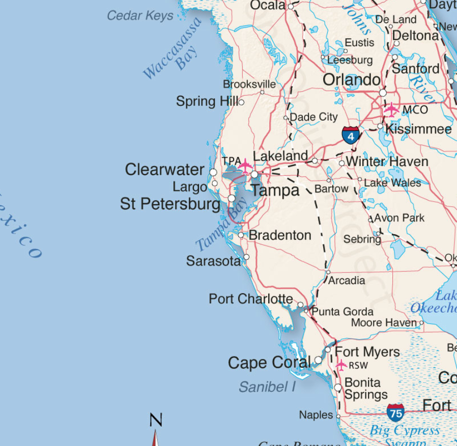
The projected path of Hurricane Ian, a category 4 storm, has now been narrowed. Landfall is anticipated just North of Cape Coral in the Punta Gorda, Port Charlotte area. Lee and Charlotte counties will likely feel greatest impact from Ian starting overnight through all day Wednesday, with eyewall entering Southwest Florida (SWFL) overnight Wednesday.
All preparations must be rushed to completion. Power outages will likely start sporadically happening early to midday tomorrow (Wed). Evacuation zones have been expanded due to increased storm surge prediction. Pay close attention to your local officials and local media. If you are staying in the Lee or Charlotte coastal area, now is the time to finish inside preparations. Local SWFL radar is now tracking storm [Local Media Link].

Boca Grande Pass, famous for exceptional Tarpon fishing, looks to be the immediate coastal area where the greatest wind driven storm surge will impact. Gulf water will be pushed up the Caloosahatchee and Peace rivers creating expanded flooding further inland. The flooding and storm are anticipated to be the largest in SWFL history and are the greatest risk.
(NHC) – Maximum sustained winds remain near 120 mph (195 km/h) with higher gusts. Ian is a category 3 hurricane on the Saffir-Simpson Hurricane Wind Scale. Re-strengthening is expected later today through Wednesday. Ian is forecast to approach the west coast of Florida as an extremely dangerous major hurricane. Hurricane-force winds extend outward up to 40 miles (65 km) from the center. (more)
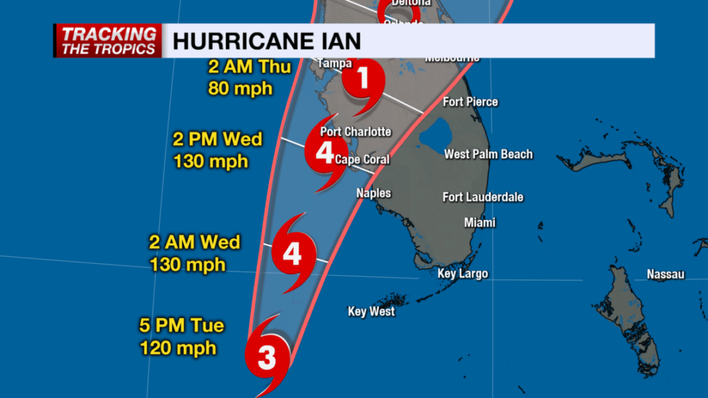
(NBC2 News) – Because of the location and movement of this hurricane, Lee and Charlotte and coastal Collier Counties are under hurricane warnings. It is important to stress: DO NOT FOCUS ON THE CENTER OF THE FORECAST CONE. IMPACTS FROM THIS HURRICANE WILL EXTEND FAR BEYOND WHERE THE CENTER OF THE STORM IS.
As of 5 p.m. Tuesday, the forecast cone has shifted east of where it was earlier today, meaning the potential of a Category 4 hurricane landfall is higher in Southwest Florida than it was 24 hours ago. (more)
Stage your battery powered lights and weather radios.
Turn down your refrigerator to its lowest setting anticipating power outage.
Freeze bottles of water to fill empty space in freezer.
Secure all important papers in waterproof bags and stage in central location.
Take a refreshing hot shower.
Fill cleaned and sanitized garbage cans with water in shower and/or bathtub.
Bring in outdoor furniture or throw it in the pool.
Put all your most critical items in an interior room without windows.
Put your most critical needed emergency items in easy reference place.
Elevate anything you might fear getting damaged from flooding.
Fully charge your portable electronics including cell phone.
Eat a good meal
Get rest tonight. Do not allow yourself to be overcome with dark imaginings.
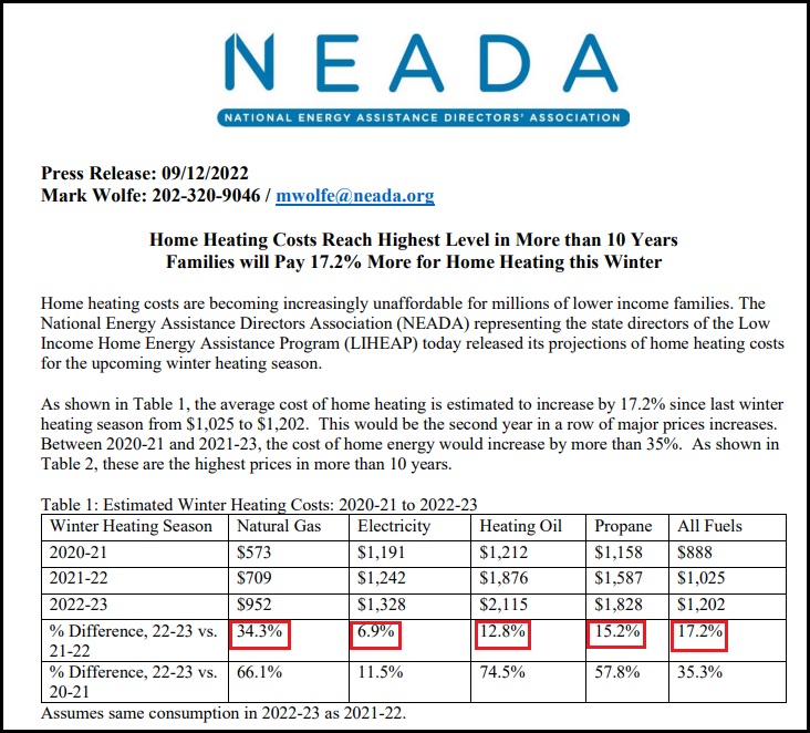
The National Energy Assistance Directors Association (NEADA) is estimating it will cost Wisconsin residents more than $1,200 to heat an average home this winter, an increase of more than 17% compared to last winter. [Data Link Here]
Roughly 50% of Wisconsin residents use natural gas for home heating. Natural Gas heating costs are increasing 34% this year (vs last winter, 2021). That’s also a 66.1% increase over the winter of 2020.


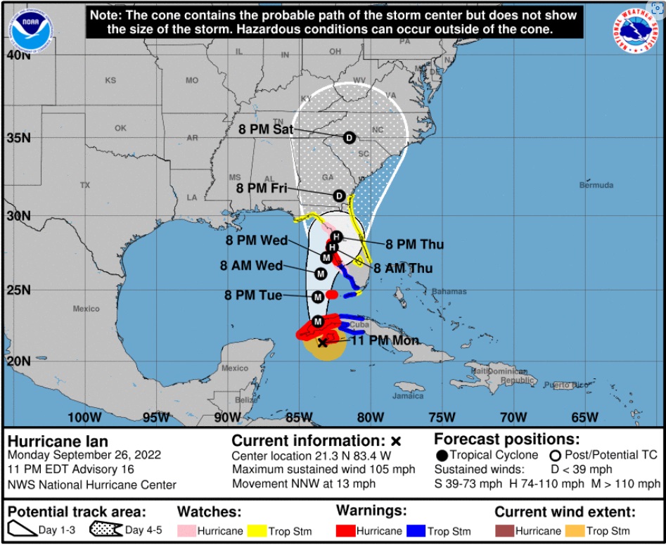
[National Hurricane Center Data] As of 11:00pm ET Monday, Hurricane Ian has maximum sustained winds of 105 mph [Category 2]. Ian is anticipated to strengthen rapidly in the next 24 hours as it enters the Gulf of Mexico as a major hurricane [Cat 3+]. All west coast Florida residents from Bonita Springs to Tampa should use Tuesday to finalize their hurricane preparations.
Tuesday is the last good weather day to finish your preparations and secure your property. Do not be alarmed but do take this hurricane seriously. This is not a ‘wait and see’ type storm. All reasonable precautions should be completed today, and all coastal residents are urged to pay close attention to local officials for any evacuation orders. Each locality is different, each coastal locality has a zone of potential flooding and storm surge. As a general rule, hunker down from wind – but evacuate from water.
Official projections put the storm just off the Florida west coast on Wednesday night, with the potential for a 24-hour duration cycle. That is an alarming amount of time for a major hurricane to be centered near or on the coast. That is a minimum of two tidal cycles, which will make a big difference from prior hurricanes in terms of flooding and the potential for a historic storm surge into inland waterways.
Hurricanes can be frightening; downright scary. There’s nothing quite like going through a few to reset your outlook on just how Mother Nature can deliver a cleansing cycle to an entire geographic region. If this storm rests on/near the coast for the projected duration (24 hrs), things could be much more sketchy than other hurricanes. This possibility is not something to dismiss. No one in Florida has a reference.
The geography on the south side of the storm faces the possibility of inbound wind and water for two tides, very uncommon. Additionally, with outbound water limited by the pressure of inbound tides, the Peace River will flood, potentially at a historic level. Let us hope the official forecasts are wrong, but we need to plan for this. Projected rainfall is up to ten inches.
The deepest water will occur along the immediate coast near and to the right of the center, where the surge will be accompanied by large waves. Surge-related flooding depends on the relative timing of the surge and the tidal cycle, and can vary greatly over short distances. For information specific to your area, please see products issued by your local National Weather Service forecast office. [HERE’S LINK] Pay attention to local officials.
Do not panic, but work your plan.
Dangerous coastal area storm surges are now predicted from Fort Myers north into Tampa Bay (south side of storm). Please outline your communication plan with your family. Select a specific person outside the area to be your immediate contact. That person then relays information to the rest of your family. Please do this [Example Why].
Right now, you are in control. Do not be alarmed – but take every preventative measure your individual situation needs. Work your hurricane plan and stay focused on what you do control. Work the plan, step by step and focus on what is in front of you. Ignore the dark imaginings and turn off the national media. Pay attention to your local officials and local media.
Finish your laundry. Sanitize and stage your water storage. Inventory your supplies. Organize your tools. Fill your freezer with water jugs to take up room and freeze. Test your generator. Stage your extension cords. Stage your battery powered devices. Test your weather radio. Take small steps to prepare. Secure your home. You are in full control. Today is the day to finish all preparation tasks.
The #1 priority is to keep calm. Keep stable. If other people around you are panicked, do not let it impact your plan. Stay focused. Stay organized. Stay in control. I cannot emphasize enough how important it is for everyone around you and your family. Everything is replaceable, except you and your family. We have a lot of Treepers in the path of this storm. If you need assistance, use the comments section of any ‘Update thread’ to reach out, or use the email address in the upper right of the site.
DAY THREE (Tue/Wed)
.
Communication is important. Update your friends and family contact list. Stay in touch with family and friends, let them know your plans. Select a single point of contact for communication from you that all others can then contact for updates if needed.
Telephone and power poles, yes, even the concrete ones, can, and likely will, snap like toothpicks. There’s a sound when you are inside a hurricane that you can never forget.
It ain’t a howling wind, it’s a roar. A damn scary raging roar that just won’t quit….
It will quit… eventually… but at the time you are hearing it, it doesn’t seem like it will ever end.
A constant and pure rage of scary wind that doesn’t ebb and flow like normal wind and storms… hurricane wind just starts and stays, sometimes for hours.
This type of wind is relentless and damn scary. It takes you to that state where you begin to doubt things, it just won’t let up.
And then, depending on her irrelevant opinion toward your insignificant presence, she stops.
Then silence.
No birds. No frogs. No crickets. No sound.
Nature goes mute. It’s weird.
We have no idea how much ambient noise is around us, until it stops.
Oh, if she wants, she’ll keep dumping buckets on you as she wanders away. Buckets. Not pails, garbage can size buckets. After the scour, yup, nature too has a rinse cycle.
Prayers for all those in Ian’s path.
Pray together and be strong together. It might sound goofy to some, but don’t be bashful about prayer – it works.
It will be ok.

Last point, housekeeping. Most of the long-term Treepers know I will likely be unavailable as Civilian Emergency Response Teams (CERT) are activated. The daily threads are auto scheduled to post, and the site admins will update on events if/when I am unavailable. My apologies to those who have written complaining that CTH is not providing the comprehensive coverage of political news.
Unfortunately, home base for all current research will consist of three duffel bags, a laptop, generator and a well-suited 4×4; loaded with power tools, emergency kits and assorted roughneck supplies. I will make every effort to return to political research and analysis – as soon as current logistics, community safety and overall concerns are abated. As part of FL CERT, we reposition outside of the storm surge area. As a consequence, during the logistical move I will be out of the loop for most of the morning and early afternoon Tuesday.
To ensure continuance of communication, CTH has auto-scheduled posts set up throughout the week which will run automatically without any need for human data entry. [ie. the website is secure and will function as normal – and site admins are disbursed throughout unaffected time zones] Other than my absence (hopefully sporadic), you should not see any disruption.
What can YOU DO?
Please pray for the people of Florida. This is an extremely stressful time for many people, including a significant amount of elderly. Unfortunately, due to modern disconnection a considerable number of people do not have frequent contact with family, COVID made this issue worse.
If you know people in Florida, please just reach out to them via social media, email, text, etc and let them know they are in your thoughts and prayers. You don’t have to call them, you don’t need to look for a response, but a short note -just touching base- via social media (Facebook etc.), with kind words, can mean the world to people who might be feeling isolated.
Trust me, I’ve seen those faces all day. It matters.

With the forecasted path of Hurricane Ian anticipated to bring high water and winds to the west coast of Florida there is the potential for major storm surge in specific regions. Florida Governor Ron DeSantis held a press conference from Pinellas County to outline the latest information. WATCH:
TALLAHASSEE, Fla. — This morning, Governor Ron DeSantis issued updates on Hurricane Ian at the State Emergency Operations Center with Florida Division of Emergency Management Director Kevin Guthrie. Full remarks from this morning’s press conference are available here.

Hurricane Ian became a Category 1 hurricane this morning and is projected to continue strengthening into a major hurricane this week. Tropical-storm force winds may begin as soon as tonight in the Florida Keys and southern Florida. Regardless of Ian’s exact track and intensity, there is a significant risk of life-threatening storm surge, hurricane-force winds, and heavy rainfall along the west coast of Florida and the Florida Panhandle by the middle of this week.
Current Watches and Warnings in Effect:
State preparation and response efforts include:
Florida Division of Emergency Management (FDEM)
Florida National Guard
Florida Department of Health (DOH)
Agency for Health Care Administration (AHCA)
Agency for Persons with Disabilities (APD)
Florida Department of Children and Families (DCF)
Florida Department of Veterans Affairs (FDVA)
Florida Department of Transportation (FDOT)
Florida Department of Highway Safety
and Motor Vehicles (FLHSMV)
Florida Wildlife Commission (FWC)
Florida Department of Economic Opportunity (DEO)
Florida Department of Environmental Protection (DEP)
Florida Department of Education (DOE)
The Florida Department of Education is consistently updating their website with county school closures, for a list visit fldoe.org/storminfo.
K12 School Closures
Florida College System Closures
State University Closures
Florida Department of Management Services (DMS)
Posted in FEMA, Hurricane Ian, Ron DeSantis, Uncategorized

The Bank of England (BoE) all but admitted the UK is officially in a recession. Bank Governor Andrew Bailey stated weeks ago that there was nothing the central bank could do to prevent a recession at this stage. The Monetary Policy Committee (MPC) voted to raise rates by half a percentage point to 2.25%, marking the highest level since 2008. The markets were expecting a 75 bps hike, but the central bank is moving slowly and aiming to avoid panic.
The central bank foresees a 0.1% drop in GDP over the next three months after experiencing a 0.1% decline last quarter. The CPI report for August came in at 9.9%, which is only a slight drop from July’s 10.1% reading. Winter is coming, and that is when the full impact of the energy crisis will be felt. The BoE believes inflation will rise to 11% in October when energy caps are altered. Like the Federal Reserve, the BOE is a long way from its 2% inflation target and relied on QE for far too long.
The dollar’s strength continues to cause a devaluation in sterling as the USD is seen as the last safe haven.
The DeSantis Crew, formerly the 2016 Cruz Crew, is up in arms over a selectively edited soundbite from Jared Kusher, President Trump’s son-in-law. {Direct Rumble Link}
Florida Governor Ron DeSantis went shopping for South American aliens at an El Paso migrant processing facility in Texas. The DeSantis people took the aliens to a hotel with plans to fly them to Delaware, Joe Biden’s home state. However, facing backlash over the legality of spending Florida funds on a previous operation to move Texas migrants to Martha’s Vineyard, the DeSantis team abandoned the recruited Venezuelan aliens at the hotel, leaving them confused and stranded.
Jared Kushner noted in a Fox appearance that he did not like the approach of recruiting, manipulating and using arriving aliens as political pawns. Immediately the DeSantis supporters pulled an 8-second soundbite from a one-hour Fox News appearance and proclaimed Kusher was criticizing Ron DeSantis, which in the world view of Team DeSantis makes Kushner an enemy. However, the full statement with context is not controversial at all, and in my opinion Kusher is correct. WATCH:
.
The fact that Ron DeSantis sent people to Texas to recruit aliens from an El Paso processing facility with the promise of a flight to Delaware, then abandoned them when the political heat started, literally leaving them at the hotel confused and waiting for a bus that never arrived, shows the operation itself was using aliens as “political pawns,” and it is unseemly.
The DeSantis people can try to spin this against Kushner, but the outrage should really be toward the people working for DeSantis who pulled this stunt.

National Grid and Eversource are the two major electricity providers for Massachusetts. Both companies have notified the Department of Public Utilities (DPU) that rates for electricity are about to skyrocket.
National Grid has announced a 64% increase in electricity rates effective November 1st. While Eversource is on a different schedule, they too have announced an increase in natural gas rates of 38% on November 1st and the January 1, 2023, electricity rate will be announced in the next few weeks. Eversource is anticipated to announce a similar rate increase to National Grid. WATCH:
Both major power companies rely on natural gas to create electricity. Thanks to Joe Biden’s energy policies, which includes the massive export of natural gas in LNG form, domestic prices for natural gas have skyrocketed and will continue increasing as production is further shut down by regulation.
We are helping the EU survive their sanction driven energy crisis by sending them natural gas (LNG format), while simultaneously forcing Americans to pay more in order to maintain the EU export. Everything about the process is FUBAR.
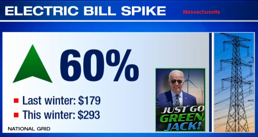
Massachusetts – […] National Grid said the monthly bill of a typical residential customer using 600 kilowatt-hours of electricity will increase from $179 last winter to about $293 this winter, an increase of about 64%. National Grid said the delivery portion of electric bills will basically remain flat.
“National Grid buys electricity on behalf of its customers from the wholesale power market through a regulatory approved process established 20 years ago. That process has served customers well over the years and provides flexibility for unforeseen events, like limited supplier response to solicitations. But things have fundamentally changed,” Helen Burt, the company’s chief customer officer, said in a statement. “Today, under a sustained, high market price environment, it is challenging to maintain affordable prices. Given that, we think it’s a good time to work with our regulators and other stakeholders to review the process and electricity supply dynamics in the region, with an eye toward reducing price volatility and maintaining a secure, reliable and resilient energy system for the future.”
The company also announced that its natural gas rates are expected to rise on Nov. 1. They said they have a pending proposal with the state Department of Public Utilities that would result in the monthly bill for an average Boston Gas residential heating customer using 115 therms per month of $278, an increase of $50, or 22%, compared to last winter’s rates.
Eversource, the state’s other major electric provider, said in an email that it is on a different schedule than National Grid for setting its electric rates so no increases are currently planned.
“We file electric base service rates twice per year with the DPU,” company spokesman Chris McKinnon said. “Our last change was on July 1, 2022 and our next change will be January 1, 2023, which we will be filing for in the coming months.”
Over the border in New Hampshire, Eversource announced in July that electric rates would be doubling for many residents due to higher natural gas prices fueled in part by the war in Ukraine.
Eversource did announce Wednesday that it has submitted a proposal to the Department of Public Utilities seeking to raise its natural gas rates. They said their average residential customer using 126 therms of gas a month would see an increase of about 38%, or $86 on their natural gas bill over last winter. Those rate increases would take effect Nov. 1. (read m0re)

From the attached report on climate change for August 2022 Data we have the two charts showing how much the global temperature has actually gone up since we started to measure CO2 in the atmosphere in 1958? To show this graphically Chart 8a was constructed by plotting CO2 as a percent increase from when it was first measured in 1958, the Black plot, the scale is on the left and it shows CO2 going up by about 32.0% from 1958 to August of 2022. That is a very large change as anyone would have to agree. Now how about temperature, well when we look at the percentage change in temperature also from 1958, using Kelvin (which does measure the change in heat), we find that the changes in global temperature (heat) is almost un-measurable at only .4%.

As you see the increase in energy, heat, is not visually observably in this chart hence the need for another Chart 8 to show the minuscule increase in thermal energy shown by NASA in relationship to the change in CO2 Shown in the next Chart using a different scale.

This is Chart 8 which is the same as Chart 8a except for the scales. The scale on the right side had to be expanded 10 times (the range is 50 % on the left and 5% on the right) to be able to see the plot in the same chart in any detail. The red plot, starting in 1958, shows that the thermal energy in the earth’s atmosphere increased by .40%; while CO2 has increased by 32.0% which is 80 times that of the increase in temperature. So is there really a meaningful link between them that would give as a major problem?
Based to these trends, determined by excel not me, in 2028 CO2 will be 428 ppm and temperatures will be a bit over 15.0o Celsius and in 2038 CO2 will be 458 ppm and temperatures will be 15.6O Celsius.
The full 40 page report explains how these charts were developed .
I have created this site to help people have fun in the kitchen. I write about enjoying life both in and out of my kitchen. Life is short! Make the most of it and enjoy!
De Oppresso Liber
A group of Americans united by our commitment to Freedom, Constitutional Governance, and Civic Duty.
Share the truth at whatever cost.
De Oppresso Liber
Uncensored updates on world events, economics, the environment and medicine
De Oppresso Liber
This is a library of News Events not reported by the Main Stream Media documenting & connecting the dots on How the Obama Marxist Liberal agenda is destroying America
Australia's Front Line | Since 2011
See what War is like and how it affects our Warriors
Nwo News, End Time, Deep State, World News, No Fake News
De Oppresso Liber
Politics | Talk | Opinion - Contact Info: stellasplace@wowway.com
Exposition and Encouragement
The Physician Wellness Movement and Illegitimate Authority: The Need for Revolt and Reconstruction
Real Estate Lending
