Posted originally on the conservative tree house on November 9, 2022 | Sundance
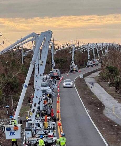
Hurricane conditions are expected from Boca Raton to Flagler/Volusia County line along the coast in Florida tonight. However, do not focus only on the center of the storm. Hurricane winds extend 25 miles from center, tropical storm winds 400+ miles from center, and massive rain are anticipated over central Florida with significant flooding north of Lake O. Residents along coastal and inland waterways should be fully prepared for this storm. Overnight conditions will deteriorate rapidly.
At 1000 PM EST (0300 UTC), the center of Hurricane Nicole was located near latitude 27.0 North, longitude 78.9 West. Nicole is moving toward the west-northwest near 13 mph (20 km/h). A turn toward the northwest is expected on Thursday, followed by a turn toward the north and north-northeast on Friday.
On the forecast track, the center of Nicole will move onshore the east coast of Florida within the hurricane warning area late tonight or early Thursday. Nicole’s center is then expected to move across central and northern Florida into southern Georgia Thursday and Thursday night, and into the Carolinas Friday.
Maximum sustained winds are near 75 mph (120 km/h) with higher gusts. Little change in strength is expected until Nicole makes landfall along the Florida east coast. Nicole is expected to weaken while moving across Florida and the southeastern United States Thursday through Friday, and it is likely to become a post-tropical cyclone by Friday afternoon. (more)
Many of us have spent the past 36 hrs preparing for this storm; however, my gut is telling me many are not ready for the potential flooding from Nicole. Toolboxes and supplies are loaded, and relief/recovery supplies staged south of Lake-O are prepared to move north as needed.
Now, is when the southeast and southcentral east coast needs to hunker down in safe, secure and hardened structures away from the water.
Power is likely to be lost along the coastal and near coastal areas of Florida as well as central Florida north of Lake-O. Stay inside during the storm passing and pay attention to local officials for instructions related to road closures and transit corridors.
East coast of Florida Treepers, if you find yourself in an emergency situation, feel free to reach out in the comment section or email directly.
Keep a good thought, all will be okay.
I know it is unnerving when these storms move in at night, but everything will be okay. Nicole will hopefully pass through quickly, but the rain, ground saturation and potential for flooding may be problematic for several days.
Hurricanes can be frightening; downright scary. There’s nothing quite like going through a few to reset your outlook on just how Mother Nature can deliver a cleansing cycle to an entire geographic region. The sounds are scary. Try to stay calm despite the nervousness. Trees will bend and break; the sounds are dramatic.
If you are near the eyewall, there’s a specific sound when you are inside a hurricane that you can never forget. It ain’t a howl, it’s a roar. It is very unique sound in depth and weight. Yes, within a hurricane wind has weight. Stay clear of windows and doors, and within an interior room of the house or apartment if possible.
That scary roar sounds like it won’t ever quit…. it will… eventually; but at the time you are hunkering down, it doesn’t seem like it will ever end.
A hurricane wind, even a moderate one, is a constant and pure rage of wind that doesn’t ebb and flow like normal wind and storms. Hurricane wind is heavy, it starts, builds and stays; sometimes for hours. Relentless, it just won’t let up. And then, depending on Nicole’s irrelevant opinion toward your insignificant presence, it will stop.
Judging by the forward speed the hurricane force winds will likely last around 2 hours before she lets up.
Meanwhile, tomorrow you might walk outside and find yourself a stranger in your messed up neighborhood. It will all be cattywampus. Trees gone, signs gone, crap everywhere, if you don’t need to travel, DON’T.
I mean CRAP e.v.e.r.y.w.h.e.r.e. Stay away from powerlines.
Try to stay within your immediate neighborhood for the first 36-48 hours. Keep the roadways and main arteries clear for recovery workers, power companies and relief trucks.
Remember, when it is safe to drive, if the power is out – every single intersection must be treated like a four-way stop…. and YOU ARE GOING TO HAVE TO PAY ATTENTION. Even the major intersections.
You’ll need to override your brain tendency to use memory in transit. You’ll need to pay close attention and watch for those who ain’t paying close attention. Travel sparingly, it’s just safer.
Remember, this is important – YOU are the first responder for your neighborhood. Don’t quit. Recovery is a process. Depending on the scale of the impact zone, the process can take days or weeks. Take care of your family first; then friends and neighborhood, and generally make a conscious decision to be a part of any needed solution.
Keep a good thought. Who knows, we might even end up shaking hands.
It might suck a little bit, but it will be okay. Promise.
DeSantis’ victory was really in the bag. However, the migration fleeing Wokeness outside Florida has changed the political map entirely. Miami Dade County has NEVER voted Republican in history. It voted for DeSantis. I moved to Florida 6 years ago. I did so when Socrates pinpointed that Florida would be the #1 state in the USA. My family was not so pleased, but I said I had to follow Socrates. The traffic here has doubled, which was not something I Cherish. Hedge Funds have been moving to Florida as well as the hidden secret – much of Wall Street moved to Florida.
This vote for DeSantis is remarkable in how the map has changed – not simply that he won by about 60%. I am glad I put my faith in Socrates. We have a diverse climate for those who think Florida is hot. The North gets cold in winter and it has even had snow on occasion. But by Tampa, you will still need a jacket in winter, and on some occasions, I have even had to turn the heat on.
This vote is historic for flipping Miami, but it is also important from the perspective of the flight from the Woke states. I have met people who fled up north because during COVID their children became so depressed and boys with dreams of sports careers even became suicidal. Others moved for freedom and the whole COVID scam destroyed people’s lives, small businesses, and careers. People who fled to Florida did so for a variety of reasons. Yet what I found astonishing was that Florida became the beacon of light around the world.
Those who would assume I would support DeSantis for President are wrong. They will eat him for lunch in DC. He is far more in control right here.
Posted originally on the conservative tree house on November 8, 2022 | Sundance
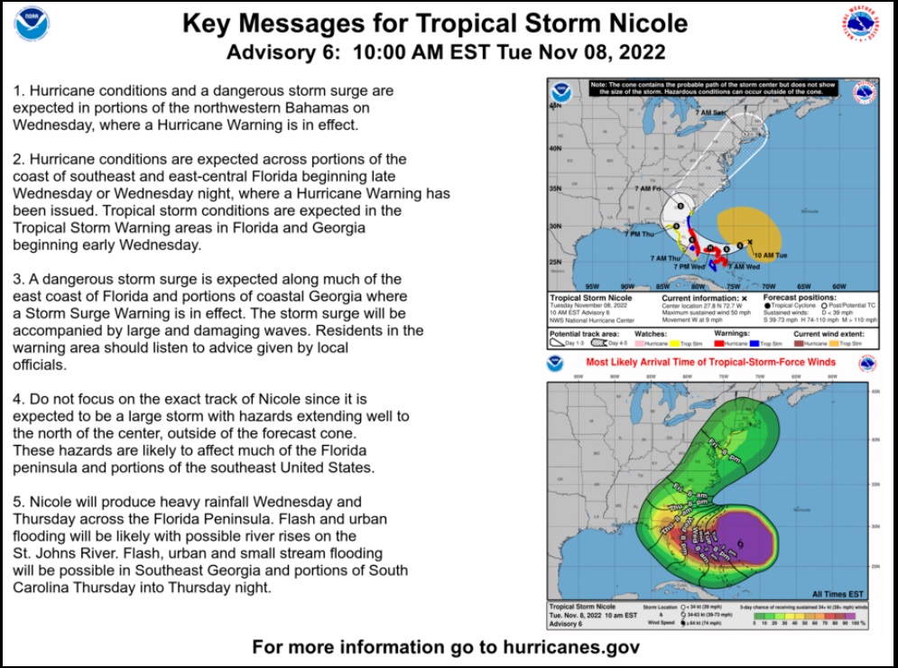
The National Hurricane Center is advising Florida east coast residents to prepare for hurricane conditions during the Wednesday overnight hours. [NHC Website] Tropical Storm Nicole is moving quickly toward the Bahamas and will approach the Florida east coast late Wednesday. Florida Governor Ron DeSantis has declared a state of emergency to release resources and trigger support mechanisms.
[NOTE: Florida West Coast – Nicole is a large system with tropical storm force winds extending for 380 miles from center. For SWFL residents in the debris and recovery zone from Ian, the winds from Nicole will be coming from the North, starting soon. Keep this in mind when securing already destabilized structures, roof tarps, fences, debris etc. Anticipate tropical storm force winds arriving from the North tomorrow.]
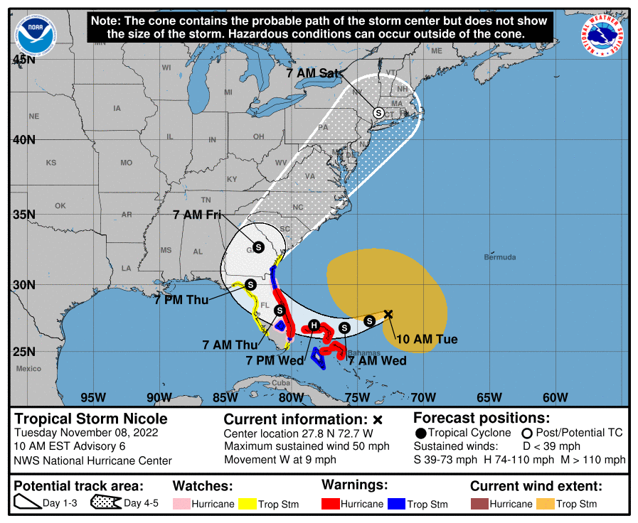
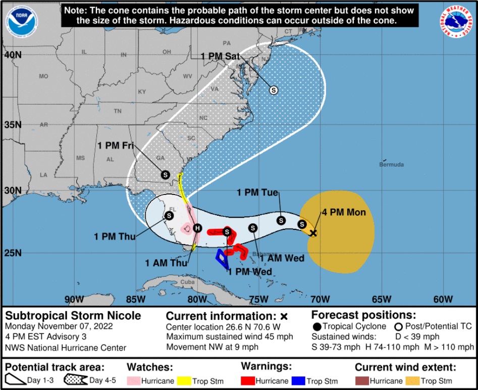
(NHC) At 1000 AM EST (1500 UTC), the center of Tropical Storm Nicole was located near latitude 27.8 North, longitude 72.7 West. Nicole is moving toward the west near 9 mph (15 km/h). A west to west-southwest motion should continue through Wednesday. A west-northwest motion is forecast to begin on Wednesday night, followed by a turn toward the northwest and north-northwest on Thursday and Thursday night.
On the forecast track, the center of Nicole will approach the northwestern Bahamas today and tonight, move near or over those islands on Wednesday, and approach the east coast of Florida within the hurricane warning area Wednesday night. Nicole’s center is then expected to move across central and northern Florida into southern Georgia Thursday and Thursday night.
Maximum sustained winds are near 50 mph (85 km/h) with higher gusts. Strengthening is expected during the next 36 to 48 hours, and Nicole is forecast to be near or at hurricane strength by Wednesday and Wednesday night while it is moving near the northwestern Bahamas and approaching the east coast of Florida. (more)
The majority of my advice below is for the Florida EAST COAST:
All coastal residents are urged to pay close attention to local officials for evacuation orders. Each locality is different, each coastal locality has a zone of potential flooding and storm surge. As a general rule, hunker down from wind – but evacuate from water.
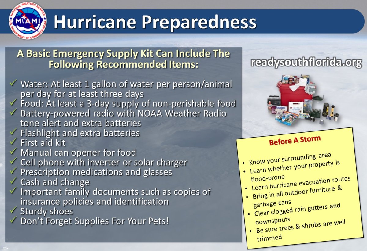
Today is a good day to organize your important papers, insurance forms, personal papers and place them in one ‘ready-to-go’ location.
Evaluate your personal hurricane and storm supplies; update and replace anything you might have used. Assess, modify and/or update any possible evacuation plans based on your location, and/or any changes to your family status. Fill car with gasoline. Review prescriptions, refill if needed.
Check your shutters and window coverings; test your generator; re-organize and familiarize yourself with all of your supplies and hardware. Check batteries in portable tools; locate tools you might need; walk your property to consider what you may need to do based on the storm’s path. All decisions are yours. You are in control.
Consider travel plans based on roads and traffic density. Being proactive now helps to keep any future stress level low. You are in control. If you have pets, additional plans may be needed.
Do your laundry. Sanitize and stage your water storage. Inventory your supplies. Organize your tools. Fill your freezer with water jugs to take up room and freeze. Test your generator. Stage your extension cords. Stage your battery powered devices. Test your weather radio. Take small steps to prepare. Secure your home. You are in full control.
Hardening your home is a matter of careful thought and physical work. Put 3/4-inch plywood or steel bolted hurricane shutters over all your windows and doors. This is not an option. Every window and door need to be protected, especially glass patio doors (even if tempered). Do not think you can stand there and protect glass doors. It’s beyond dangerous.
You can always tell those people who have been through direct hurricane impacts by how they parked their cars. If you have two vehicles, put one vehicle inside the garage with the front bumper against the door to help stop the flex (do this carefully). Put the other vehicle outside blocking the garage door facing down the driveway or facing parallel to the garage. The goal is to use the aero dynamics of the car to push the wind away from the garage door and provide protection.
Purchase a cheap car cover to protect the outside vehicle and/or use old blankets (cable ties, bungee cords) to stop the outside vehicle from getting sandblasted and destroyed. Place double folded corrugated cardboard in front of the radiator to protect it from storm debris.
[Additionally, if you live in a flood zone, or if you are concerned about storm surge, the day before impact take your #1 car to the nearest airport or hotel with a parking garage and park in the upper levels. Take an uber back home if you don’t have a friend or partner to help you. This way you know you will have one workable vehicle, just in case.]
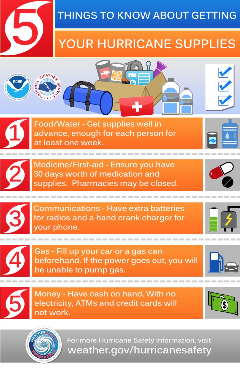
Beyond the ordinary supplies like drinking water, batteries, flashlights, battery or hand-crank radio, generators, gasoline, etc. Evaluate the scale of what you have against the likelihood of days or weeks without power or water (the timeframe depends on your location to the eyewall of the storm itself). A few pro tips below:
♦ Put three 30-gallon trash cans in the shower and fill them with water before the storm. This will give you 90 gallons of water for cooking and personal hygiene. You will also need water to manually flush your toilets. Bottled water is great for drinking, hydrating and toothbrushing, but you will need much more potable water if the municipal supply is compromised or broken.
♦ A standard 6,500-to-8,500-watt generator will run for approximately 8 hours on five gallons of gasoline. Do not run it all the time. Turn it on, chill the fridge, make coffee, use the microwave or charge stuff, then turn it off. Do this in 4-hour shifts and the fridge will be ok and your gasoline will last longer. Gasoline is a scarce and rare commodity in the aftermath of a hurricane. Gas stations don’t work without power. Check the oil in the generator every few days. Also, have a can of quick start or butane available in case the generator starts acting up.
♦ Extension cords. If you are purchasing them buy at least one 100 to 150′ extension cord with a triple ponytail. This way you can use one cord into a central location to charge up your electronic devices. Establish a central recharging station for phones, pads, laptops, and rechargeable stuff.
♦ Purchase a box of “contractor garbage bags” and just keep them in the garage. These are large, thick, industrial trash bags that fit 40-gallon drums. They can be used for trash, or even cut open for tarps in the aftermath of a storm. These thick mil contractor bags have multiple uses following a hurricane.
♦ Do all of your laundry before the hurricane hits. You will likely not have the ability again for a few days/weeks.
♦ Cook a week’s worth of meals in advance of the hurricane. Store in fridge so you can microwave for a meal. Eating a constant diet of sandwiches gets old after the first week. Dinty Moore canned beef stew and or Chef-boy-ardee raviolis can make a nice break…. anything, except another sandwich.
♦ Have bleach for use in disinfecting stuff before and after a hurricane. Also have antibiotics and antiseptics for use. Hygiene and not getting simple infections after a hurricane is critical and often forgotten. Again, this is where the extra potable water becomes important. Simple cuts and scrapes become big deals when clean potable water is not regularly available. Keep your scrapes and abrasions clean and use antiseptic creams immediately.
♦ Do not forget sunscreen and things to relieve muscle aches and pains. Hurricane recovery involves physical effort. You will be sore and/or exposed to the elements. Remember, it’s all about self-sufficiency because the normal services are not available. A well-equipped first aid kit is a must have.
♦ Buy a small camping stove. Nothing big or expensive, just something you can cook on outside in case of emergency. It will be a luxury when you are 2+ weeks without power and all the stores and restaurants are closed for miles.
♦ Those small flashlights that you can strap around your head that take a few AAA batteries? Yup, GOLD. Those types of handsfree flashlights are lifesavers inside and outside when you need to see your way around. Nighttime is especially dark without electricity in the entire town. Doing stuff like filling a generator with gasoline in the middle of the night is much easier with one of those head strap flashlights. Strongly advise getting a few, they’re inexpensive too.
♦ Cash. You will need it. Without power anything you may need to purchase will require cash, especially gasoline. Additionally, anyone you hire to help or support your immediate efforts will need to be paid. Cash is critical. How much, depends on your individual situation, but your cash burn rate will likely go into the thousands in the first few days. Also keep in mind, you may or may not be able to work and without internet access even getting funds into place, or paying bills electronically, could be challenging.
♦ Hardware. A box of self-tapping sheet metal screws (short and long) is important, along with a box or two of various wood screws or Tyvex screws. A battery drill or screw gun is another necessity. Check all of this stuff during hurricane prep.
Keep a positive outlook at all times. Do not fall into the trap of mental exhaustion, frustration and crisis. Write down your plans and then check them off so you can reward your brain with the sense of accomplishment. Trust me, this works. Keep a stable and optimistic disposition. Be flexible and charitable toward everyone.
Do not be alarmed – but take every preventative measure your individual situation needs. Work your hurricane plan and stay focused on what you do control. Proactive planning prevents stress. Work the plan, step by step and focus only on what is in front of you. Ignore the dark imaginings and turn off the national media. Pay attention to your local officials and local media.
Above all, pray. Be kind, retain a servant’s heart, be strong and deliberate while remaining focused as a good steward for your family, friends and community.
Posted originally on the conservative tree house on November 7, 2022
There are only two words that come to mind as I write this notice from the Ian impact zone, “mercy” and “uncle.” Prayers.
STS Nicole is anticipated to become a Cat-1 Hurricane as it approaches the southeast coast of Florida late Wednesday night. A Hurricane warning is in effect for the Northeast Bahamas, and a Hurricane Watch is in effect for the East Coast of Florida from the Volusia/Brevard County Line to Hallandale Beach. Residents along the Florida east coast should watch for updates [Hurricane Center Link].
If you are on the east coast of Florida, you should begin preparations today and tomorrow for the potential of high winds, power outages, coastal storm surge and inland flooding. Georgia and South Carolina should also keep an eye on this.
Additionally, on the other side of the state, while Nicole is not anticipated to be a strong hurricane and will hopefully lose strength quickly as it moves over land, any tropical storm winds and rain along the southwest Florida areas (SWFL) previously impacted by Ian could be very troublesome. Everything is tenuously held together in SWFL and there is massive debris and structural instability present as recovery efforts continue. This is not good.
(NHC) – At 400 PM EST (2100 UTC), the center of Subtropical Storm Nicole was located near latitude 26.6 North, longitude 70.6 West. The storm is moving toward the northwest near 9 mph (15 km/h). A slower northwestward motion is expected tonight. A turn toward the west or west-southwest is forecast to begin by Tuesday night and that motion should continue through early Thursday. On the forecast track, the center of Nicole will approach the northwestern Bahamas on Tuesday and Tuesday night, move near or over those islands on Wednesday, and approach the east coast of Florida Wednesday night. (more)
There is no such thing as an “easy hurricane,” only various degrees of deadly.
All coastal residents are urged to pay close attention to local officials for evacuation orders. Each locality is different, each coastal locality has a zone of potential flooding and storm surge. As a general rule, hunker down from wind – but evacuate from water.
Right now, you are in control. Do not be alarmed – but take every preventative measure your individual situation needs. Work your hurricane plan and stay focused on what you do control. Proactive planning prevents piss-poor performance. Work the plan, step by step and focus on what is in front of you. Ignore the dark imaginings and turn off the national media. Pay attention to your local officials and local media.
Do your laundry. Sanitize and stage your water storage. Inventory your supplies. Organize your tools. Fill your freezer with water jugs to take up room and freeze. Test your generator. Stage your extension cords. Stage your battery powered devices. Test your weather radio. Take small steps to prepare. Secure your home. You are in full control.
The #1 priority is to keep calm. Keep stable. If other people around you are panicked, do not let it impact your plan. Stay focused. Stay organized. Stay in control. I cannot emphasize enough how important it is for everyone around you and your family.
Check your hurricane supplies of shelf-stable food, water, medicine and don’t forget pets. Prepare for the worst and hope for the best. Everything is replaceable, except you and your family. We have a lot of Treepers in the path of this storm. If you need assistance, use the comments section of any ‘Update thread’ to reach out, or use the email address in the upper right of the site.
Right now, you are in control. Have a solid plan, work that plan – stay busy, and don’t get caught up in the hysteria. Try to avoid national media hype. Stay updated via your local news stations. Reach out to your neighbors; touch-base and check to see if they are okay or need anything. Community restoration begins before the storm arrives. Look out for each-other.
Regarding any evacuation plan, please pay attention to your local officials who will be coordinating with state Dept. of Transportation. As the path and impact zone of the storm becomes more predictable your local officials will alert to best route(s) for evacuation. For those in the cone of uncertainty; remember, planning and proactive measures taken now can significantly reduce stress in the days ahead.
DAY ONE (Today)
Determine Your Risk
Make a Written Plan
Develop an Evacuation Plan
Inventory hurricane/storm supplies.
Withdraw cash based on plan/need.
Get gas and storm supplies
DAY TWO (Tue)
Get Storm Update
Assemble and purchase any missing Hurricane Supplies
Contact Insurance Company – Updates
Secure Important Papers.
Update/upload your phone data.
Strengthen and Secure Your Home
Discuss Evacuation Decision with your Family.
Fill freezer with 3/4 full water jugs.
DAY THREE (Wed)
Get Storm Update
Re-Evaluate your Supplies based on storm update
Finish last minute preparation
Plan for a minimum of THREE DAYS without power
Assist Your Neighbors
If Needed – Evacuate Your Family
.
Communication is important. Update your friends and family contact list. Stay in touch with family and friends, let them know your plans. Select a single point of contact for communication from you that all others can then contact for updates if needed.
Today/tomorrow are good days to organize your important papers, insurance forms, personal papers and place them in one ‘ready-to-go’ location.
Evaluate your personal hurricane and storm supplies; update and replace anything you might have used. Assess, modify and/or update any possible evacuation plans based on your location, and/or any changes to your family status. Fill car with gasoline. Review prescriptions, refill if needed.
Check your shutters and window coverings; test your generator; re-organize and familiarize yourself with all of your supplies and hardware. Check batteries in portable tools; locate tools you might need; walk your property to consider what you may need to do based on the storm’s path. All decisions are yours. You are in control.
Consider travel plans based on roads and traffic density. Being proactive now helps to keep any future stress level low. You are in control. If you have pets, additional plans may be needed.
One possible proactive measure is to make a hotel reservation further inland that you would consider evacuating to. Follow updates of the storms’ progress; make reservations if determined; you can always cancel if not needed. It is better to have a secondary evacuation place established in advance. Being proactive reduces stress. Even if you wait until much later to cancel, it is better to pay a cancellation fee (usually one night charge) than to not have a plan on where to go. Trust me, it’s worth it. Protect your family.
If you are in the SWFL region where Hurricane Ian cleanup and recovery is still underway, just do the best you can to keep the debris in check as potential tropical storm force winds will be a major pain in the a**! Heavy sigh. ::spit::
Posted originally on the conservative tree house November 4, 2022 | Sundance
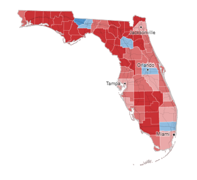
Miami-Dade County has long been the stronghold of Democrat voters in Florida. With more than 1.5 million registered voters in the county Miami-Dade has long been the backstop for Democrats in Florida. With deep red areas in the Southwest coast and Florida panhandle area, the axiom has long been said: ‘lose Miami-Dade and Democrats lose Florida’.
That said, incredibly Republicans in Miami-Dade are outvoting Democrats. [DATA HERE] This is happening despite the recent visit by Joe Biden to Miami to generate support for the blue ticket. With President Trump being the most supported political figure in the region; and with President Trump bringing the final finishing nails this weekend for a rally in Miami-Dade on behalf of the republican ticket, Democrats are apoplectic.
FLORIDA – […] “This is not what we expected,” said Christine Alexandria Olivio, the Democratic House candidate in Florida’s 26th Congressional District in South Florida. “This is worse than what we expected. We’re getting our butts kicked right now.” She was running against Republican Rep. Mario Díaz-Balart, the longest-serving member of Congress in Florida.
Registered Democrats still outnumbered Republicans in Miami-Dade, but the latest figures indicated Democrats – at least so far – were voting in far fewer numbers than their GOP counterparts.
The swing toward higher Republican turnout in the county – with just one week before the election – was widely interpreted as a sign of support among the area’s Hispanic voters for incumbent Republican Gov. Ron DeSantis – and a lack of enthusiasm for his Democratic challenger, Rep. Charlie Crist. The county is nearly 72% Hispanic.
[…] “The average citizen has woken up and has had enough of this nonsense,” Alina Garcia, the Republican candidate for a state House seat in Miami, wrote in an email. “That’s why you’re going to see Republicans outperform Democrats in such high numbers. That’s why you’ll see our proactive and highly effective governor get re-elected and, quite frankly, possibly win in Miami-Dade County.”
There were also signs of trouble for Democrats elsewhere: Republican turnout also had surpassed Democrats in the counties of Duval, home to Jacksonville, and Seminole, northeast of Orlando. GOP turnout was also unexpectedly high – but still behind Democratic voting – in Hillsborough County, home to Tampa.
In Pinellas County, west of Tampa, Republican turnout also was high compared to Democrats. The county is home to Crist’s seat in Congress.
The political climate might become even more dire for Democrats on Election Day: In previous elections, Democrats have traditionally voted early, with Republicans – who have eschewed voting by mail as unreliable – showing their highest turnouts on Election Day. It wasn’t clear why that pattern looks different so far this year, but the figures showed Republicans appear more comfortable casting ballots by mail.
There were signs of a Republican surge in South Florida in earlier elections. (more)
This shift within Miami-Dade is specifically attributable to Donald Trump and the America First MAGA agenda that resonates with working class people across all backgrounds. The economics of the MAGA platform cuts through all social distinctions and generates a massive block of voters who understand how the Trump domestic economic platform has a positive impact on the lives of working-class Americans.
The MAGA movement has flipped the political dynamic. The economics of the America First agenda unites everyone.
Making America Great Again benefits every working-class voter.
If there is going to be a red wave next week, the Tsunami will begin from the earthquake results in Florida politics.
Posted originally on the conservative tree house on November 1, 2022 | Sundance
Charlie Crist is a political weasel; a notorious lying liar who lies and who will say anything to keep his career in politics alive. Former Governor Charlie Crist is the worst form of politician created in the same mold as former South Carolina Governor Nikki Haley.
Today, despite mountains of evidence showing masks never provided any benefit, Charlie Crist told an audience that he would be open to mandating masks again for all Floridians. {Direct Rumble Link} At this point in history mask wearing is akin to virtue-signaling theater, although it does help to identify the moonbats among us. WATCH:
Posted originally on the conservative tree house on October 31, 2022 | sundance
In a previous update I noted the scale of debris cleanup ongoing as an outcome of Hurricane Ian. Several people made inquiries wanting to better understand the overall magnitude. So, I took some pictures today to share.
According to one of the debris contractor officials I incidentally bumped into, he shared how the debris cleanup was bid to the municipal regions using an actuarial formula from prior disaster recovery. It’s a pretty interesting, albeit heartbreaking, formula and overall process to understand.
After a geographic region is identified, an interim helicopter flight by specifically trained experts in the industry of debris removal is conducted. The general statistics applied to the contracts are for seven years’ worth of normal debris in the municipal region.
Meaning whatever tonnage is normally accumulated in municipal trash pickup over a year (garbage and recycling), that tonnage number is then multiplied by seven, and that’s the amount of debris anticipated during the initial hurricane debris removal. Seven years’ worth of ‘trash’.
More pictures below to help understand.
♦DEBRIS – The scale of physical debris is jaw dropping. FEMA reimburses local municipalities for the first 30 days of debris removal effort and costs. The 30-day limit is intended as a financial incentive to kick municipalities into fast action. This incentive is not a bad concept. Factually, it’s one of the better FEMA legislative standards because it forces local government to act quickly. However, the scale of what they are trying to do is just intense.
The various municipal governments in the severe impact zones appear to have a strategy to use the 30-day window to just collect as much as possible in interim geographic locations. Large empty lots (example below) are being utilized as fast dumps for massive piles of debris in this 30-day window. A claw truck can make a dozen fast runs (per day) locally to these interim dump sites, as opposed to driving long distances to landfills 30 to 50 miles away.
One of these 10-acre dump sites is less than a mile from me. I do not know how many of these exist; however, to see a full ten acres piled high with 10 to 20′ of debris gives me a sense of the scale of damage in this one small area within a region that must have hundreds of these interim sites. I have been to a dozen post-hurricane recovery areas and never seen debris like this.
Everything from destroyed construction material, to home furnishings, beds, appliances, parts of boats, roof parts, toys, patio furniture, pieces of cars, clothing, you name it, it’s all there. All now defined under the term “debris.” However, each piece of debris representing the former life of a family impacted by this storm. The trucks just keep coming, day and night 24/7. [Logistics tower for one 10-acre collection site pictured below]
In the bigger picture, when you think about what is represented, it’s a sullen site to bear witness to… Any person of reasonable Christian disposition would just cry. They have fenced off these interim dumping sites, and they have erected lights and temporary crane towers to seemingly assist the logistics of what goes where, but my God the scale of it is humbling. This is just one site utilized for an area of what seems to be approximately 5 square miles. Expand that scale to hundreds of similar 10-acre sites. Yeah, tears.
Eventually I assume these interim sites will be cleared one truckload at a time to the inner state landfills and recycle facilities. That phase will likely take years.
That’s a small snapshot.
Multiple those images times several thousand streets and similar areas.
Now you know what things look like.
Now you also know why Starfish Kid stays focused on the two feet in front of him…
…. If you look up for too long, the whispers of despair will try to get you.
Posted originally on the conservative tree house on October 29, 2022 | Sundance
The ‘context’ of Ian was shared previously {Go Deep}. Here we outline things to consider if you are prepping for a hurricane impact and/or deciding whether to stay in your home or evacuate. Standard hurricane preparations should always be followed. Protect your family, secure your property and belongings, and prepare for the aftermath.
What you do before the hurricane hits is going to determine where you are in the recovery phase.
Additionally, and this should be emphasized and discussed within your family, if you cannot be self-sufficient in the aftermath – for any reason, then you should evacuate.
Self-sufficiency in this context requires being able to cope for up to several weeks:
(1) potentially without power; (2) potentially without potable running water (3) potentially without internet service; (4) potentially without communication outside the region; and (5) with limited municipal and private sector assistance. If you decide you cannot deal with these outcomes, you should evacuate.
Additionally, as a family or individual, you should also honestly evaluate:
(1) your physical abilities; (2) your emotional and psychological ability to withstand extreme pressures; and (3) your comfort in losing daily routines, familiar schedules and often overlooked things you might take for granted. Post hurricane recovery is fraught with stress, frustration and unforeseeable challenges.
I saw a video presented by a structural engineer who was sharing his experience with Hurricane Ian. I am going to use his video for a few references because even with professional credentials, some of the common mistakes people make are highlighted in his experience. Keep in mind his video is taken about 30 miles inland from where the majority impact area (coastal region) is located.
The video below was shot from the soft side (western side) of the storm, and if we were to scale the difference between his experience and a person who was located in/around Fort Myers Beach, Sanibel, Pine Island or Cape Coral, he would be around a “5” on a ten-point impact scale.
Meaning the severity of conditions 30 miles southeast of him was twice as severe as his inland experience.
Key Points – At the 21: 35 moment (prompted), notice how his #2 vehicle is parked outside. Also, at the 22:00 minute moment, notice what he is describing and showing with his garage door and how his #1 vehicle (a pickup truck) is positioned inside the garage. WATCH:
.
♦ This is exactly what I was talking about in hurricane preparation when discussing the garage door. If that videographer was located 30 miles southeast, and/or his house was positioned facing West, instead of North, his garage door would have failed. If you lose the garage door, YOU COULD LOSE YOUR ROOF.
You can always tell those people who have been through direct hurricane impacts by how they parked their cars. I have never included this in the hurricane advice before so it’s worth a mention. If you lose your Florida garage door you will more than likely lose your roof. That’s just the reality of having a massive opening in your structure to 150 mph winds that will lift the trusses.
If you have two vehicles, put one vehicle inside the garage with the front bumper against the door to help stop the flex (do this carefully). Put the other vehicle outside blocking the garage door facing down the driveway or facing parallel to the garage. The goal is to use the aero dynamics of the car to push the wind away from the door and provide protection.
Purchase a cheap car cover to protect the outside vehicle and/or use old blankets (cable ties, bungee cords) to stop the outside vehicle from getting sandblasted and destroyed. Place double folded corrugated cardboard in front of the radiator to protect it from storm debris.
Additionally, if you live in a flood zone, or if you are concerned about storm surge, the day before impact take your #1 car to the nearest airport or hotel with a parking garage and park in the upper levels. Take an uber back home if you don’t have a friend or partner to help you. This way you know you will have one workable vehicle, just in case.
♦ Another lesson from Ian, if you drive an electric vehicle and sustain saltwater intrusion (of any level) your car is not safe. Saltwater makes the vehicle batteries extremely dangerous, and they could spark or catch fire. Multiple homes survived Hurricane Ian only to have the electric car catch fire in the garage and burn the house to the ground. Hurricane rain is saltwater rain. The fire department was begging people to put their ev’s outside and not to plug them in. Dozens of ev’s also erupted in flames while driving down the streets after the storm.
Back to the video above…
♦ Notice at 24:30 of the video this professional structural engineer is standing and physically supporting his glass patio doors, with his wife, trying to keep them from breaking in due to wind and pressure changes. DO NOT DO THIS ! That is beyond dangerous. Any small item of debris (even a small twig or branch) could hit that window and shatter it, turning flying glass into instant flying blades.
Put 3/4-inch plywood or steel bolted hurricane shutters over all your windows and doors. Period. This is not an option. My steel bolted hurricane shutters were hit with debris so hard – whatever it was physically dented the steel. Every window and door need to be covered and protected, especially glass patio doors (even if tempered). Do not think you can stand there and protect glass doors. It’s beyond dangerous.
♦ Hardening your home is a matter of careful thought and physical work. However, every opening into your structure must be protected, leaving yourself with one small exit opportunity just in case. Hopefully you have a bolted door with no glass windows you can use as an emergency exit. If not, select a small window and leave only enough room uncovered for you to get out in case of emergency or structural collapse.
Beyond the ordinary supplies like drinking water, batteries, flashlights, battery or hand-crank radio, generators, gasoline, etc. Evaluate the scale of what you have against the likelihood of weeks without power or water. A few pro tips below:
♦ Put three 30-gallon trash cans in the shower and fill them with water before the storm. This will give you 90 gallons of water for cooking and personal hygiene. You will also need water to manually flush your toilets. Bottled water is great for drinking, hydrating and toothbrushing, but you will need much more potable water if the municipal supply is compromised or broken.
♦ A standard 6,500-to-8,500-watt generator will run for approximately 8 hours on five gallons of gasoline. Do not run it all the time. Turn it on, chill the fridge, make coffee, use the microwave or charge stuff, then turn it off. Do this in 4-hour shifts and the fridge will be ok and your gasoline will last longer. Gasoline is a scarce and rare commodity in the aftermath of a hurricane. Gas stations don’t work without power. Check the oil in the generator every few days. Also, have a can of quick start or butane available in case the generator starts acting up.
♦ Extension cords. If you are purchasing them buy at least one 100 to 150′ extension cord with a triple ponytail. This way you can use one cord into a central location to charge up your electronic devices. Establish a central recharging station for phones, pads, laptops, and rechargeable stuff.
♦ Purchase a box of “contractor garbage bags” and just keep them in the garage. These are large, thick, industrial trash bags that fit 40-gallon drums. They can be used for trash, or even cut open for tarps in the aftermath of a storm. These thick mil contractor bags have multiple uses following a hurricane.
♦ Do all of your laundry before the hurricane hits. You will likely not have the ability again for a few weeks.
♦ Cook a week’s worth of meals in advance of the hurricane. Store in fridge so you can microwave for a meal. Eating a constant diet of sandwiches gets old after the first week. Dinty Moore canned beef stew and or Chef-boy-ardee raviolis can make a nice break…. anything, except another sandwich.
♦ Have bleach for use in disinfecting stuff before and after a hurricane. Also have antibiotics and antiseptics for use. Hygiene and not getting simple infections after a hurricane is critical and often forgotten. Again, this is where the extra potable water becomes important. Simple cuts and scrapes become big deals when clean potable water is not regularly available. Keep your scrapes and abrasions clean and use antiseptic creams immediately.
♦ Do not forget sunscreen and things to relieve muscle aches and pains. Hurricane recovery involves physical effort. You will be sore and/or exposed to the elements. Remember, it’s all about self-sufficiency because the normal services are not available. A well-equipped first aid kit is a must have.
♦ Buy a small camping stove. Nothing big or expensive, just something you can cook on outside in case of emergency. It will be a luxury when you are 2+ weeks without power and all the stores and restaurants are closed for miles.
♦ Those small flashlights that you can strap around your head that take a few AAA batteries? Yup, GOLD. Those types of handsfree flashlights are lifesavers inside and outside when you need to see your way around. Nighttime is especially dark without electricity in the entire town. Doing stuff like filling a generator with gasoline in the middle of the night is much easier with one of those head strap flashlights. Strongly advise getting a few, they’re inexpensive too.
♦ Cash. You will need it. Without power anything you may need to purchase will require cash, especially gasoline. Additionally, anyone you hire to help or support your immediate efforts will need to be paid. Cash is critical. How much, depends on your individual situation, but your cash burn rate will likely go into the thousands in the first few days. Also keep in mind, you may or may not be able to work and without internet access even getting funds into place could be challenging.
♦ Hardware. A box of self-tapping sheet metal screws (short and long) is important, along with a box or two of various wood screws or Tyvex screws. A battery drill or screw gun is another necessity. Check all of this stuff during hurricane prep.
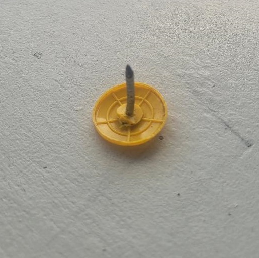
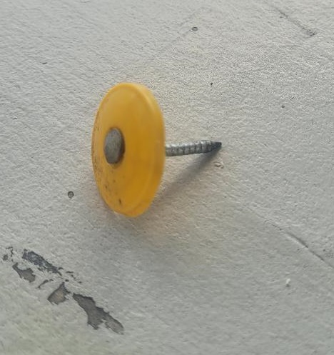
♦ ADD. I forget my #1 personal nemesis in the aftermath (pictured below):
Roofing nails. The pesky roofing nails. Thousands of em’, all over. Those buggers are everywhere, and they will go through a flip-flop, sneaker sole or car tire perfectly. Most of them are black (not yellow) like the ones above. Some of them have square of flat tops to help them stand up just perfect to find your tires.
I happen to believe roofing nails are actually tire magnets with some sort of automatic triggering system to jump in front of your car at the worst possible moments. On the positive side, I think my neighborhood is safe because my tires have picked up every one of em’. LOL and Grrrr…
More later…. but I hope this is useful. [Lie to me, even if it ain’t. lol.]
Posted originally on the conservative tree house on October 29, 2022 | Sundance
Many CTH readers know I have been involved in hurricane prep and recovery as a longtime member of a civilian emergency response team. I have physically been through four direct hurricane impacts and responded to recovery efforts in more than fifteen locations, often staying for days or weeks after the initial event.
Through the years I have advised readers on best practices for events before, during and after the storm. In this outline my goal is to take the experience from Hurricane Ian and overlay what worked and what doesn’t work from a perspective of the worst-case scenario.
Hurricane Ian was a worst-case scenario.
Let me be clear from the outset, I am not advising anyone to put greater weight on my opinion or ignore local emergency officials or professionals in/around the disaster areas. What I am going to provide below is my own experience after decades of this stuff, against the backdrop of Ian, and just provide information that you may wish to consider if you are ever faced with a similar situation.
Hurricane preparation can be overlaid against other types of disaster preparation, there are some commonalities. However, for the sake of those who live on/around the U.S. coastal areas where hurricanes have traditionally made impact, the specifics of preparation for this type of storm are more pertinent. I’m going to skip over the basic hurricane preparation and get into more obscure and granular details, actual stuff that matters, that many may not be familiar with.
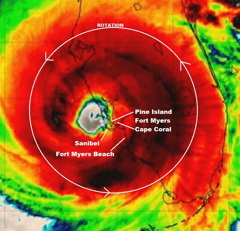
Let me start by sharing a graphic that you may overlay with the information you may have already seen from national media coverage. The graphic below shows Hurricane Ian in relation to Southwest Florida and points to locations that you may have seen on the news. The context of understanding Ian is going to be critical when contemplating preparation, so it must be emphasized.
This satellite image was likely taken around 4 to 7 pm on the evening of September 28, 2022, approximately three hours after Hurricane Ian officially made landfall at Bokeelia, a small community on the Northern end of Pine Island. All of my discussion below is from the ‘major impact zone’.
The satellite image above was taken during daylight after five or six hours of hurricane force winds (150+ mph) had already been impacting the SWFL coast.
For the areas of greatest impact, the event began roughly around 1:00pm and lasted until around 9:00pm. Ignore the red and dark area (rainfall) and instead focus on the green/blue ring around the eye, that is the “eye wall”, or what we call the “buzzsaw“.
From the perspective of the Fort Myers Beach, Cape Coral, Pine Island and Sanibel area, the first round of severe winds came from East to West around lunchtime on 9/28.
By 2pm the entire SWFL coastal region was without power. The easterly wind lasted about 2 hours, then as hurricane Ian meandered off the coast (retaining fuel) in a generally north-northeast direction, the winds shifted coming from the South. This is when the buzzsaw really started destroying buildings and infrastructure.
Ian was only moving in a forward direction around 5 to 8mph. That 150 mph buzzsaw (eyewall) is about 40 miles wide. Only half of the buzzsaw (the eastern side) was over land. The western side was providing hot water fuel the entire time. That buzzsaw was over the SWFL coastline for more than 8 hours.
Sanibel Lighthouse, Before and After
At approximately 5pm the most severe part of the storm surge started coming into the SWFL coast as the South and West winds began pushing massive amounts of water from the Gulf of Mexico onto the coast.
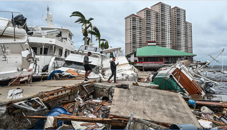
You have likely seen video from Fort Myers Beach as these moments were happening. The storm surge continued growing in scale for several hours. Combined with the wind, this storm surge is what erased most of the structures on Fort Myers Beach, Sanibel, Captiva, Upper Captiva Island, Saint James City, Pine Island, Matlacha and Bokeelia.
The 5 to 9pm timeframe is also when most of the flooding and storm surge damage took place in South Fort Myers and Cape Coral. Even after the buzzsaw cleared the area (9pm), the winds from the West at the bottom of the storm kept the water level high.
The water exit (back into the Gulf of Mexico) did not begin until the tidal shift after midnight. Due to the slow movement of the storm the total time of the storm surge impact was a jaw-dropping 8 to 10 hours. Many people drowned.
The old axiom remained mostly true, “hunker down from wind, but run from water.”
Now, I say “mostly true“, because to be brutally honest -due to the unique nature of Ian- if you are going to be inside that killer buzzsaw for 8 hours, hunkering down is really not a safe option. Fortunately, Ian was a rare system in terms of its slow-moving nature, even after hitting land. Most hurricane impact events are less than 3 hours in duration. Ian was dangerously unique.
To give scale to the size of the buzzsaw, again we are talking about the most dangerous part of any hurricane – the eyewall itself, this next image shows a comparison between the eyewall of Hurricane Charley in 2004 and the eyewall of Hurricane Ian in 2022.
That is the eye of Charley overlaid inside the eye of Ian in almost the same location. You can see how much bigger the buzzsaw was for Ian as opposed to Charley.
Both Hurricane Charley (’04) and Hurricane Ian (’22) came ashore in generally the same place. Charley made official landfall at Upper Captiva Island and Ian at Bokeelia. The distance between both landfall locations is only about 4 miles apart as the crow flies.
Both storms were Cat-4 landfall events. However, Charley was much smaller, had a smaller buzzsaw and moved quickly around 20 mph. Ian was big, had a much bigger buzzsaw and moved slowly around 5pmh.
The duration of Charley was around 2 to 3 hrs. The duration of Ian was around 8 to 9 hrs. Ian was bigger and just moved slower. Inside this distinction you discover why, despite their almost identical regional proximity, the damage from Ian was much more severe. Topography was changed.
I am focusing a lot of time on this similarity aspect because you cannot take a previous storm reference as a context for your ability to survive the next storm. They are all different, even when they hit the same place.
While more SWFL people evacuated for Hurricane Ian, and that is a profoundly good thing, the memory of getting through Hurricane Charley likely made many people think they could just prep, hunker down and get through it. The “I got this” reference of surviving through Charley may have led to people dying, because Ian wasn’t Charley…. not even close.
Having said that, I personally over prepare for these events. This time it was critical.
You have likely seen video from the hurricane area during the event. You have likely seen video from areas in/around the impact zone.
However, let me tell you something you have not seen…..
…. you have not seen any video of what was happening inside that eyewall. You have not seen any video of the buzzsaw at work.
Why? Because anyone who would attempt to step outside a structure into that buzzsaw would not survive. Any CCTV equipment, camera or video recording attached to a structure inside that coastal buzzsaw was almost certainly destroyed.
A physical human body does not step into 150 MPH winds and return.
This is a fury of nature, a battle where the odds are against you, that you may or may not be aware you are contemplating when you are choosing to stay or evacuate. It’s not the hurricane per se’, it’s that much smaller killer buzzsaw – the eyewall- that you are rolling the dice, never to see.
When it comes to the eyewall, the truest measure of the “cone of uncertainty“, the difference between scared out of your mind and almost certain death, is literally a matter of a few miles,…. and there ain’t no changing your mind once it starts.
Posted originally on the conservative tree house on October 25, 2022 | Sundance
Florida Governor Ron DeSantis and the lying liar who lies, Charlie Crist, held their one and only debate last night. Of all the gubernatorial debates so far, this one was probably the best. Thankfully, DeSantis won the debate on substance because Crist just sucks. However, DeSantis flubbed the most predictable question that was asked.
Every Floridian should vote for DeSantis, because Crist is just an unbearable alternative. That said, the insufferable Charlie Crist asked Governor DeSantis to commit to a four-year term in office and promise the Florida voters he would not abandon his state to run for the GOP nomination in 2024; effectively making DeSantis only a six-month reelected governor because national campaigning will start in June 2023.
It is true, the question should have come from the moderator, because it’s a transparently obvious and predictable question. However, regardless of who actually asked it, the non-response from Governor DeSantis was telling. WATCH (just first minute):
.
A few things about that non-response are remarkable.
First, even a middle school debate coach would have known that question was likely in the debate. The fact that DeSantis did not have a well-rehearsed and prepared canned answer to the question is a reflection of stunningly poor debate prep.
Second, the evasive and non-truthful answer he did give, totally avoiding the question, shows the incredible weakness within a candidate that is a specific outcome of a lack of honesty. That response is also reflective of why Donald Trump wins every debate. Trump wields truth as an effective weapon.
HONESTY – Ron DeSantis could have said, “Charlie, because of my successful leadership in the state of Florida, there are a lot of people who want me to run for the GOP nomination in 2024. There are also a lot of people offering money as an incentive for me to make that decision because the current state of our nation under Joe Biden is in such a mess. Whether I will or not is an open question that voters should consider; but I can assure everyone my work on behalf of Florida -a state I love- will never change.”
That type of an answer would be honest and respected. Florida voters deserve to know where Governor DeSantis stands on a 2024 presidential campaign. After all, it will consume most of the focus and time of the governor for 18 months before November 2024.
That type of an answer should also have been canned in a response awaiting the question. The absence of that type of an honest answer tells us something about the campaign authenticity aspect to Ron DeSantis.
The truth has no agenda, while the absence of truth always does.
This authenticity aspect is why Donald Trump won every one of the dozen debates in 2015 and 2016. He just speaks the truth regardless of comfort, expectation or disposition.
Q: “You have called women fat pigs etc.?” – A: “Only Rosie O’Donnell”…
Q: “You called Mexicans rapists etc.?” – A: “Well, someone’s doing the raping”…
Q: “You only support people who like you?” – A: “It’s true. I only like the people who like me”…
Q: “You have been talking to Kim Jong-un?” – A: “True. Shouldn’t we talk to everyone and try to avoid conflict? We also got along great”…
There’s no pretense in Trump’s responses. There is an authenticity in the humanness of the honesty. Trump wins debates because he answers the questions honestly as he sees them. He’s not uncomfortable being honest about his intent, reasons or even his own self-image.
Ron DeSantis on the other hand avoids his own discomfort in answering a question that should have been easily predicted. There is something very unnerving about it.
Every Floridian should vote for Ron DeSantis, granting him the benefit of the doubt that he will be around as governor for the next four years. However, if/when DeSantis wins reelection, he would destroy his own career by announcing a 2024 run six months later.
I have created this site to help people have fun in the kitchen. I write about enjoying life both in and out of my kitchen. Life is short! Make the most of it and enjoy!
This is a library of News Events not reported by the Main Stream Media documenting & connecting the dots on How the Obama Marxist Liberal agenda is destroying America