Florida Governor Ron DeSantis Gives Update on West Coast of Florida Evacuation Plans


Posted originally on the conservative tree house on September 26, 2022 | sundance 

With the forecasted path of Hurricane Ian anticipated to bring high water and winds to the west coast of Florida there is the potential for major storm surge in specific regions. Florida Governor Ron DeSantis held a press conference from Pinellas County to outline the latest information. WATCH: 

 ~ Florida Disaster Website as Outlined ~

TALLAHASSEE, Fla. — This morning, Governor Ron DeSantis issued updates on Hurricane Ian at the State Emergency Operations Center with Florida Division of Emergency Management Director Kevin Guthrie. Full remarks from this morning’s press conference are available here.

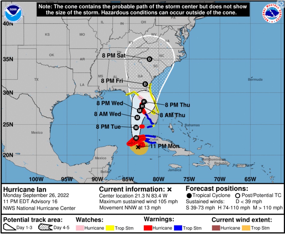
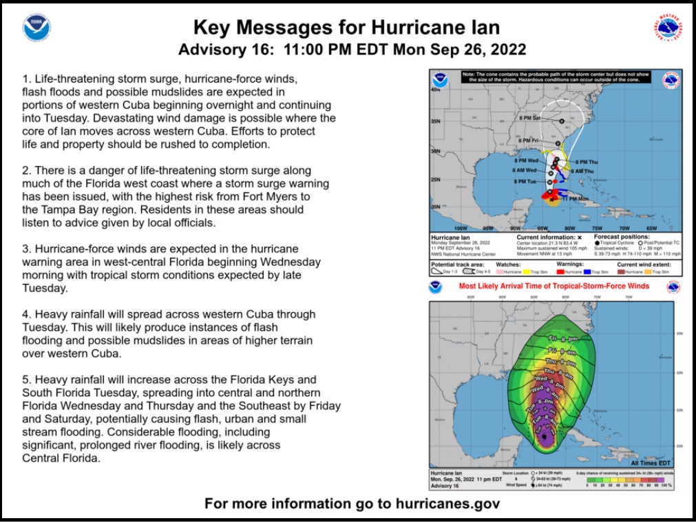
Hurricane Ian became a Category 1 hurricane this morning and is projected to continue strengthening into a major hurricane this week. Tropical-storm force winds may begin as soon as tonight in the Florida Keys and southern Florida. Regardless of Ian’s exact track and intensity, there is a significant risk of life-threatening storm surge, hurricane-force winds, and heavy rainfall along the west coast of Florida and the Florida Panhandle by the middle of this week.

Current Watches and Warnings in Effect:

  • Tropical Storm Warnings are in effect for the Lower Keys (from the 7 Mile Bridge southward to Key West, and the Dry Tortugas).
  • Tropical Storm Watches are in effect for portions of the Florida Gulf Coast stretching from Englewood to Chokoloskee (Charlotte, Collier, and Lee Counties).
  • A Hurricane Watch is in effect for Englewood to the Anclote River, including Tampa Bay.
  • Storm Surge Watches are in effect for the Florida Keys and mainland Monroe County, as well as far southern Miami-Dade, Collier, coastal Lee, the Tampa Bay area and coastal Charlotte counties.
  • Anclote River to Longboat Key including Tampa Bay… 5-10 ft
  • Longboat Key to Englewood… 5-8 ft.
  • Englewood to Bonita Beach, FL… 4-7 ft
  • Bonita Beach to East Cape Sable, FL… 3-5 ft
  • East Cape Sable to Card Sound Bridge, FL including Florida Bay…2-4 ft
  • Florida Keys including the Dry Tortugas… 2-4 ft

State preparation and response efforts include:

Florida Division of Emergency Management (FDEM)

  • FDEM is leading the State Emergency Response Team (SERT) for the Hurricane Ian response.
  • The Division has received 361 resource requests for Hurricane Ian, and has already fulfilled 293 of those requests. Additional requests are currently being processed and are either en route or being mobilized. This includes the coordination of resources such as: trucks of food and water, generators, and water pumps.
  • Five Urban Search and Rescue (USAR) Teams are activated, and will be prepared to deploy to impacted areas.
  • FDEM has begun setting up a Logistical Staging Areas in Polk County and is identifying potential additional staging areas and points of distribution to ensure food and water are readily available if counties request it.
  • FDEM has loaded 360 trailers with over 2 million meals and over one million gallons of water in preparation for distribution to impacted areas.
  • FDEM is in constant communication with all 67 county emergency management offices and state agencies to coordinate protective actions and needed resources ahead of potential storm impacts.
  • FDEM is coordinating with utilities to ensure crews are prepared to respond and restore power. Utility providers have more than 25,000 linemen staged and prepared for power restoration efforts.

Florida National Guard

  • Following Governor DeSantis’ authorization, a total of 5,000 Florida Guardsmen are being activated to State Active Duty and pre-positioned at armories across the state for Tropical Storm Ian response operations. Two thousand Guardsmen from Tennessee, Georgia and North Carolina are also being activated to assist.
  • The Florida National Guard is currently supporting missions including staffing and supporting the State Logistics Response Center (SLRC) in Orlando.
  • In addition, the Florida Guard has mobilized and is on standby with five Route Clearance Teams and Aviation assets.
  • The Florida National Guard is well-equipped, with assets including high-wheeled vehicles, helicopters, boats, generators and more.

Florida Department of Health (DOH)

  • DOH continues to coordinate across 67 county health departments on any necessary preparation resources, in coordination with county emergency managers.
  • The Department has coordinated with the Office of Insurance Regulation to distribute an alert regarding permitted early prescription refills during a State of Emergency. This alert was sent to health insurers, managed care organizations, health entities, and licensed health care providers. The alert can be found here.
  • The Department is supporting Special Needs Shelter operations in areas of anticipated landfall.
  • Nearly 300 ambulances, paratransit busses, and support vehicles are being deployed in areas of anticipated landfall.
  • The Department has coordinated with Federal partners to support the deployment of nearly 100 individuals through various health and medical teams. These teams stand ready in Orlando, Atlanta, and Warner Robbins Air Force Base in Georgia.

Agency for Health Care Administration (AHCA)

  • AHCA is requiring health providers to update the Health Facility Reporting System by 10 AM daily to ensure each facility is taking the appropriate precautions to ensure patient safety.
  • AHCA has completed 124 onsite visits in Nursing Homes and ALFs that were previously identified as out of compliance with generator requirements. As of today, 100% of operating long-term care facilities have a generator on-site. The Generator Status Map for long-term care facilities is available here.
  • AHCA has reminded all Medicaid Managed Care Plans of the requirement to allow 30-day emergency prescription refills of maintenance medication.

Agency for Persons with Disabilities (APD)

  • APD sent a statewide message to remind customers to register for the Special Needs Registry if needed.

Florida Department of Children and Families (DCF)

  • DCF submitted a request for a federal waiver to release SNAP benefits early in preparation for Hurricane Ian.
  • DCF has been working with contracted partners, including, Managing Entities, Community Based Care lead agencies, and child care providers to ensure Florida’s communities remain apprised of all storm updates and are making preparations for potential impacts.
  • DCF is also ensuring all Mental Health Treatment Facilities and methadone treatment programs are prepared for the storm.

Florida Department of Veterans Affairs (FDVA)

  • The Bay Pines VA Healthcare System will close the following locations for in person and procedure appointments:
  • C.W. Bill Young VA Medical Center: Monday, Sept. 26 through Thursday, Sept. 29. This closure extends to the Emergency Department.
  • North Pinellas and St. Petersburg VA Clinics: Wednesday, Sept. 28 and Thursday, Sept. 29.
  • Sarasota, Bradenton, and Port Charlotte VA Clinics: Wednesday, Sept. 28.

Florida Department of Transportation (FDOT)

  • To help Florida families safely and quickly evacuate in preparation of Hurricane Ian, tolls are now being suspended on many facilities in the projected areas of impact. Tolls will be suspended as of 12:00 PM today for the following:
  1. Polk Parkway in Polk County
  2. Suncoast Parkway in Pasco, Hernando, Hillsborough, and Citrus counties
  3. Veterans Expressway in Hillsborough County
  4. I-4 Connector in Hillsborough County
  5. Selmon Expressway in Hillsborough County
  6. Pinellas Bayway in Pinellas County
  7. Sunshine Skyway Bridge in Pinellas County
  8. Garcon Point Bridge in Santa Rosa County
  9. Spence Parkway in Okaloosa County
  10. Mid-Bay Bridge in Okaloosa County
  11. Alligator Alley in Collier and Broward Counties
  • FDOT contractors on all active construction projects are securing work sites, clearing traffic control devices that are not actively being used to direct traffic, and checking drainage systems.
  • Additional Road Rangers have been deployed to assist motorists along critical roadways.
  • The SunRail corridor is being secured to prepare for the storm. SunRail services will be discontinued effective Tuesday at 8:30am and will tentatively resume on Friday morning.
  • Florida’s 511 Traveler Information System is available for drivers to stay informed about roadway conditions during emergencies. The service includes traffic conditions, road and bridge closures, toll suspensions, and other specialized alerts. To use Florida’s 511, visit the website at FL511.com or download the app—on both Apple and Android devices.
  • On Saturday, September 24, FDOT waived standard weight restrictions for commercial vehicles transporting fuel, emergency equipment, services, supplies, and agriculture commodities and citrus. Commercial vehicles now will have an increased weight restriction to transport goods.
  • FDOT is monitoring traffic levels along critical corridors to ensure safe flow of traffic as the storm’s predicted path becomes clearer.
  • FDOT is staging resources to perform road and bridge inspections after the storm.
  • FDOT is procuring and staging resources to perform cut-and-toss operations to expedite roadway openings after the storm.
  • FDOT is activating district emergency and pre-event contracts for post-storm operations including debris removal, traffic signal and lighting repairs, and generators.
  • FDOT is coordinating with the Florida Highway Patrol, other law enforcement agencies, and Georgia DOT partners in support of potential evacuations, as well as with the Florida Department of Environmental Protection regarding debris management sites.
  • FDOT is working with utility providers to coordinate post-storm debris operations in support of electrical power restoration.
  • FDOT is coordinating with U.S. Coast Guard on movable bridge lockdowns.

Florida Department of Highway Safety

and Motor Vehicles (FLHSMV)

  • The Florida Highway Patrol is prepared to implement 12-hour Alpha, Bravo shifts in response to Hurricane Ian.
  • FLHSMV has issued Emergency Order 092422, which:
    • Waives specific requirements for commercial motor vehicles providing emergency relief; and
    • Waives the replacement fees for driver’s license and identification credentials, vehicle registrations and titles, vessel registrations and titles and temporary parking permits for impacted individuals.

Florida Wildlife Commission (FWC)

  • On September 23, at Governor DeSantis’ direction, the Florida Fish and Wildlife Conservation Commission (FWC) readied high-water vehicles and all other storm response resources so they may be rapidly deployed to assist Floridians in need in the event of any damage or flooding.
  • FWC officers in all 67 Florida counties have been placed on heightened alert status, in anticipation of heavy rains and flooding because of Hurricane Ian. High-water vehicles and shallow draft vessels in all Florida counties have been readied for immediate deployment to affected areas. Contingency plans based on forecasted landfall locations have been developed and are flexible based on the storm’s projected path.
  • Officers will respond with a variety of specialized equipment, including shallow draft boats, larger platform vessels, ATVs, airboats, and four-wheel drive vehicles. These assets do not include local FWC officers in potentially affected areas.
  • FWC Special Operations Group (SOG) teams will serve as reconnaissance units for the State EOC and report back on damage after the storm has made landfall.
  • FWC Aviation Section has been placed on standby and has readied all appropriate aircraft for potential deployment for EOC aerial assistance, reconnaissance, and post-storm damage assessments when needed.

Florida Department of Economic Opportunity (DEO)

  • DEO has activated the private sector hotline at 850-815-4925 from 8:00 a.m. to 6:00 p.m. Inquiries may also be emailed to ESF18@em.myflorida.com.
  • Partners including Walmart and Publix have indicated that they are constantly bringing additional supplies into the state to restock inventory.
  • DEO is updating www.FloridaDisaster.biz with real-time information for business owners to prepare their businesses, families, and employees for Hurricane Ian

Florida Department of Environmental Protection (DEP)

  • Following the issuance of the Governor’s Executive Order, DEP issued an Emergency Final Order waiving permitting requirements for the storage and processing of solid waste, including storm debris.
  • DEP has also issued an Emergency Final Order to expedite necessary repair, replacement and restoration of structures, equipment, surface water management systems, works and other systems damaged by the storm.
  • Inspectors completed pre-storm beach surveys in all shoreline counties.
  • Hazardous Area Response Teams (HARTs) are preparing for potential assessment and deployment to impacted areas.
  • All significant Hazardous Waste facilities within the affected counties have been contacted to ensure all pre-storm landfall preparations are being made.
  • Florida state park closures can be found at www.floridastateparks.org/StormUpdates.
  • Visitors with existing camping and cabin reservations at impacted parks will be notified of their reservation status.
  • WaterTracker is active, DEP’s online portal for wastewater and drinking water facilities to report their operational status.

Florida Department of Education (DOE)

The Florida Department of Education is consistently updating their website with county school closures, for a list visit fldoe.org/storminfo.

K12 School Closures

  • Hernando County Schools will be closed Tuesday, September 27 through Friday, September 30, 2022.
  • Hillsborough County Schools will be closed Monday, September 26 through Thursday, September 29, 2022.
  • Lake County Schools will have early dismissal on Tuesday, September 27 and will be closed Wednesday, September 28 and Thursday, September 29, 2022.
  • Pasco County Schools will be closed Tuesday, September 27 and Wednesday, September 28, 2022.
  • Pinellas County Schools will be closed Tuesday, September 27 and Wednesday, September 28, 2022.
  • Sarasota County Schools will be closed beginning Tuesday, September 27.

Florida College System Closures

  • Hillsborough Community College will be closed Tuesday, September 27 through Thursday, September 29, 2022.
  • St. Petersburg College will be closed Tuesday, September 27 and Wednesday, September 28, 2022.
  • State College of Florida will be closed Tuesday, September 27 through Friday, September 30, 2022.

State University Closures

  • New College of Florida classes will be canceled Monday, September 26 through Friday, September 30, 2022.
  • University of South Florida classes will be canceled Monday, September 26 through Thursday, September 29, 2022. Campuses will be closed starting Tuesday, September 27, 2022.

Florida Department of Management Services (DMS)

  • State buildings in Hillsborough County will be closed tomorrow, Tuesday, September 27, 2022. An updated list of state building closures is available here.
  • The Telecommunications Division is working with telecom partners to ensure that the state’s communications networks have redundancies and remain operations for first responders to respond to Floridians during the storm.

Posted in FEMAHurricane IanRon DeSantisUncategorized

Hurricane Ian Update 11pm, West Coast Florida Residents Complete Preparation Tuesday Without Delay, Coastal Residents Pay Attention to Local Officials For Evacuation Orders


Posted originally on the conservative tree house on September 27, 2022 | sundance 

[National Hurricane Center Data]  As of 11:00pm ET Monday, Hurricane Ian has maximum sustained winds of 105 mph [Category 2].  Ian is anticipated to strengthen rapidly in the next 24 hours as it enters the Gulf of Mexico as a major hurricane [Cat 3+].  All west coast Florida residents from Bonita Springs to Tampa should use Tuesday to finalize their hurricane preparations.

Tuesday is the last good weather day to finish your preparations and secure your property.  Do not be alarmed but do take this hurricane seriously. This is not a ‘wait and see’ type storm.  All reasonable precautions should be completed today, and all coastal residents are urged to pay close attention to local officials for any evacuation orders.  Each locality is different, each coastal locality has a zone of potential flooding and storm surge.  As a general rule, hunker down from wind – but evacuate from water.

Official projections put the storm just off the Florida west coast on Wednesday night, with the potential for a 24-hour duration cycle. That is an alarming amount of time for a major hurricane to be centered near or on the coast.  That is a minimum of two tidal cycles, which will make a big difference from prior hurricanes in terms of flooding and the potential for a historic storm surge into inland waterways.

Hurricanes can be frightening; downright scary. There’s nothing quite like going through a few to reset your outlook on just how Mother Nature can deliver a cleansing cycle to an entire geographic region.  If this storm rests on/near the coast for the projected duration (24 hrs), things could be much more sketchy than other hurricanes.  This possibility is not something to dismiss.  No one in Florida has a reference.

The geography on the south side of the storm faces the possibility of inbound wind and water for two tides, very uncommon.  Additionally, with outbound water limited by the pressure of inbound tides, the Peace River will flood, potentially at a historic level.  Let us hope the official forecasts are wrong, but we need to plan for this.  Projected rainfall is up to ten inches.

The deepest water will occur along the immediate coast near and to the right of the center, where the surge will be accompanied by large waves. Surge-related flooding depends on the relative timing of the surge and the tidal cycle, and can vary greatly over short distances. For information specific to your area, please see products issued by your local National Weather Service forecast office. [HERE’S LINK]  Pay attention to local officials.

Do not panic, but work your plan.

Dangerous coastal area storm surges are now predicted from Fort Myers north into Tampa Bay (south side of storm).  Please outline your communication plan with your family.  Select a specific person outside the area to be your immediate contact. That person then relays information to the rest of your family.  Please do this [Example Why].

Right now, you are in control.  Do not be alarmed – but take every preventative measure your individual situation needs.  Work your hurricane plan and stay focused on what you do control.  Work the plan, step by step and focus on what is in front of you.  Ignore the dark imaginings and turn off the national media.  Pay attention to your local officials and local media.

Finish your laundry. Sanitize and stage your water storage.  Inventory your supplies.  Organize your tools.  Fill your freezer with water jugs to take up room and freeze.  Test your generator. Stage your extension cords. Stage your battery powered devices. Test your weather radio. Take small steps to prepare.  Secure your home. You are in full control.  Today is the day to finish all preparation tasks.

The #1 priority is to keep calm. Keep stable.  If other people around you are panicked, do not let it impact your plan.  Stay focused. Stay organized. Stay in control.  I cannot emphasize enough how important it is for everyone around you and your family.  Everything is replaceable, except you and your family.  We have a lot of Treepers in the path of this storm. If you need assistance, use the comments section of any ‘Update thread’ to reach out, or use the email address in the upper right of the site.

DAY THREE (Tue/Wed)

  • Get Storm Update
  • Re-Evaluate your Supplies based on storm update
  • Finish last minute preparation
  • Plan for a minimum of THREE DAYS without power
  • Assist Your Neighbors
  • If Needed – Evacuate Your Family

.

Communication is important.  Update your friends and family contact list. Stay in touch with family and friends, let them know your plans. Select a single point of contact for communication from you that all others can then contact for updates if needed.

Telephone and power poles, yes, even the concrete ones, can, and likely will, snap like toothpicks. There’s a sound when you are inside a hurricane that you can never forget.

It ain’t a howling wind, it’s a roar. A damn scary raging roar that just won’t quit….

It will quit… eventually… but at the time you are hearing it, it doesn’t seem like it will ever end.

A constant and pure rage of scary wind that doesn’t ebb and flow like normal wind and storms… hurricane wind just starts and stays, sometimes for hours.

This type of wind is relentless and damn scary.  It takes you to that state where you begin to doubt things, it just won’t let up.

And then, depending on her irrelevant opinion toward your insignificant presence, she stops.

Then silence.

No birds. No frogs. No crickets. No sound.

Nature goes mute. It’s weird.

We have no idea how much ambient noise is around us, until it stops.

Oh, if she wants, she’ll keep dumping buckets on you as she wanders away. Buckets. Not pails, garbage can size buckets. After the scour, yup, nature too has a rinse cycle.

Prayers for all those in Ian’s path.

Pray together and be strong together.  It might sound goofy to some, but don’t be bashful about prayer – it works.

It will be ok.

Last point, housekeeping.  Most of the long-term Treepers know I will likely be unavailable as Civilian Emergency Response Teams (CERT) are activated.  The daily threads are auto scheduled to post, and the site admins will update on events if/when I am unavailable. My apologies to those who have written complaining that CTH is not providing the comprehensive coverage of political news.

Unfortunately, home base for all current research will consist of three duffel bags, a laptop, generator and a well-suited 4×4; loaded with power tools, emergency kits and assorted roughneck supplies. I will make every effort to return to political research and analysis – as soon as current logistics, community safety and overall concerns are abated. As part of FL CERT, we reposition outside of the storm surge area.  As a consequence, during the logistical move I will be out of the loop for most of the morning and early afternoon Tuesday.

To ensure continuance of communication, CTH has auto-scheduled posts set up throughout the week which will run automatically without any need for human data entry.  [ie. the website is secure and will function as normal – and site admins are disbursed throughout unaffected time zones] Other than my absence (hopefully sporadic), you should not see any disruption.

What can YOU DO?

Please pray for the people of Florida.  This is an extremely stressful time for many people, including a significant amount of elderly.  Unfortunately, due to modern disconnection a considerable number of people do not have frequent contact with family, COVID made this issue worse.

If you know people in Florida, please just reach out to them via social media, email, text, etc and let them know they are in your thoughts and prayers.  You don’t have to call them, you don’t need to look for a response, but a short note -just touching base- via social media (Facebook etc.), with kind words, can mean the world to people who might be feeling isolated.

Trust me, I’ve seen those faces all day.  It matters.

The Rhine Drought


Armstrong Economics Blog/World Trade Re-Posted Aug 11, 2022 by Martin Armstrong

The drought across Europe has caused substantial problems. In Germany, the Rhine has all but evaporated. Freights have been forced to reduce their loads across the river, but some are foregoing the route altogether. German authorities have not closed the river but are permitting shippers to cross at their own risk — and it is a risk many are not willing to take. Shipping vessels have been sailing half to a quarter full, according to Reuters, adding to the supply chain bottleneck. Numerous companies are shifting to railway transportation but that will take time.

Around 80% of all goods transported to Germany via waterways come through the Rhine and this passageway is crucial for all of Europe. The last major drought occurred in 2018, prompting German authorities to close the passage for 132 days, which nearly triggered a financial crisis. The water was at a low of 27 cm in October 2018, and water levels are quickly rescinding.

Authorities will try to deter another shipping halt, but there won’t be much they can do if the water levels continue to drop. Some estimate that the Rhine will be closed to ships as soon as Friday. The implications will be far worse than in 2018, as there was not a global supply chain shortage exacerbating inflation.

The Drought Cycle & Climate Change


Armstrong Economics Blog/Climate Re-Posted Jul 28, 2022 by Martin Armstrong

QUESTION: Hello Martin and Team,

My question is related to a gentleman I watched on Greg Hunters Watchdog News that Martin goes on with from time to time. Greg interviewed —- —–. The discussion was around chemtrails and the gov’t messing with the rain patterns, also lake Mead and the Las Vegas drain plug which I do know is real. The main question is there a real likely hood of the S.W. United States to experience very serious drought in short order? I live in Phoenix and this interview was scary and I would be curious to know (along with millions of others) if Dane’s information is credible and if folks living in the S.W. US should really consider trying to move to another part of the country. I wondered if Socrates would be able to give us any insight into what was discussed in the interview.

Thank you so much for your efforts, I have been following Martin since 2008 and I have yet to see Socrates be wrong. We need your efforts more than ever with the complete disaster of the world we are living in.

Regards. DGB

ANSWER: I have no data on the chemtrail issue. My opinion would neither add nor detract from the subject. I prefer not to comment on things I have no experience in or information I cannot confirm. What I can say, rooted entirely in our database on weather, is that like stock markets or economies, there are cycles to droughts and will tend to last for 37 months. Curiously, this is also fractal being 8.6 x 4.3. Even during the 1930s drought episode that produced the Dust Bowl, the average longest stretch was also 37 months, peaking in March 1935.

There was a cycle inversion that took place during the 1950s, which caused a 19-year extension bringing the average drought to the longest stretch of 56 months, peaking in February 1957. While that drought was longer, it was not as intense as that of the 1930s Dust Bowl. The typical short-term events are reactions, and they are typically maxed out at three months.

That said, I can only look at the data. I do not see any alternation to the cycles insofar as altering their length. If the proposition of the chemtrail argument is valid, then I would assume from the data that, at the very best, it could possibly impact the “volatility” as we experience in a market that changes the intensity.

However, as of June 19, 2022, 51.87% of the lower 48 states are in a drought. We have not yet exceeded the high of 1159 AD. So much for fossil fuels creating global warming.

Climate Engineering: 40 Million in US West Without Water in 2023


Armstrong Economics Blog/Corruption Re-Posted Jul 22, 2022 by Martin Armstrong

Our models have been indicating a decline in both the food and water supply, which go hand-in-hand. Other analysts are coming out to warn that the inevitable cycle is underway. Climate engineering researcher Dane Wigington believes the cycle has been propelled forward by manmade forces. “The mainstream media and official sources are doing their best to sweep it under the rug. We are talking about 40 million people that will be impacted by the drying out of the Colorado River basin and tributaries.”

Interviewer Greg Hunter plainly asked Wigington if this was a deliberate attempt to diminish the population. “Yes,” he replied without hesitation. “There is no speculation, no hypothesis or conjecture in any of this. Climate engineering is the primary cause for the protracted drought, and not just in the U.S. but in many other parts of the world. It also causes a deluge scenario, and all of it is crushing crops. We can speculate to the motives and agendas behind those who run these operations, but the fact that climate engineering is the primary causal factor for the western drought is inarguable.”

Wigington sees extreme water rationing coming as soon as 2023. Once Lake Mead reaches “dead-pool” status, crops will die out, water will be unavailable for irrigation, and there will be no electrical power generation. Drought is causing water to evaporate at levels beyond what is reported in the mainstream media.

“This is a runaway train of total cataclysm, and those in power are preventing anyone from even discussing this issue down to the point that there is an illegal federal gag order on the nation’s weathermen at the National Weather Service and NOAA,” Wigington stated. The government would only place a gag order on reporters if there were something to hide. Climate engineering may be one of the new tools to fight future wars and control the population.

I’m adding this note: Some of this is real the water levels are dropping. Some of the rest is also possible because Bill Gates was testing this idea a while back.

An Important German Documentary on Ukraine


Armstrong Economics Blog/Ukraine Re-Posted May 7, 2022 by Martin Armstrong

This is a MUST-watch Documentary from a German journalist who has been on the ground. It is important to see the other side of events for anyone who only listens to one side, is denied the very idea of free thought.

A number of people asked to see an ECM on Zelensky himself. This lines up perfectly with the final wave for Ukraine as well between 2021 into 2025 where it is highly likely we will see war escalated post-2024. Zelensky got his staring role to pretend to be a comedian who became president in line with the ECM turning point 2016.75 which marked the peak in confidence in government globally. 2016 saw both Brexit and Trump win which were direct blows to the establishment.

The Coming Dust Bowl – 2025-2027?


Armstrong Economics Blog/Agriculture Re-Posted Mar 22, 2022 by Martin Armstrong

QUESTION: Marty; You have been the first to warn of food shortages and to stockpile for the years ahead. With Russia and Ukraine accounting for 30% of global wheat, you have warned that we are looking a shortages into 2032. Does this mean the war will last for 10 years?

LC

ANSWER: No, the forecasts for shortages into 2024 are actually divided into two primary causes. There was a major crisis in crop failures in 1846-1847, which also provided the economic reasons for the 1848 Communist Revolutions throughout Europe when agriculture was 70% of the economy back then. This was followed by the next great drought which became known as the “Dust Bowl” during the years of 1935-1936. Note, this had nothing to do with CO2 and the Industrial Revolution. While the Dust Bowl was a 10 year struggle for farmers, it certainly varied from city to city. Generally 1935 to 1936 was the worse of it and by 1937 the trend began to reverse.

Our model warns that we may see another severe drought probably between 2025 to 2027 in both the US and Canada. The drought conditions are already beginning and this is in line with our model which warns it will expand into the 2025-2027 period.

Therefore, to answer your question more directly, it appears that we have a shortage first instigated by the outrageous stupidity of COVID management, and this is the accelerated by the War Cycles, and it will conclude with the weather cycle which will only add to the shortages post-2024.

The Darndest Thing Happened on the Way Home From Work


Posted originally on the conservative tree house on March 22, 2022

Some guy driving a Chevy Silverado near Elgin, Texas, has 2021 and 2022 encapsulated.

.

Treehouse wife: “How was work?”

Treehouse hubby:  “Eh, ok.  Weird drive home though. How’s kids?”

Wife: “The usual, but Jack needs help with math tonight”…

Hubby: “Ok, I’ll be in the garage for a bit”.

You might remember this prior ad for Chevy Silverado.

.

Tenuous Winter Wheat Crops Could Become Problematic


Posted originally on the conservative tree house on March 20, 2022 | Sundance

Wheat is an essential grain harvest in the overall food chain.  Winter wheat is planted in October and harvested the following June and July, however, the U.S. crop this year is in a tenuous position because of severe drought in the plains.  Kansas represents about a quarter of the U.S. harvest and is currently suffering through an extended dry season.

Last week, “Kansas Governor Laura Kelly declared a drought emergency, warnings and watches for every county in Kansas on Thursday due to dry conditions causing high fire danger.” (link)

We need to keep an eye on this, and it would be wise to make proactive preparations now for the possibility of a severe shortage.  This potential is what has driven the price of wheat futures, and when combined with the issues in Europe’s largest wheat producer, Russia, there’s a very real possibility of a global shortage of wheat.

The early March warnings are beginning to become more important.  “The world has grown hugely dependent on Ukraine and Russia for their wheat, a crop used in everything from bread to couscous and noodles. The nations account for a quarter of global trade. They are also cheap suppliers, which makes their exports favorites for importers in the Middle East and North Africa, including in Egypt, the world’s biggest wheat buyer.” (link)

Back to the U.S.A:

March 14 (Reuters) – A worsening drought in the southern U.S. Plains is threatening the region’s winter wheat crop just as the Ukraine crisis dents global supplies.

Some farmers in southwestern Kansas, the top U.S. wheat producing state, have not received much measurable rain or snow since October. Winter wheat is planted in autumn, lays dormant in winter and begins sending up green shoots in spring. Proper soil moisture is critical at this stage for the crop to thrive.

More than half of Kansas was classified as under severe drought or worse as of March 8, the driest conditions since 2018, according to the National Drought Mitigation Center. Severe drought is also covering three-quarters of Oklahoma and more than two-thirds of Texas, both of which also are large wheat producers.

Water woes follow a freak December windstorm that swept away some topsoil in parts of the U.S. wheat belt, damaging some cropland.

U.S. hard red winter wheat represents nearly half of the country’s overall wheat production and is milled mainly for bread flour. A reduced crop could further stoke food inflation that the United Nations Food and Agriculture Organization (FAO) said was the highest-ever in February. The FAO’s Food Price Index averaged 140.7 points last month, a 20.7% increase from a year earlier and surpassing the 2011 record.

U.S. wheat futures soared to the highest levels in 14 years early last week as the Russia-Ukraine conflict pushed two of the world’s largest wheat exporters out of the market, leaving importing countries scrambling for replacement sources.

Meanwhile, the winter wheat crop in China, the world’s largest producer of the grain, is expected to be among the worst ever after heavy rainfall delayed planting. (read more)

We need to watch this one closely, and it would not be a bad idea to purchase some of your own bread making supplies a little earlier for storage.

Wheat, corn and soybeans are the foundation of the U.S. food supply. They are primarily used as ingredients in processed foods, oils, and are fed to the cattle, hogs, and poultry that supply meat and eggs for the American diet.  When those grain harvests go up in price, the downstream increase in price is far reaching.

Ok – Those who Voted for Biden & Want Global Cooling, Please Stay Out of Florida!


Armstrong Economics Blog/Climate Re-Posted Jan 26, 2022 by Martin Armstrong